 |
|
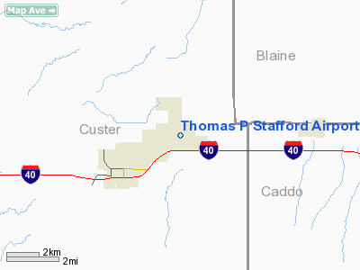
Thomas P Stafford Airport |
Location & QuickFacts
| FAA Information Effective: | 2008-09-25 |
| Airport Identifier: | OJA |
| Airport Status: | Operational |
| Longitude/Latitude: | 098-40-06.6000W/35-32-41.4000N
-98.668500/35.544833 (Estimated) |
| Elevation: | 1605 ft / 489.20 m (Surveyed) |
| Land: | 129 acres |
| From nearest city: | 2 nautical miles NE of Weatherford, OK |
| Location: | Custer County, OK |
| Magnetic Variation: | 06E (2005) |
Owner & Manager
| Ownership: | Publicly owned |
| Owner: | City Of Weatherford |
| Address: | 522 W. Rainey, P. O. Box 569
Weatherford, OK 73096 |
| Phone number: | 580-772-7451 |
| Manager: | John Creswell |
| Address: | 3000 Logan Road
Weatherford, OK 73096 |
| Phone number: | 580-774-1971 |
Airport Operations and Facilities
| Airport Use: | Open to public |
| Wind indicator: | Yes |
| Segmented Circle: | No |
| Control Tower: | No |
| Lighting Schedule: | DUSK-DAWN |
| Beacon Color: | Clear-Green (lighted land airport) |
| Landing fee charge: | No |
| Sectional chart: | Dallas-ft Worth |
| Region: | ASW - Southwest |
| Boundary ARTCC: | ZFW - Fort Worth |
| Tie-in FSS: | MLC - Mc Alester |
| FSS on Airport: | No |
| FSS Toll Free: | 1-800-WX-BRIEF |
| NOTAMs Facility: | MLC (NOTAM-d service avaliable) |
| Federal Agreements: | NGY |
Airport Communications
| CTAF: | 122.800 |
| Unicom: | 122.800 |
Airport Services
| Fuel available: | 100LLA |
| Airframe Repair: | MAJOR |
| Power Plant Repair: | MAJOR |
| Bottled Oxygen: | HIGH/LOW |
| Bulk Oxygen: | NONE |
Runway Information
Runway 17/35
| Dimension: | 4400 x 75 ft / 1341.1 x 22.9 m |
| Surface: | CONC, Good Condition |
| Pavement Class: | 4 /R/B/X/T |
| Weight Limit: | Single wheel: 30000 lbs.
Dual wheel: 48000 lbs. |
| Edge Lights: | Medium |
| |
Runway 17 |
Runway 35 |
| Longitude: | 098-40-06.6696W | 098-40-06.5595W |
| Latitude: | 35-33-03.1638N | 35-32-19.6511N |
| Elevation: | 1601.00 ft | 1599.00 ft |
| Alignment: | 127 | 127 |
| Traffic Pattern: | Left | Left |
| Markings: | Non-precision instrument, Good Condition | Non-precision instrument, Good Condition |
| Crossing Height: | 40.00 ft | 38.00 ft |
| VASI: | 2-light PAPI on left side | 2-light PAPI on left side |
| Visual Glide Angle: | 3.00° | 3.00° |
| Obstruction: | 34 ft trees, 980.0 ft from runway, 22:1 slope to clear | 41 ft pline, 1100.0 ft from runway, 21:1 slope to clear |
|
Radio Navigation Aids
| ID |
Type |
Name |
Ch |
Freq |
Var |
Dist |
| FSI | FAN MARKER | Trail | | | 09E | 47.7 nm |
| OJA | NDB | Weatherford | | 272.00 | 07E | 0.9 nm |
| CLK | NDB | Clinton | | 320.00 | 07E | 13.0 nm |
| JWG | NDB | Watonga | | 359.00 | 07E | 22.5 nm |
| BZ | NDB | Fossi | | 393.00 | 08E | 26.7 nm |
| RQO | NDB | El Reno | | 335.00 | 07E | 32.5 nm |
| EZY | NDB | Elk City | | 241.00 | 08E | 36.4 nm |
| OLR | NDB | Chickasha | | 290.00 | 07E | 43.2 nm |
| FAU | NDB | Fairview | | 246.00 | 07E | 45.5 nm |
| OFZ | NDB | Trail | | 388.00 | 09E | 47.7 nm |
| PWA | VOR/DME | Wiley Post | 081X | 113.40 | 08E | 50.0 nm |
| BFV | VORTAC | Burns Flat | 037X | 110.00 | 08E | 32.2 nm |
| IFI | VORTAC | Kingfisher | 094X | 114.70 | 09E | 36.0 nm |
| HBR | VORTAC | Hobart | 055X | 111.80 | 10E | 45.1 nm |
| SYO | VORTAC | Sayre | 099X | 115.20 | 10E | 48.8 nm |
Remarks
- GCO AVBL ON FREQ 135.075 THRU FLT SVCS.
Images and information placed above are from
http://www.airport-data.com/airport/OJA/
We thank them for the data!
| General Info
|
| Country |
United States
|
| State |
OKLAHOMA
|
| FAA ID |
OJA
|
| Time |
UTC-6(-5DT)
|
| Latitude |
35.544831
35° 32' 41.39" N
|
| Longitude |
-98.668492
098° 40' 06.57" W
|
| Elevation |
1605 feet
489 meters
|
| Type |
Civil
|
| Magnetic Variation |
005° E (01/06)
|
| Beacon |
Yes
|
| Operating Agency |
U.S.CIVIL AIRPORT WHEREIN PERMIT COVERS USE BY TRANSIT MILITARY AIRCRAFT
|
| Near City |
Weatherford
|
| Operating Hours |
SEE REMARKS FOR OPERATING HOURS OR COMMUNICATIONS FOR POSSIBLE HOURS
|
| Daylight Saving Time |
Second Sunday in March at 0200 to first Sunday in November at 0200 local time (Exception Arizona and that portion of Indiana in the Eastern Time Zone)
|
We don't guarantee the information is fresh and accurate. The data may
be wrong or outdated.
For more up-to-date information please refer to other sources.
|
|


