 |
|
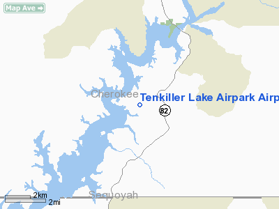
Tenkiller Lake Airpark Airport |
Location & QuickFacts
| FAA Information Effective: | 2008-09-25 |
| Airport Identifier: | 44M |
| Airport Status: | Operational |
| Longitude/Latitude: | 094-56-09.3800W/35-42-18.2300N
-94.935939/35.705064 (Estimated) |
| Elevation: | 877 ft / 267.31 m (Estimated) |
| Land: | 135 acres |
| From nearest city: | 1 nautical miles SW of Cookson, OK |
| Location: | Cherokee County, OK |
| Magnetic Variation: | 05E (1985) |
Owner & Manager
| Ownership: | Publicly owned |
| Owner: | Cherokee Co Arpt Trust Auth |
| Address: | 32248 S. Skyline Dr, P. O. Box 66
Cookson, OK 74427 |
| Phone number: | 918-457-3257 |
| Manager: | Forrest Wood |
| Address: | P. O. Box 100
Cookson, OK 74427 |
| Phone number: | 918-457-5907 |
Airport Operations and Facilities
| Airport Use: | Open to public |
| Wind indicator: | Yes |
| Segmented Circle: | Yes |
| Control Tower: | No |
| Lighting Schedule: | DUSK-DAWN
ACTVT LIRL RY 05/23 - CTAF. |
| Beacon Color: | Clear-Green (lighted land airport) |
| Landing fee charge: | No |
| Sectional chart: | Memphis |
| Region: | ASW - Southwest |
| Boundary ARTCC: | ZME - Memphis |
| Tie-in FSS: | MLC - Mc Alester |
| FSS on Airport: | No |
| FSS Toll Free: | 1-800-WX-BRIEF |
| NOTAMs Facility: | MLC (NOTAM-d service avaliable) |
Airport Communications
| CTAF: | 122.800 |
| Unicom: | 122.800 |
Airport Services
| Fuel available: | 100LL
FOR FUEL CALL 918-457-4033/5907. |
Runway Information
Runway 05/23
| Dimension: | 2600 x 75 ft / 792.5 x 22.9 m |
| Surface: | TURF, Good Condition |
| Edge Lights: | Low |
| |
Runway 05 |
Runway 23 |
| Traffic Pattern: | Left | Left |
| Crossing Height: | 31.00 ft | 33.00 ft |
| VASI: | 2-box on left side
VASI OTS INDEFLY. | 2-box on left side
VASI OTS INDEFLY. |
| Visual Glide Angle: | 3.00° | 3.50° |
| Obstruction: | , 50:1 slope to clear | 30 ft trees, 350.0 ft from runway, 150 ft right of centerline, 11:1 slope to clear |
|
Radio Navigation Aids
| ID |
Type |
Name |
Ch |
Freq |
Var |
Dist |
| TQH | NDB | Tahlequah | | 215.00 | 05E | 13.7 nm |
| MKO | NDB | Muskogee | | 306.00 | 06E | 18.4 nm |
| IQS | NDB | Sallisaw | | 520.00 | 05E | 19.7 nm |
| SLG | NDB | Siloam Springs | | 284.00 | 04E | 36.3 nm |
| MEE | VOR | Davis | | 108.60 | 06E | 21.2 nm |
| DAK | VOR/DME | Drake | 025X | 108.80 | 07E | 41.3 nm |
| OKM | VOR/DME | Okmulgee | 096X | 114.90 | 08E | 45.4 nm |
| FSM | VORTAC | Fort Smith | 041X | 110.40 | 07E | 37.7 nm |
Images and information placed above are from
http://www.airport-data.com/airport/44M/
We thank them for the data!
| General Info
|
| Country |
United States
|
| State |
OKLAHOMA
|
| FAA ID |
44M
|
| Latitude |
35-42-18.230N
|
| Longitude |
094-56-09.380W
|
| Elevation |
877 feet
|
| Near City |
COOKSON
|
We don't guarantee the information is fresh and accurate. The data may
be wrong or outdated.
For more up-to-date information please refer to other sources.
|
|


