 |
|
| Sundance Airpark |
| IATA: HSD – ICAO: KHSD – FAA LID: HSD |
| Summary |
| Airport type |
Public |
| Owner |
Sundance Airpark FBO, Inc. |
| Serves |
Oklahoma City, Oklahoma |
| Elevation AMSL |
1,193 ft / 364 m |
| Coordinates |
35°36′07″N 097°42′22″W / 35.60194°N 97.70611°W / 35.60194; -97.70611 |
| Website |
SundanceAirpark.com |
| Runways |
| Direction |
Length |
Surface |
| ft |
m |
| 17/35 |
5,001 |
1,524 |
Concrete |
| Statistics (2007) |
| Aircraft operations |
75,000 |
| Based aircraft |
142 |
| Source: Federal Aviation Administration |
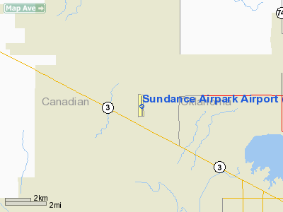
Sundance Airpark (IATA: HSD, ICAO: KHSD, FAA LID: HSD) is a public use airport located in Canadian County, Oklahoma, United States. The airport is 11 nautical miles (20 km) northwest of the central business district of Oklahoma City. It is privately owned by Sundance Airpark FBO, Inc.
Facilities and aircraft
Sundance Airpark covers an area of 240 acres (97 ha) at an elevation of 1,193 feet (364 m) above mean sea level. It has one runway designated 17/35 with a concrete surface measuring 5,001 by 100 feet (1,524 x 30 m).
For the 12-month period ending August 22, 2007, the airport had 75,000 general aviation aircraft operations, an average of 205 per day. At that time there were 142 aircraft based at this airport: 85% single-engine, 14% multi-engine and 1% jet.
The above content comes from Wikipedia and is published under free licenses – click here to read more.
Location & QuickFacts
| FAA Information Effective: | 2008-09-25 |
| Airport Identifier: | HSD |
| Airport Status: | Operational |
| Longitude/Latitude: | 097-42-22.1590W/35-36-06.5890N
-97.706155/35.601830 (Estimated) |
| Elevation: | 1193 ft / 363.63 m (Surveyed) |
| Land: | 240 acres |
| From nearest city: | 11 nautical miles NW of Oklahoma City, OK |
| Location: | Canadian County, OK |
| Magnetic Variation: | 07E (1985) |
Owner & Manager
| Ownership: | Privately owned |
| Owner: | Sundance Airpark Fbo, Inc.
GARY VARNELL, OWNER. |
| Address: | 12210 N Sara Rd
Yukon, OK 73099 |
| Phone number: | 405-388-9033 |
| Manager: | Doug Harnett |
| Address: | 12210 N Sara Rd
Yukon, OK 73099 |
| Phone number: | 405-373-3886 |
Airport Operations and Facilities
| Airport Use: | Open to public |
| Wind indicator: | Yes |
| Segmented Circle: | Yes |
| Control Tower: | No |
| Lighting Schedule: | DUSK-DAWN
ACTVT MIRL RY 17/35 AND VASI RYS 17 & 35 - CTAF. |
| Beacon Color: | Clear-Green (lighted land airport) |
| Sectional chart: | Dallas-ft Worth |
| Region: | ASW - Southwest |
| Boundary ARTCC: | ZFW - Fort Worth |
| Tie-in FSS: | MLC - Mc Alester |
| FSS on Airport: | No |
| FSS Toll Free: | 1-800-WX-BRIEF |
| NOTAMs Facility: | MLC (NOTAM-d service avaliable) |
Airport Communications
| CTAF: | 122.700 |
| Unicom: | 122.700 |
Airport Services
| Fuel available: | 100LLA
FUEL AVBL 24 HR SELF-SERVE WITH CREDIT CARD. |
Runway Information
Runway 17/35
| Dimension: | 5000 x 100 ft / 1524.0 x 30.5 m |
| Surface: | CONC, Good Condition |
| Edge Lights: | Medium |
| |
Runway 17 |
Runway 35 |
| Longitude: | 097-42-23.2250W | 097-42-21.0740W |
| Latitude: | 35-36-31.2980N | 35-35-41.8820N |
| Elevation: | 1153.00 ft | 1193.00 ft |
| Alignment: | 127 | 127 |
| ILS Type: | LOCALIZER
| |
| Traffic Pattern: | Right | Left |
| Markings: | Non-precision instrument, Good Condition | Non-precision instrument, Good Condition |
| Crossing Height: | 24.00 ft | 21.00 ft |
| VASI: | 2-box on left side | 2-box on left side |
| Visual Glide Angle: | 2.25° | 2.50° |
|
Radio Navigation Aids
| ID |
Type |
Name |
Ch |
Freq |
Var |
Dist |
| OK | NDB | Tuloo | | 406.00 | 07E | 9.3 nm |
| RQO | NDB | El Reno | | 335.00 | 07E | 16.6 nm |
| LCY | NDB | Logan County | | 326.00 | 07E | 20.4 nm |
| OUN | NDB | Norman | | 260.00 | 07E | 24.2 nm |
| OLR | NDB | Chickasha | | 290.00 | 07E | 32.6 nm |
| JWG | NDB | Watonga | | 359.00 | 07E | 38.4 nm |
| CQB | NDB | Tilghman | | 396.00 | 06E | 43.9 nm |
| OJA | NDB | Weatherford | | 272.00 | 07E | 47.4 nm |
| GGU | NDB | Prague | | 314.00 | 06E | 48.6 nm |
| CUH | NDB | Cushing | | 242.00 | 05E | 48.6 nm |
| TIK | TACAN | Tinker | 105X | | 07E | 18.8 nm |
| PWA | VOR/DME | Wiley Post | 081X | 113.40 | 08E | 5.0 nm |
| ODG | VOR/DME | Woodring | 027X | 109.00 | 08E | 46.6 nm |
| SWO | VOR/DME | Stillwater | 021X | 108.40 | 07E | 48.2 nm |
| IRW | VORTAC | Will Rogers | 088X | 114.10 | 07E | 15.4 nm |
| IFI | VORTAC | Kingfisher | 094X | 114.70 | 09E | 19.0 nm |
| END | VORTAC | Vance | 101X | 115.40 | 09E | 45.9 nm |
| OKC | VOT | Oklahoma Will Rgs W | | 108.80 | | 13.5 nm |
Remarks
- ULTRALIGHTS ON AND IN VICINITY OF AIRPORT.
- CONDL - PRVDD ALL TFC PAT OPNS SHOULD BE WEST OF THE ARPT'S N/S RWY; IE. ALL TURNS TO THE LEFT WHEN LNDG OR TAKING OFF TO THE NORTH & ALL TURNS TO THE RIGHT WHEN LNDG OR TAKING OFF TO THE SOUTH; ALL EASTBOUND DEPS SHOULD ESTAB RDO CTC WITH THE WILEY POST ATCT PRIOR TO DEP.
Images and information placed above are from
http://www.airport-data.com/airport/HSD/
We thank them for the data!
| General Info
|
| Country |
United States
|
| State |
OKLAHOMA
|
| FAA ID |
HSD
|
| Latitude |
35-36-06.589N
|
| Longitude |
097-42-22.159W
|
| Elevation |
1193 feet
|
| Near City |
OKLAHOMA CITY
|
We don't guarantee the information is fresh and accurate. The data may
be wrong or outdated.
For more up-to-date information please refer to other sources.
|
|


