 |
|
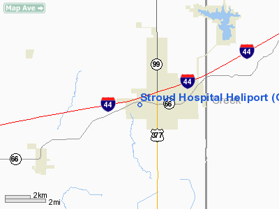
Location & QuickFacts
| FAA Information Effective: | 2008-09-25 |
| Airport Identifier: | OK86 |
| Airport Status: | Operational |
| Longitude/Latitude: | 096-40-41.0640W/35-44-55.2450N
-96.678073/35.748679 (Estimated) |
| Elevation: | 900 ft / 274.32 m (Estimated) |
| Land: | 0 acres |
| From nearest city: | 1 nautical miles W of Stroud, OK |
| Location: | Lincoln County, OK |
| Magnetic Variation: | 07E (1985) |
Owner & Manager
| Ownership: | Publicly owned |
| Owner: | Stroud Regional Medical Center |
| Address: | Highway 66 West
Stroud, OK 74079 |
| Phone number: | 918-968-3571 |
| Manager: | Beverly Hash
FOR QUESTIONS CONTACT: JOHN ALEXANDER JALEXANDER@STROUDHOSPITAL.COM 918-968-3571 |
| Address: | Highway 66 West
Stroud, OK 74079 |
| Phone number: | 918-968-3571 |
Airport Operations and Facilities
| Airport Use: | Private
MEDICAL. |
| Wind indicator: | Yes |
| Segmented Circle: | No |
| Control Tower: | No |
| Lighting Schedule: | PHONE REQ
FOR PERIMETER LIGHTS CALL (918) 968-3571. |
| Sectional chart: | Dallas-ft Worth |
| Region: | ASW - Southwest |
| Boundary ARTCC: | ZKC - Kansas City |
| Tie-in FSS: | MLC - Mc Alester |
| FSS Toll Free: | 1-800-WX-BRIEF |
Runway Information
Helipad H1
| Dimension: | 80 x 80 ft / 24.4 x 24.4 m |
| Surface: | TURF, |
| |
Runway H1 |
Runway |
| Traffic Pattern: | Left | Left |
|
Radio Navigation Aids
| ID |
Type |
Name |
Ch |
Freq |
Var |
Dist |
| CQB | NDB | Tilghman | | 396.00 | 06E | 7.0 nm |
| CUH | NDB | Cushing | | 242.00 | 05E | 9.7 nm |
| TZO | NDB | Bristow | | 251.00 | 05E | 12.4 nm |
| GGU | NDB | Prague | | 314.00 | 06E | 14.1 nm |
| SRE | NDB | Seminole | | 278.00 | 06E | 28.7 nm |
| OWP | NDB | William Pogue | | 362.00 | 06E | 36.1 nm |
| LCY | NDB | Logan County | | 326.00 | 07E | 36.4 nm |
| HET | NDB | Henryetta | | 267.00 | 04E | 38.5 nm |
| HDL | NDB | Holdenville | | 411.00 | 06E | 41.9 nm |
| OK | NDB | Tuloo | | 406.00 | 07E | 48.3 nm |
| OUN | NDB | Norman | | 260.00 | 07E | 49.1 nm |
| TIK | TACAN | Tinker | 105X | | 07E | 39.1 nm |
| SWO | VOR/DME | Stillwater | 021X | 108.40 | 07E | 34.7 nm |
| GNP | VOR/DME | Glenpool | 043X | 110.60 | 06E | 36.1 nm |
| OKM | VOR/DME | Okmulgee | 096X | 114.90 | 08E | 39.8 nm |
| PWA | VOR/DME | Wiley Post | 081X | 113.40 | 08E | 49.1 nm |
| OKC | VOT | Oklahoma Will Rgs W | | 108.80 | | 49.9 nm |
Images and information placed above are from
http://www.airport-data.com/airport/OK86/
We thank them for the data!
| General Info
|
| Country |
United States
|
| State |
OKLAHOMA
|
| FAA ID |
OK86
|
| Latitude |
35-44-55.245N
|
| Longitude |
096-40-41.064W
|
| Elevation |
900 feet
|
| Near City |
STROUD
|
We don't guarantee the information is fresh and accurate. The data may
be wrong or outdated.
For more up-to-date information please refer to other sources.
|
|


