 |
|
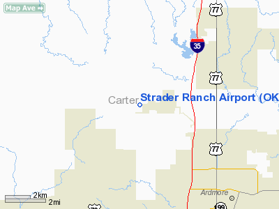
Location & QuickFacts
| FAA Information Effective: | 2008-09-25 |
| Airport Identifier: | OK62 |
| Airport Status: | Operational |
| Longitude/Latitude: | 097-12-33.0500W/34-14-55.3300N
-97.209181/34.248703 (Estimated) |
| Elevation: | 850 ft / 259.08 m (Estimated) |
| Land: | 198 acres |
| From nearest city: | 7 nautical miles SE of Ardmore, OK |
| Location: | Carter County, OK |
| Magnetic Variation: | 06E (1995) |
Owner & Manager
| Ownership: | Privately owned |
| Owner: | Wayne Strader |
| Address: | Rt 3 Box 21e
Ardmore, OK 73401 |
| Phone number: | 405-223-3096 |
| Manager: | Wayne Strader |
| Address: | Rt 3 Box 21e
Ardmore, OK 73401 |
| Phone number: | 405-223-3096 |
Airport Operations and Facilities
| Airport Use: | Private |
| Wind indicator: | Yes |
| Segmented Circle: | No |
| Control Tower: | No |
| Sectional chart: | Dallas-ft Worth |
| Region: | ASW - Southwest |
| Boundary ARTCC: | ZFW - Fort Worth |
| Tie-in FSS: | MLC - Mc Alester |
| FSS on Airport: | No |
| FSS Toll Free: | 1-800-WX-BRIEF |
Runway Information
Runway 14/32
| Dimension: | 2600 x 60 ft / 792.5 x 18.3 m |
| Surface: | TURF, |
| |
Runway 14 |
Runway 32 |
| Traffic Pattern: | Left | Left |
| Obstruction: | | 40 ft pline, 2500.0 ft from runway |
|
Radio Navigation Aids
| ID |
Type |
Name |
Ch |
Freq |
Var |
Dist |
| AUV | NDB | Arbuckle | | 284.00 | 07E | 7.2 nm |
| PVJ | NDB | Pauls Valley | | 384.00 | 06E | 28.1 nm |
| GLE | NDB | Gainesville | | 330.00 | 06E | 31.9 nm |
| DNI | NDB | Denison | | 341.00 | 06E | 37.1 nm |
| DUA | NDB | Durant | | 359.00 | 05E | 44.3 nm |
| GMZ | NDB | Grindstone Mountain | | 356.00 | 07E | 47.8 nm |
| DUC | VOR/DME | Duncan | 047X | 111.00 | 09E | 36.1 nm |
| ADH | VOR/DME | Ada | 125X | 117.80 | 06E | 42.7 nm |
| URH | VOR/DME | Texoma | 090X | 114.30 | 05E | 44.6 nm |
| ADM | VORTAC | Ardmore | 114X | 116.70 | 06E | 3.0 nm |
Remarks
- PRVDD RY THLDS BE DSPLCD TO PROVIDE A MINIMUM 20:1 CLEARANCE OVER ALL OBSTRUCTIONS IN APCH AREAS.
Images and information placed above are from
http://www.airport-data.com/airport/OK62/
We thank them for the data!
| General Info
|
| Country |
United States
|
| State |
OKLAHOMA
|
| FAA ID |
OK62
|
| Latitude |
34-14-55.330N
|
| Longitude |
097-12-33.050W
|
| Elevation |
850 feet
|
| Near City |
ARDMORE
|
We don't guarantee the information is fresh and accurate. The data may
be wrong or outdated.
For more up-to-date information please refer to other sources.
|
|


