 |
|
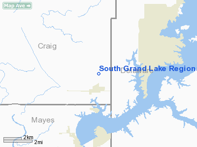
South Grand Lake Rgnl Airport |
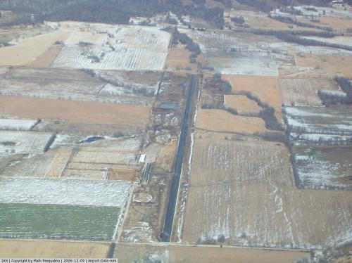 |
(Click on the photo to enlarge) |
Location & QuickFacts
| FAA Information Effective: | 2008-09-25 |
| Airport Identifier: | 1K8 |
| Airport Status: | Operational |
| Longitude/Latitude: | 095-01-15.8640W/36-32-30.2940N
-95.021073/36.541748 (Estimated) |
| Elevation: | 775 ft / 236.22 m (Estimated) |
| Land: | 57 acres |
| From nearest city: | 1 nautical miles NE of Ketchum, OK |
| Location: | Craig County, OK |
| Magnetic Variation: | 06E (1985) |
Owner & Manager
| Ownership: | Publicly owned |
| Owner: | Town Of Ketchum |
| Address: | P. O. Box 339
Langley, OK 74350 |
| Phone number: | 918-782-2244 |
| Manager: | Brent Howard
AUTHORITY CHAIRPERSON. |
| Address: | P. O. Box 339, Rt 3 Box 1557
Langley, OK 74350 |
| Phone number: | 918-782-1855 |
Airport Operations and Facilities
| Airport Use: | Open to public |
| Wind indicator: | Yes |
| Segmented Circle: | No |
| Control Tower: | No |
| Sectional chart: | Kansas City |
| Region: | ASW - Southwest |
| Boundary ARTCC: | ZKC - Kansas City |
| Tie-in FSS: | MLC - Mc Alester |
| FSS Toll Free: | 1-800-WX-BRIEF |
| NOTAMs Facility: | MLC (NOTAM-d service avaliable) |
| Federal Agreements: | N |
Airport Communications
Airport Services
Runway Information
Runway 18/36
| Dimension: | 4744 x 60 ft / 1446.0 x 18.3 m |
| Surface: | ASPH, |
| Weight Limit: | Single wheel: 30000 lbs.
Dual wheel: 60000 lbs. |
| |
Runway 18 |
Runway 36 |
| Traffic Pattern: | Left | Right |
| Markings: | Non-precision instrument, Good Condition | Non-precision instrument, Good Condition |
| Displaced threshold: | 447.00 ft | 437.00 ft |
| Obstruction: | 58 ft trees, 480.0 ft from runway, 4:1 slope to clear
APCH SLOPE 15:1 FM DSPLCD THLD. | 50 ft trees, 618.0 ft from runway, 8:1 slope to clear
APCH SLOPE 21:1 FM DSPLCD THLD. |
|
Radio Navigation Aids
| ID |
Type |
Name |
Ch |
Freq |
Var |
Dist |
| SLG | NDB | Siloam Springs | | 284.00 | 04E | 33.4 nm |
| TQH | NDB | Tahlequah | | 215.00 | 05E | 37.0 nm |
| CFV | NDB | Coffeyville | | 212.00 | 05E | 42.4 nm |
| DW | NDB | Owaso | | 375.00 | 06E | 43.6 nm |
| EOS | VOR/DME | Neosho | 120X | 117.30 | 07E | 33.5 nm |
| DAK | VOR/DME | Drake | 025X | 108.80 | 07E | 49.9 nm |
| OSW | VORTAC | Oswego | 123X | 117.60 | 08E | 38.0 nm |
| TUL | VORTAC | Tulsa | 091X | 114.40 | 08E | 42.5 nm |
| RZC | VORTAC | Razorback | 111X | 116.40 | 04E | 47.0 nm |
| TUL | VOT | Tulsa Intl | | 109.00 | | 42.5 nm |
Remarks
- PRVDD BOTH RYS THRS LCTD SO AS TO ASSURE A MINIMUM OF 20:1 CLEARANCE OVER ALL OBSTNS IN THE FINAL APPCH AREAS.
Images and information placed above are from
http://www.airport-data.com/airport/1K8/
We thank them for the data!
| General Info
|
| Country |
United States
|
| State |
OKLAHOMA
|
| FAA ID |
1K8
|
| Latitude |
36-32-30.294N
|
| Longitude |
095-01-15.864W
|
| Elevation |
775 feet
|
| Near City |
KETCHUM
|
We don't guarantee the information is fresh and accurate. The data may
be wrong or outdated.
For more up-to-date information please refer to other sources.
|
|


