 |
|
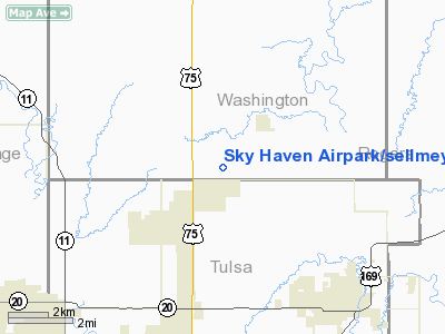
Sky Haven Airpark/sellmeyer Field Airport |
Location & QuickFacts
| FAA Information Effective: | 2008-09-25 |
| Airport Identifier: | OK01 |
| Airport Status: | Operational |
| Longitude/Latitude: | 095-54-11.9600W/36-25-44.3300N
-95.903322/36.428981 (Estimated) |
| Elevation: | 675 ft / 205.74 m (Estimated) |
| Land: | 0 acres |
| From nearest city: | 2 nautical miles SW of Vera, OK |
| Location: | Washington County, OK |
| Magnetic Variation: | 05E (2000) |
Owner & Manager
| Ownership: | Privately owned |
| Owner: | Eugene Sellmeyer |
| Address: | Rt 1 Box 418
Collinsville, OK 74021 |
| Phone number: | 405-371-2877 |
| Manager: | Eugene Sellmeyer |
| Address: | Rt 1 Box 418
Collinsville, OK 74021 |
| Phone number: | 405-371-2877 |
Airport Operations and Facilities
| Airport Use: | Private |
| Segmented Circle: | No |
| Control Tower: | No |
| Sectional chart: | Kansas City |
| Region: | ASW - Southwest |
| Boundary ARTCC: | ZKC - Kansas City |
| Tie-in FSS: | MLC - Mc Alester |
| FSS Toll Free: | 1-800-WX-BRIEF |
Airport Communications
Runway Information
Runway 17/35
| Dimension: | 4400 x 75 ft / 1341.1 x 22.9 m |
| Surface: | TURF, |
| |
Runway 17 |
Runway 35 |
| Traffic Pattern: | Left | Left |
|
Radio Navigation Aids
| ID |
Type |
Name |
Ch |
Freq |
Var |
Dist |
| DW | NDB | Owaso | | 375.00 | 06E | 7.4 nm |
| OWP | NDB | William Pogue | | 362.00 | 06E | 19.6 nm |
| CFV | NDB | Coffeyville | | 212.00 | 05E | 43.0 nm |
| TZO | NDB | Bristow | | 251.00 | 05E | 47.0 nm |
| BVO | VOR/DME | Bartlesville | 126X | 117.90 | 08E | 25.0 nm |
| GNP | VOR/DME | Glenpool | 043X | 110.60 | 06E | 30.7 nm |
| OKM | VOR/DME | Okmulgee | 096X | 114.90 | 08E | 44.3 nm |
| TUL | VORTAC | Tulsa | 091X | 114.40 | 08E | 15.1 nm |
| TUL | VOT | Tulsa Intl | | 109.00 | | 15.1 nm |
Remarks
- PRVDD OWNERS OF BLUESEN ARPT & SKY HAVEN AIRPARK COMPLY WITH CONDS IN LOA; & THERE IS A CLEAR 20:1 APCH CLEARANCE OVER ANY OBSTRUCTIONS IN APCH PATH.
Images and information placed above are from
http://www.airport-data.com/airport/OK01/
We thank them for the data!
| General Info
|
| Country |
United States
|
| State |
OKLAHOMA
|
| FAA ID |
OK01
|
| Latitude |
36-25-44.330N
|
| Longitude |
095-54-11.960W
|
| Elevation |
675 feet
|
| Near City |
VERA
|
We don't guarantee the information is fresh and accurate. The data may
be wrong or outdated.
For more up-to-date information please refer to other sources.
|
|


