 |
|
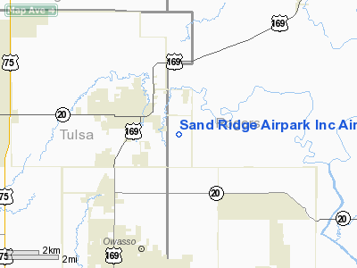
Sand Ridge Airpark Inc Airport |
Location & QuickFacts
| FAA Information Effective: | 2008-09-25 |
| Airport Identifier: | OK94 |
| Airport Status: | Operational |
| Longitude/Latitude: | 095-48-11.9490W/36-21-17.3400N
-95.803319/36.354817 (Estimated) |
| Elevation: | 675 ft / 205.74 m (Estimated) |
| Land: | 0 acres |
| From nearest city: | 2 nautical miles SE of Collinsville, OK |
| Location: | Rogers County, OK |
| Magnetic Variation: | 06E (1985) |
Owner & Manager
| Ownership: | Privately owned |
| Owner: | Sand Ridge Airpark Inc |
| Address: | Rr 2, Box 853
Collinsville, OK 74021 |
| Phone number: | 918-371-9589 |
| Manager: | Carolyn N. Gifford |
| Address: | 13865 N 152 E Ave
Collinsville, OK 74021 |
| Phone number: | 918-371-9589 |
Airport Operations and Facilities
| Airport Use: | Private |
| Wind indicator: | Yes |
| Segmented Circle: | No |
| Control Tower: | No |
| Lighting Schedule: | PHONE REQ
FOR LIRL RY 17/35 CALL 918-371-3528. |
| Landing fee charge: | No |
| Sectional chart: | Kansas City |
| Region: | ASW - Southwest |
| Boundary ARTCC: | ZKC - Kansas City |
| Tie-in FSS: | MLC - Mc Alester |
| FSS on Airport: | No |
| FSS Toll Free: | 1-800-WX-BRIEF |
Airport Services
| Airframe Repair: | NONE |
| Power Plant Repair: | NONE |
Runway Information
Runway 17/35
| Dimension: | 2400 x 130 ft / 731.5 x 39.6 m |
| Surface: | TURF, |
| Edge Lights: | Low |
| |
Runway 17 |
Runway 35 |
| Traffic Pattern: | Left | Left |
| Displaced threshold: | 300.00 ft | 0.00 ft |
|
Radio Navigation Aids
| ID |
Type |
Name |
Ch |
Freq |
Var |
Dist |
| DW | NDB | Owaso | | 375.00 | 06E | 4.5 nm |
| OWP | NDB | William Pogue | | 362.00 | 06E | 20.2 nm |
| CFV | NDB | Coffeyville | | 212.00 | 05E | 45.8 nm |
| TZO | NDB | Bristow | | 251.00 | 05E | 46.3 nm |
| TQH | NDB | Tahlequah | | 215.00 | 05E | 46.5 nm |
| MEE | VOR | Davis | | 108.60 | 06E | 46.7 nm |
| GNP | VOR/DME | Glenpool | 043X | 110.60 | 06E | 27.3 nm |
| BVO | VOR/DME | Bartlesville | 126X | 117.90 | 08E | 30.6 nm |
| OKM | VOR/DME | Okmulgee | 096X | 114.90 | 08E | 39.9 nm |
| TUL | VORTAC | Tulsa | 091X | 114.40 | 08E | 9.6 nm |
| TUL | VOT | Tulsa Intl | | 109.00 | | 9.6 nm |
Remarks
- CONFLICTS WITH APPROACHES TO TULSA INT'L.
Images and information placed above are from
http://www.airport-data.com/airport/OK94/
We thank them for the data!
| General Info
|
| Country |
United States
|
| State |
OKLAHOMA
|
| FAA ID |
OK94
|
| Latitude |
36-21-17.340N
|
| Longitude |
095-48-11.949W
|
| Elevation |
675 feet
|
| Near City |
COLLINSVILLE
|
We don't guarantee the information is fresh and accurate. The data may
be wrong or outdated.
For more up-to-date information please refer to other sources.
|
|


