 |
|
Location & QuickFacts
| FAA Information Effective: | 2008-09-25 |
| Airport Identifier: | 2OK4 |
| Airport Status: | Operational |
| Longitude/Latitude: | 096-03-30.9840W/35-49-00.3470N
-96.058607/35.816763 (Estimated) |
| Elevation: | 780 ft / 237.74 m (Estimated) |
| Land: | 0 acres |
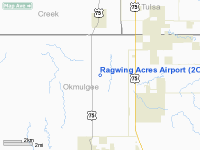
| From nearest city: | 3 nautical miles S of Mounds, OK |
| Location: | Okmulgee County, OK |
| Magnetic Variation: | 06E (1985) |
Owner & Manager
| Ownership: | Privately owned |
| Owner: | Dale Bunney |
| Address: | 7355 Ferguson Rd
Mounds, OK 74047-6159 |
| Phone number: | 918-827-6463 |
| Manager: | Dale Bunney |
| Address: | 7355 Ferguson Rd
Mounds, OK 74047-6159 |
| Phone number: | 918-827-6463 |
Airport Operations and Facilities
| Airport Use: | Private |
| Wind indicator: | Yes |
| Segmented Circle: | No |
| Control Tower: | No |
| Landing fee charge: | No |
| Sectional chart: | Dallas-ft Worth |
| Region: | ASW - Southwest |
| Boundary ARTCC: | ZFW - Fort Worth |
| Tie-in FSS: | MLC - Mc Alester |
| FSS on Airport: | No |
| FSS Toll Free: | 1-800-WX-BRIEF |
Airport Services
Runway Information
Runway 17/35
| Dimension: | 1325 x 75 ft / 403.9 x 22.9 m |
| Surface: | TURF, |
| |
Runway 17 |
Runway 35 |
| Traffic Pattern: | Left | Left |
| Obstruction: | 5 ft fence | 5 ft fence |
|
Radio Navigation Aids
| ID |
Type |
Name |
Ch |
Freq |
Var |
Dist |
| TZO | NDB | Bristow | | 251.00 | 05E | 18.1 nm |
| OWP | NDB | William Pogue | | 362.00 | 06E | 21.9 nm |
| HET | NDB | Henryetta | | 267.00 | 04E | 24.9 nm |
| DW | NDB | Owaso | | 375.00 | 06E | 30.8 nm |
| CUH | NDB | Cushing | | 242.00 | 05E | 35.2 nm |
| GGU | NDB | Prague | | 314.00 | 06E | 36.9 nm |
| CQB | NDB | Tilghman | | 396.00 | 06E | 37.5 nm |
| MKO | NDB | Muskogee | | 306.00 | 06E | 39.9 nm |
| SRE | NDB | Seminole | | 278.00 | 06E | 44.5 nm |
| HDL | NDB | Holdenville | | 411.00 | 06E | 47.3 nm |
| MEE | VOR | Davis | | 108.60 | 06E | 34.9 nm |
| GNP | VOR/DME | Glenpool | 043X | 110.60 | 06E | 7.6 nm |
| OKM | VOR/DME | Okmulgee | 096X | 114.90 | 08E | 12.0 nm |
| TUL | VORTAC | Tulsa | 091X | 114.40 | 08E | 26.3 nm |
| TUL | VOT | Tulsa Intl | | 109.00 | | 26.3 nm |
Remarks
Images and information placed above are from
http://www.airport-data.com/airport/2OK4/
We thank them for the data!
| General Info
|
| Country |
United States
|
| State |
OKLAHOMA
|
| FAA ID |
2OK4
|
| Latitude |
35-49-00.347N
|
| Longitude |
096-03-30.984W
|
| Elevation |
780 feet
|
| Near City |
MOUNDS
|
We don't guarantee the information is fresh and accurate. The data may
be wrong or outdated.
For more up-to-date information please refer to other sources.
|
|


