 |
|
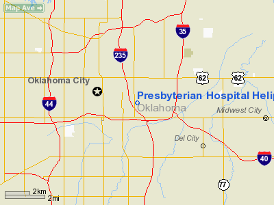
Presbyterian Hospital Heliport |
Location & QuickFacts
| FAA Information Effective: | 2008-09-25 |
| Airport Identifier: | 97OK |
| Airport Status: | Operational |
| Longitude/Latitude: | 097-30-01.1380W/35-28-29.2160N
-97.500316/35.474782 (Estimated) |
| Elevation: | 1262 ft / 384.66 m (Estimated) |
| Land: | 0 acres |
| From nearest city: | 0 nautical miles N of Oklahoma City, OK |
| Location: | Oklahoma County, OK |
| Magnetic Variation: | 07E (1985) |
Owner & Manager
| Ownership: | Privately owned |
| Owner: | Ou Medical Center |
| Address: | 700 Ne 13th St
Oklahoma City, OK 73104 |
| Phone number: | 405-271-7700 |
| Manager: | Marvin Mcclellan |
| Address: | 700 Ne 13th St
Oklahoma City, OK 73104 |
| Phone number: | 405-271-7700 |
Airport Operations and Facilities
| Airport Use: | Private
MEDICAL |
| Wind indicator: | Yes |
| Segmented Circle: | No |
| Control Tower: | No |
| Lighting Schedule: | PHONE REQ
FOR PERIMETER LGTS CALL 405-271-5100. |
| Sectional chart: | Dallas-ft Worth |
| Region: | ASW - Southwest |
| Boundary ARTCC: | ZFW - Fort Worth |
| Tie-in FSS: | MLC - Mc Alester |
| FSS Toll Free: | 1-800-WX-BRIEF |
Runway Information
Helipad H1
| Dimension: | 30 x 30 ft / 9.1 x 9.1 m |
| Surface: | CONC, |
| |
Runway H1 |
Runway |
| Traffic Pattern: | Left | Left |
|
Radio Navigation Aids
| ID |
Type |
Name |
Ch |
Freq |
Var |
Dist |
| OK | NDB | Tuloo | | 406.00 | 07E | 5.2 nm |
| OUN | NDB | Norman | | 260.00 | 07E | 13.7 nm |
| LCY | NDB | Logan County | | 326.00 | 07E | 22.7 nm |
| RQO | NDB | El Reno | | 335.00 | 07E | 24.9 nm |
| OLR | NDB | Chickasha | | 290.00 | 07E | 32.1 nm |
| CQB | NDB | Tilghman | | 396.00 | 06E | 36.5 nm |
| GGU | NDB | Prague | | 314.00 | 06E | 38.3 nm |
| SRE | NDB | Seminole | | 278.00 | 06E | 42.3 nm |
| CUH | NDB | Cushing | | 242.00 | 05E | 43.3 nm |
| PVJ | NDB | Pauls Valley | | 384.00 | 06E | 47.6 nm |
| TIK | TACAN | Tinker | 105X | | 07E | 6.3 nm |
| PWA | VOR/DME | Wiley Post | 081X | 113.40 | 08E | 8.0 nm |
| SWO | VOR/DME | Stillwater | 021X | 108.40 | 07E | 49.5 nm |
| IRW | VORTAC | Will Rogers | 088X | 114.10 | 07E | 8.8 nm |
| IFI | VORTAC | Kingfisher | 094X | 114.70 | 09E | 31.6 nm |
| OKC | VOT | Oklahoma Will Rgs W | | 108.80 | | 6.9 nm |
Remarks
- PRVDD 5 LGT POLES SURROUNDING HELIPAD ARE REMOVED; AND INGRESS/EGRESS ROUTES ARE FM/TO NW AND TO REMAIN WELL CLEAR OF THE 5 NORTHERN MOST LGT POLES.
Images and information placed above are from
http://www.airport-data.com/airport/97OK/
We thank them for the data!
| General Info
|
| Country |
United States
|
| State |
OKLAHOMA
|
| FAA ID |
97OK
|
| Latitude |
35-28-29.216N
|
| Longitude |
097-30-01.138W
|
| Elevation |
1262 feet
|
| Near City |
OKLAHOMA CITY
|
We don't guarantee the information is fresh and accurate. The data may
be wrong or outdated.
For more up-to-date information please refer to other sources.
|
|


