 |
|
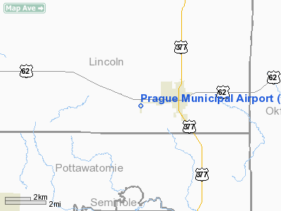
Location & QuickFacts
| FAA Information Effective: | 2008-09-25 |
| Airport Identifier: | O47 |
| Airport Status: | Operational |
| Longitude/Latitude: | 096-43-07.3200W/35-28-56.4650N
-96.718700/35.482351 (Estimated) |
| Elevation: | 1042 ft / 317.60 m (Estimated) |
| Land: | 62 acres |
| From nearest city: | 2 nautical miles W of Prague, OK |
| Location: | Lincoln County, OK |
| Magnetic Variation: | 06E (1995) |
Owner & Manager
| Ownership: | Publicly owned |
| Owner: | City Of Prague |
| Address: | City Hall
Prague, OK 74864 |
| Phone number: | 405-567-2279 |
| Manager: | Jim Greff
CITY MANAGER. |
| Address: | City Hall, 1116 N. Jim Thorpe Blvd.
Prague, OK 74864 |
| Phone number: | 405-567-2279 |
Airport Operations and Facilities
| Airport Use: | Open to public |
| Wind indicator: | Yes |
| Segmented Circle: | No |
| Control Tower: | No |
| Lighting Schedule: | DUSK-DAWN
MIRL RY 17/35 PRESET LOW INTST; TO INCR INTST ACTVT - CTAF. |
| Beacon Color: | Clear-Green (lighted land airport)
ROTG BCN OTS INDEFLY. |
| Landing fee charge: | No |
| Sectional chart: | Dallas-ft Worth |
| Region: | ASW - Southwest |
| Boundary ARTCC: | ZFW - Fort Worth |
| Tie-in FSS: | MLC - Mc Alester |
| FSS on Airport: | No |
| FSS Toll Free: | 1-800-WX-BRIEF |
| NOTAMs Facility: | MLC (NOTAM-d service avaliable) |
| Federal Agreements: | NGSY |
Airport Communications
Airport Services
| Airframe Repair: | NONE |
| Power Plant Repair: | NONE |
| Bottled Oxygen: | NONE |
| Bulk Oxygen: | NONE |
Runway Information
Runway 17/35
| Dimension: | 2757 x 60 ft / 840.3 x 18.3 m |
| Surface: | ASPH, Good Condition |
| Pavement Class: | 4 /F/C/Y/T |
| Weight Limit: | Single wheel: 4000 lbs. |
| Edge Lights: | Medium |
| |
Runway 17 |
Runway 35 |
| Longitude: | 096-43-07.2000W | 096-43-07.4400W |
| Latitude: | 35-29-10.1000N | 35-28-42.8300N |
| Elevation: | 1040.00 ft | 1015.00 ft |
| Alignment: | 127 | 0 |
| Traffic Pattern: | Left | Left |
| Markings: | Non-precision instrument, Good Condition | Basic, Good Condition |
| VASI: | 2-light PAPI on left side | 2-light PAPI on left side |
| Obstruction: | 15 ft road, 400.0 ft from runway, 13:1 slope to clear | , 50:1 slope to clear |
|
Radio Navigation Aids
| ID |
Type |
Name |
Ch |
Freq |
Var |
Dist |
| GGU | NDB | Prague | | 314.00 | 06E | 2.1 nm |
| SRE | NDB | Seminole | | 278.00 | 06E | 12.8 nm |
| CQB | NDB | Tilghman | | 396.00 | 06E | 15.2 nm |
| TZO | NDB | Bristow | | 251.00 | 05E | 22.5 nm |
| CUH | NDB | Cushing | | 242.00 | 05E | 24.7 nm |
| HDL | NDB | Holdenville | | 411.00 | 06E | 28.2 nm |
| HET | NDB | Henryetta | | 267.00 | 04E | 34.8 nm |
| OUN | NDB | Norman | | 260.00 | 07E | 39.4 nm |
| LCY | NDB | Logan County | | 326.00 | 07E | 40.4 nm |
| OK | NDB | Tuloo | | 406.00 | 07E | 43.4 nm |
| OWP | NDB | William Pogue | | 362.00 | 06E | 49.8 nm |
| TIK | TACAN | Tinker | 105X | | 07E | 32.5 nm |
| ADH | VOR/DME | Ada | 125X | 117.80 | 06E | 40.9 nm |
| OKM | VOR/DME | Okmulgee | 096X | 114.90 | 08E | 43.6 nm |
| GNP | VOR/DME | Glenpool | 043X | 110.60 | 06E | 45.1 nm |
| PWA | VOR/DME | Wiley Post | 081X | 113.40 | 08E | 45.5 nm |
| SWO | VOR/DME | Stillwater | 021X | 108.40 | 07E | 48.0 nm |
| IRW | VORTAC | Will Rogers | 088X | 114.10 | 07E | 44.3 nm |
| OKC | VOT | Oklahoma Will Rgs W | | 108.80 | | 43.5 nm |
Images and information placed above are from
http://www.airport-data.com/airport/O47/
We thank them for the data!
|
|


