 |
|
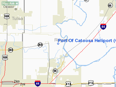
Location & QuickFacts
| FAA Information Effective: | 2008-09-25 |
| Airport Identifier: | O64 |
| Airport Status: | Operational |
| Longitude/Latitude: | 095-44-20.9400W/36-13-53.3500N
-95.739150/36.231486 (Estimated) |
| Elevation: | 601 ft / 183.18 m (Estimated) |
| Land: | 0 acres |
| From nearest city: | 3 nautical miles N of Catoosa, OK |
| Location: | Rogers County, OK |
| Magnetic Variation: | 06E (1990) |
Owner & Manager
| Ownership: | Publicly owned |
| Owner: | City Of Tulsa - Rogers County
PORT AUTHORITY. |
| Address: | 5350 Cimarron Rd
Catoosa, OK 74015 |
| Phone number: | 918-266-2291 |
| Manager: | Richard (dick) Voth
RICHARD (DICK) VOTH, DEPUTY DIRECTOR. |
| Address: | 5350 Cimarron Rd
Catoosa, OK 74015 |
| Phone number: | 918-266-2291 |
Airport Operations and Facilities
| Airport Use: | Open to public |
| Wind indicator: | Yes |
| Segmented Circle: | No |
| Control Tower: | No |
| Lighting Schedule: | DUSK-DAWN |
| Sectional chart: | Kansas City |
| Region: | ASW - Southwest |
| Boundary ARTCC: | ZKC - Kansas City |
| Tie-in FSS: | MLC - Mc Alester |
| FSS on Airport: | No |
| FSS Toll Free: | 1-800-WX-BRIEF |
| NOTAMs Facility: | MLC (NOTAM-d service avaliable) |
Airport Communications
Runway Information
Helipad H1
| Dimension: | 50 x 50 ft / 15.2 x 15.2 m |
| Surface: | CONC, Good Condition |
| |
Runway H1 |
Runway |
| Traffic Pattern: | Left | Left |
| Markings: | Basic, Good Condition | , |
|
Radio Navigation Aids
| ID |
Type |
Name |
Ch |
Freq |
Var |
Dist |
| DW | NDB | Owaso | | 375.00 | 06E | 8.0 nm |
| OWP | NDB | William Pogue | | 362.00 | 06E | 20.4 nm |
| TQH | NDB | Tahlequah | | 215.00 | 05E | 40.1 nm |
| TZO | NDB | Bristow | | 251.00 | 05E | 43.4 nm |
| MKO | NDB | Muskogee | | 306.00 | 06E | 44.1 nm |
| MEE | VOR | Davis | | 108.60 | 06E | 38.6 nm |
| GNP | VOR/DME | Glenpool | 043X | 110.60 | 06E | 21.7 nm |
| OKM | VOR/DME | Okmulgee | 096X | 114.90 | 08E | 32.9 nm |
| BVO | VOR/DME | Bartlesville | 126X | 117.90 | 08E | 38.7 nm |
| TUL | VORTAC | Tulsa | 091X | 114.40 | 08E | 3.2 nm |
| TUL | VOT | Tulsa Intl | | 109.00 | | 3.2 nm |
Images and information placed above are from
http://www.airport-data.com/airport/O64/
We thank them for the data!
| General Info
|
| Country |
United States
|
| State |
OKLAHOMA
|
| FAA ID |
O64
|
| Latitude |
36-13-53.350N
|
| Longitude |
095-44-20.940W
|
| Elevation |
601 feet
|
| Near City |
CATOOSA
|
We don't guarantee the information is fresh and accurate. The data may
be wrong or outdated.
For more up-to-date information please refer to other sources.
|
|


