|
|
| Ponca City Regional Airport |
 |
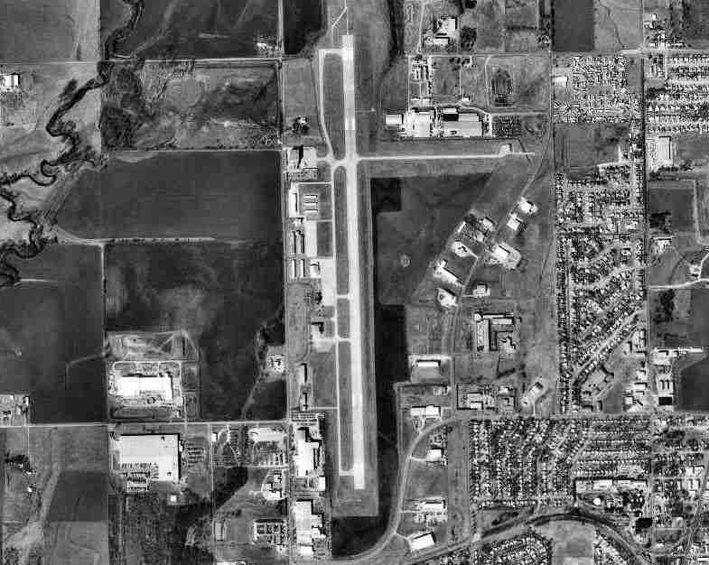
| USGS aerial image - 17 February 1995 |
| IATA: PNC – ICAO: KPNC – FAA LID: PNC |
| Summary |
| Airport type |
Public |
| Owner |
City of Ponca City |
| Serves |
Ponca City, Oklahoma |
| Elevation AMSL |
1,008 ft / 307 m |
| Coordinates |
36°43′55″N 097°05′59″W / 36.73194°N 97.09972°W / 36.73194; -97.09972Coordinates: 36°43′55″N 097°05′59″W / 36.73194°N 97.09972°W / 36.73194; -97.09972 |
| Runways |
| Direction |
Length |
Surface |
| ft |
m |
| 17/35 |
7,201 |
2,195 |
Concrete |
| Statistics (2008) |
| Aircraft operations |
61,500 |
| Based aircraft |
64 |
| Source: Federal Aviation Administration |
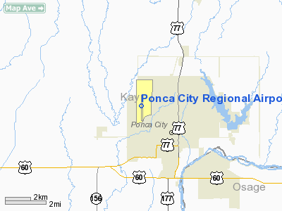
Ponca City Regional Airport (IATA: PNC, ICAO: KPNC, FAA LID: PNC) is a city-owned, public-use airport located two nautical miles (3.7 km) northwest of the central business district of Ponca City, in Kay County, Oklahoma, United States. It is mostly used for general aviation. Enrique's is a well known Mexican restaurant located in the terminal.
Scheduled passenger flights on Great Lakes Airlines to Denver and Dodge City were discontinued in August, 2006. The service was subsidized by the Essential Air Service program. History
The airport was opened during November 1938 with a single 3,600' concrete runway. In the summer of 1941, the facility was taken over by the United States Army Air Force and was used initially as part of the British Flying Training School program. This training was performed as part of the Lend-Lease act where Royal Air Force (RAF) flying cadets were provided a 20-week basic flying course taught by civil contractors. Flight training was provided by the Darr School of Aeronautics, Fairchild PT-19s were the primary trainer at the airfield. Also had several PT-17 Stearmans and a few P-40 Warhawks assigned.
In November 1942, RAF training ended at Miami and the airfield became a primary (stage 1) pilot training airfield assigned to AAF Flying Training Command, Gulf Coast Training Center (later Central Flying Training Command). The civil instructors were retained under USAAF control by the 323d Flying Training Detachment.
Pilot training at the airfield apparently ended on 30 May 1944, with the reduced demand for new pilots. The airfield was then returned to the local government at the end of the war.
Facilities and aircraft
Ponca City Regional Airport covers an area of 500 acres (202 ha) at an elevation of 1,008 feet (307 m) above mean sea level. It has one runway designated 17/35 with a concrete surface measuring 7,201 by 150 feet (2,195 x 46 m).
For the 12-month period ending August 26, 2008, the airport had 61,500 aircraft operations, an average of 168 per day: 93% general aviation and 7% military. At that time there were 64 aircraft based at this airport: 91% single-engine, 5% multi-engine, 3% jet and 2% ultralight.
The above content comes from Wikipedia and is published under free licenses – click here to read more.
Location & QuickFacts
| FAA Information Effective: | 2008-09-25 |
| Airport Identifier: | PNC |
| Airport Status: | Operational |
| Longitude/Latitude: | 097-05-59.2000W/36-43-54.9000N
-97.099778/36.731917 (Estimated) |
| Elevation: | 1008 ft / 307.24 m (Surveyed) |
| Land: | 500 acres |
| From nearest city: | 2 nautical miles NW of Ponca City, OK |
| Location: | Kay County, OK |
| Magnetic Variation: | 05E (2005) |
Owner & Manager
| Ownership: | Publicly owned |
| Owner: | City Of Ponca City |
| Address: | Box 1450
Ponca City, OK 74602 |
| Phone number: | 580-767-0300 |
| Manager: | Don Nuzum |
| Address: | Box 1450
Ponca City, OK 74602 |
| Phone number: | 580-767-0470 |
Airport Operations and Facilities
| Airport Use: | Open to public |
| Wind indicator: | Yes |
| Segmented Circle: | Yes |
| Control Tower: | No |
| Lighting Schedule: | DUSK-DAWN
ACTVT HIRL RY 17/35; MALSR RY 17, REIL RY 35, PAPI RYS 17 & 35 - CTAF. |
| Beacon Color: | Clear-Green (lighted land airport) |
| Landing fee charge: | No |
| Sectional chart: | Wichita |
| Region: | ASW - Southwest |
| Traffic Pattern Alt: | 993 ft |
| Boundary ARTCC: | ZKC - Kansas City |
| Tie-in FSS: | MLC - Mc Alester |
| FSS on Airport: | No |
| FSS Toll Free: | 1-800-WX-BRIEF |
| NOTAMs Facility: | PNC (NOTAM-d service avaliable) |
| Federal Agreements: | NGPY |
Airport Communications
| CTAF: | 123.000 |
| Unicom: | 123.000 |
Airport Services
| Fuel available: | 100LLA
JET A FUEL & SVC AVBL 0700-DUSK; OTHER TIMES CALL 580-762-8647. 100LL FUEL AVBL 24 HRS. |
| Airframe Repair: | MAJOR |
| Power Plant Repair: | MAJOR |
| Bottled Oxygen: | LOW |
| Bulk Oxygen: | NONE |
Runway Information
Runway 17/35
| Dimension: | 7201 x 150 ft / 2194.9 x 45.7 m |
| Surface: | CONC, Good Condition |
| Surface Treatment: | Saw-cut or plastic Grooved
NORTH 2400 FT OF RY NSTD PLASTIC GROOVING ENTIRE WIDTH & 25 FT EACH EDGE AT REMAINDER OF RY (4801 FT). |
| Weight Limit: | Single wheel: 51000 lbs.
Dual wheel: 65000 lbs.
Dual tandem wheel: 122000 lbs. |
| Edge Lights: | High |
| |
Runway 17 |
Runway 35 |
| Longitude: | 097-05-59.5018W | 097-05-58.9312W |
| Latitude: | 36-44-30.6360N | 36-43-19.4375N |
| Elevation: | 994.00 ft | 1006.00 ft |
| Alignment: | 127 | 127 |
| ILS Type: | ILS/DME
| |
| Traffic Pattern: | Right | Left |
| Markings: | Precision instrument, Good Condition | Precision instrument, Good Condition |
| Crossing Height: | 49.00 ft | 0.00 ft |
| VASI: | 4-light PAPI on right side | 4-light PAPI on right side |
| Visual Glide Angle: | 3.00° | 0.00° |
| Approach lights: | MALSR | |
| Runway End Identifier: | | Yes |
| Obstruction: | , 50:1 slope to clear | 28 ft bldg, 710.0 ft from runway, 555 ft left of centerline, 18:1 slope to clear |
|
Radio Navigation Aids
| ID |
Type |
Name |
Ch |
Freq |
Var |
Dist |
| PN | NDB | Ponca | | 515.00 | 05E | 5.6 nm |
| EGT | NDB | Wellington | | 414.00 | 07E | 38.2 nm |
| SWO | VOR/DME | Stillwater | 021X | 108.40 | 07E | 30.5 nm |
| ODG | VOR/DME | Woodring | 027X | 109.00 | 08E | 39.6 nm |
| PER | VORTAC | Pioneer | 079X | 113.20 | 06E | 3.0 nm |
| END | VORTAC | Vance | 101X | 115.40 | 09E | 45.9 nm |
Remarks
- TWY A LGTS OTS INDEFLY.
- ESTABLISHED PRIOR TO 1958.
Images and information placed above are from
http://www.airport-data.com/airport/PNC/
We thank them for the data!
| General Info
|
| Country |
United States
|
| State |
OKLAHOMA
|
| FAA ID |
PNC
|
| Latitude |
36-43-50.103N
|
| Longitude |
097-05-59.166W
|
| Elevation |
1007 feet
|
| Near City |
PONCA CITY
|
We don't guarantee the information is fresh and accurate. The data may
be wrong or outdated.
For more up-to-date information please refer to other sources.
|
|