 |
|
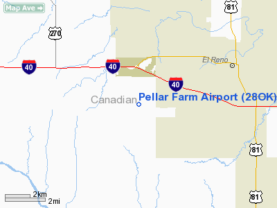
Location & QuickFacts
| FAA Information Effective: | 2008-09-25 |
| Airport Identifier: | 28OK |
| Airport Status: | Operational |
| Longitude/Latitude: | 098-02-26.1850W/35-30-10.1870N
-98.040607/35.502830 (Estimated) |
| Elevation: | 1400 ft / 426.72 m (Estimated) |
| Land: | 0 acres |
| From nearest city: | 4 nautical miles W of El Reno, OK |
| Location: | Canadian County, OK |
| Magnetic Variation: | 07E (1985) |
Owner & Manager
| Ownership: | Privately owned |
| Owner: | Larry G. Pellar |
| Address: | Rr 2 Box 207
El Reno, OK 73036 |
| Phone number: | 405-262-4433 |
| Address: |
|
Airport Operations and Facilities
| Airport Use: | Private |
| Wind indicator: | Yes |
| Segmented Circle: | No |
| Control Tower: | No |
| Sectional chart: | Dallas-ft Worth |
| Region: | ASW - Southwest |
| Boundary ARTCC: | ZFW - Fort Worth |
| Tie-in FSS: | MLC - Mc Alester |
| FSS Toll Free: | 1-800-WX-BRIEF |
Runway Information
Runway 17/35
| Dimension: | 2300 x 125 ft / 701.0 x 38.1 m |
| Surface: | TURF, |
| |
Runway 17 |
Runway 35 |
| Traffic Pattern: | Left | Right |
|
Radio Navigation Aids
| ID |
Type |
Name |
Ch |
Freq |
Var |
Dist |
| FSI | FAN MARKER | Trail | | | 09E | 46.9 nm |
| RQO | NDB | El Reno | | 335.00 | 07E | 2.1 nm |
| OK | NDB | Tuloo | | 406.00 | 07E | 21.4 nm |
| OLR | NDB | Chickasha | | 290.00 | 07E | 24.2 nm |
| JWG | NDB | Watonga | | 359.00 | 07E | 28.6 nm |
| OJA | NDB | Weatherford | | 272.00 | 07E | 30.9 nm |
| OUN | NDB | Norman | | 260.00 | 07E | 31.9 nm |
| LCY | NDB | Logan County | | 326.00 | 07E | 36.8 nm |
| CLK | NDB | Clinton | | 320.00 | 07E | 43.8 nm |
| OFZ | NDB | Trail | | 388.00 | 09E | 46.9 nm |
| TIK | TACAN | Tinker | 105X | | 07E | 32.6 nm |
| PWA | VOR/DME | Wiley Post | 081X | 113.40 | 08E | 19.3 nm |
| IFI | VORTAC | Kingfisher | 094X | 114.70 | 09E | 18.3 nm |
| IRW | VORTAC | Will Rogers | 088X | 114.10 | 07E | 22.8 nm |
| OKC | VOT | Oklahoma Will Rgs W | | 108.80 | | 22.6 nm |
Remarks
- POND ON NORTH END OF RWY 17/35.
- PERSONAL USE ONLY; AGREEMENT WITH BRANDLEY ARPT TO SHARE THE SAME AIRSPACE.
Images and information placed above are from
http://www.airport-data.com/airport/28OK/
We thank them for the data!
| General Info
|
| Country |
United States
|
| State |
OKLAHOMA
|
| FAA ID |
28OK
|
| Latitude |
35-30-10.187N
|
| Longitude |
098-02-26.185W
|
| Elevation |
1400 feet
|
| Near City |
EL RENO
|
We don't guarantee the information is fresh and accurate. The data may
be wrong or outdated.
For more up-to-date information please refer to other sources.
|
|


