 |
|
Location & QuickFacts
| FAA Information Effective: | 2008-09-25 |
| Airport Identifier: | H66 |
| Airport Status: | Operational |
| Longitude/Latitude: | 095-37-30.9210W/36-43-15.3200N
-95.625256/36.720922 (Estimated) |
| Elevation: | 679 ft / 206.96 m (Surveyed) |
| Land: | 100 acres |
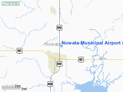
| From nearest city: | 2 nautical miles NE of Nowata, OK |
| Location: | Nowata County, OK |
| Magnetic Variation: | 06E (1985) |
Owner & Manager
| Ownership: | Publicly owned |
| Owner: | City Of Nowata |
| Address: | 701 E Modoc
Nowata, OK 74048 |
| Phone number: | 918-273-3538 |
| Manager: | Fred Maddox |
| Address: | 332 N Shawnee Ct
Nowata, OK 74048 |
| Phone number: | 918-273-1605 |
Airport Operations and Facilities
| Airport Use: | Open to public |
| Wind indicator: | Yes |
| Segmented Circle: | Yes |
| Control Tower: | No |
| Landing fee charge: | No |
| Sectional chart: | Kansas City |
| Region: | ASW - Southwest |
| Boundary ARTCC: | ZKC - Kansas City |
| Tie-in FSS: | MLC - Mc Alester |
| FSS on Airport: | No |
| FSS Toll Free: | 1-800-WX-BRIEF |
| NOTAMs Facility: | MLC (NOTAM-d service avaliable) |
| Federal Agreements: | GY |
Airport Communications
Airport Services
| Airframe Repair: | NONE |
| Power Plant Repair: | NONE |
| Bottled Oxygen: | NONE |
| Bulk Oxygen: | NONE |
Runway Information
Runway 05/23
| Dimension: | 2440 x 45 ft / 743.7 x 13.7 m |
| Surface: | TURF, Poor Condition
RY EXTREMELY ROUGH & COVERED WITH TALL GRASS.
RY SFC ROUGH & UNEVEN. |
| |
Runway 05 |
Runway 23 |
| Traffic Pattern: | Left | Left |
| Obstruction: | 45 ft pline, 650.0 ft from runway, 14:1 slope to clear | 60 ft trees, 700.0 ft from runway, 11:1 slope to clear |
|
Runway 17/35
| Dimension: | 2500 x 45 ft / 762.0 x 13.7 m |
| Surface: | ASPH, Poor Condition
RY EXTREMELY ROUGH & COVERED WITH TALL GRASS.
RY SFC ROUGH & UNEVEN. |
| Weight Limit: | Single wheel: 4000 lbs. |
| |
Runway 17 |
Runway 35 |
| Traffic Pattern: | Left | Left |
| Markings: | Basic, Good Condition
RY 17/35 MARKINGS DETERIORATED OR PARTIALLY COVERED BY ASPH PATCHING. | Basic, Poor Condition
RY END MARKINGS DETERIORATED OR PARTIALLY COVERED BY ASPH PATCHING. |
| Obstruction: | 35 ft pline, 900.0 ft from runway, 20:1 slope to clear | 20 ft trees, 288.0 ft from runway, 4:1 slope to clear |
|
Radio Navigation Aids
| ID |
Type |
Name |
Ch |
Freq |
Var |
Dist |
| CFV | NDB | Coffeyville | | 212.00 | 05E | 22.5 nm |
| DW | NDB | Owaso | | 375.00 | 06E | 27.6 nm |
| PPF | NDB | Parsons | | 258.00 | 06E | 37.5 nm |
| OWP | NDB | William Pogue | | 362.00 | 06E | 41.7 nm |
| BVO | VOR/DME | Bartlesville | 126X | 117.90 | 08E | 20.1 nm |
| TUL | VORTAC | Tulsa | 091X | 114.40 | 08E | 32.5 nm |
| OSW | VORTAC | Oswego | 123X | 117.60 | 08E | 33.2 nm |
| TUL | VOT | Tulsa Intl | | 109.00 | | 32.5 nm |
Remarks
- -2 FT DITCH AT RY 23 THLD; -12 FT DITCH 220 FT FM RY 35 THLD.
Images and information placed above are from
http://www.airport-data.com/airport/H66/
We thank them for the data!
| General Info
|
| Country |
United States
|
| State |
OKLAHOMA
|
| FAA ID |
H66
|
| Latitude |
36-43-15.320N
|
| Longitude |
095-37-30.921W
|
| Elevation |
679 feet
|
| Near City |
NOWATA
|
We don't guarantee the information is fresh and accurate. The data may
be wrong or outdated.
For more up-to-date information please refer to other sources.
|
|


