 |
|
Location & QuickFacts
| FAA Information Effective: | 2008-09-25 |
| Airport Identifier: | OL12 |
| Airport Status: | Operational |
| Longitude/Latitude: | 097-32-26.1500W/35-42-27.1850N
-97.540597/35.707551 (Estimated) |
| Elevation: | 1070 ft / 326.14 m (Estimated) |
| Land: | 0 acres |
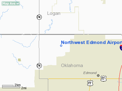
| From nearest city: | 3 nautical miles NW of Edmond, OK |
| Location: | Oklahoma County, OK |
| Magnetic Variation: | 07E (1985) |
Owner & Manager
| Ownership: | Privately owned |
| Owner: | Ranger Land Corporation |
| Address: | 107 South Broadway
Edmond, OK 73034 |
| Phone number: | 405-341-1779X19 |
| Manager: | J. T. Hoke, Jr. |
| Address: | 107 South Broadway
Edmond, OK 73034 |
| Phone number: | 405-341-1779X19 |
Airport Operations and Facilities
| Airport Use: | Private |
| Segmented Circle: | No |
| Control Tower: | No |
| Sectional chart: | Dallas-ft Worth |
| Region: | ASW - Southwest |
| Boundary ARTCC: | ZKC - Kansas City |
| Responsible ARTCC: | ZFW - Fort Worth |
| Tie-in FSS: | MLC - Mc Alester |
| FSS Toll Free: | 1-800-WX-BRIEF |
Runway Information
Runway 17/35
| Dimension: | 2000 x 30 ft / 609.6 x 9.1 m |
| Surface: | TURF, |
| |
Runway 17 |
Runway 35 |
| Traffic Pattern: | Left | Left |
|
Radio Navigation Aids
| ID |
Type |
Name |
Ch |
Freq |
Var |
Dist |
| LCY | NDB | Logan County | | 326.00 | 07E | 10.3 nm |
| OK | NDB | Tuloo | | 406.00 | 07E | 14.5 nm |
| RQO | NDB | El Reno | | 335.00 | 07E | 26.7 nm |
| OUN | NDB | Norman | | 260.00 | 07E | 27.8 nm |
| CQB | NDB | Tilghman | | 396.00 | 06E | 35.2 nm |
| CUH | NDB | Cushing | | 242.00 | 05E | 38.9 nm |
| GGU | NDB | Prague | | 314.00 | 06E | 41.8 nm |
| OLR | NDB | Chickasha | | 290.00 | 07E | 42.0 nm |
| JWG | NDB | Watonga | | 359.00 | 07E | 44.1 nm |
| SRE | NDB | Seminole | | 278.00 | 06E | 49.8 nm |
| TIK | TACAN | Tinker | 105X | | 07E | 18.1 nm |
| PWA | VOR/DME | Wiley Post | 081X | 113.40 | 08E | 11.7 nm |
| SWO | VOR/DME | Stillwater | 021X | 108.40 | 07E | 38.3 nm |
| ODG | VOR/DME | Woodring | 027X | 109.00 | 08E | 41.8 nm |
| IRW | VORTAC | Will Rogers | 088X | 114.10 | 07E | 21.2 nm |
| IFI | VORTAC | Kingfisher | 094X | 114.70 | 09E | 23.4 nm |
| END | VORTAC | Vance | 101X | 115.40 | 09E | 42.5 nm |
| OKC | VOT | Oklahoma Will Rgs W | | 108.80 | | 19.1 nm |
Remarks
- PRVDD PROCEDURES ARE ESTABLISHED WITH OWNER OF WAKEFIELD ARPT TO ASSURE FLIGHT OPERATIONS DO NOT CONFLICT W/WAKEFIELD ARPT TFC PTN OPNS.
Images and information placed above are from
http://www.airport-data.com/airport/OL12/
We thank them for the data!
| General Info
|
| Country |
United States
|
| State |
OKLAHOMA
|
| FAA ID |
OL12
|
| Latitude |
35-42-27.185N
|
| Longitude |
097-32-26.150W
|
| Elevation |
1070 feet
|
| Near City |
EDMOND
|
We don't guarantee the information is fresh and accurate. The data may
be wrong or outdated.
For more up-to-date information please refer to other sources.
|
|


