 |
|
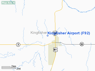
Location & QuickFacts
| FAA Information Effective: | 2008-09-25 |
| Airport Identifier: | F92 |
| Airport Status: | Operational |
| Longitude/Latitude: | 097-57-08.9000W/35-52-30.4000N
-97.952472/35.875111 (Estimated) |
| Elevation: | 1067 ft / 325.22 m (Estimated) |
| Land: | 44 acres |
| From nearest city: | 1 nautical miles NW of Kingfisher, OK |
| Location: | Kingfisher County, OK |
| Magnetic Variation: | 07E (1985) |
Owner & Manager
| Ownership: | Publicly owned |
| Owner: | City Of Kingfisher |
| Address: | 301 N. Main Street
Kingfisher, OK 73750 |
| Phone number: | 405-375-3705 |
| Manager: | Mike Brooks |
| Address: | 301 N. Main Street
Kingfisher, OK 73750 |
| Phone number: | 405-375-4901 |
Airport Operations and Facilities
| Airport Use: | Open to public |
| Wind indicator: | Yes
WIND INDICATOR MKD BY ORANGE/WHITE BARRELS IN SEMI CIRCLE. |
| Segmented Circle: | No |
| Control Tower: | No |
| Landing fee charge: | No |
| Sectional chart: | Dallas-ft Worth |
| Region: | ASW - Southwest |
| Boundary ARTCC: | ZFW - Fort Worth |
| Tie-in FSS: | MLC - Mc Alester |
| FSS on Airport: | No |
| FSS Toll Free: | 1-800-WX-BRIEF |
| NOTAMs Facility: | MLC (NOTAM-d service avaliable) |
Airport Communications
Airport Services
| Fuel available: | 100LL
AUTOMATED CREDIT CARD FUEL SYSTEM. |
Runway Information
Runway 17/35
| Dimension: | 2580 x 375 ft / 786.4 x 114.3 m |
| Surface: | TURF, Good Condition |
| |
Runway 17 |
Runway 35 |
| Longitude: | 097-57-09.1000W | 097-57-08.6100W |
| Latitude: | 35-52-43.1800N | 35-52-17.6700N |
| Traffic Pattern: | Left | Right |
| Obstruction: | 4 ft fence | 15 ft road, 35.0 ft from runway, 2:1 slope to clear |
|
Radio Navigation Aids
| ID |
Type |
Name |
Ch |
Freq |
Var |
Dist |
| JWG | NDB | Watonga | | 359.00 | 07E | 23.0 nm |
| RQO | NDB | El Reno | | 335.00 | 07E | 24.0 nm |
| LCY | NDB | Logan County | | 326.00 | 07E | 26.2 nm |
| OK | NDB | Tuloo | | 406.00 | 07E | 29.6 nm |
| FAU | NDB | Fairview | | 246.00 | 07E | 35.5 nm |
| OJA | NDB | Weatherford | | 272.00 | 07E | 40.7 nm |
| OUN | NDB | Norman | | 260.00 | 07E | 44.5 nm |
| OLR | NDB | Chickasha | | 290.00 | 07E | 46.3 nm |
| TIK | TACAN | Tinker | 105X | | 07E | 38.4 nm |
| PWA | VOR/DME | Wiley Post | 081X | 113.40 | 08E | 25.4 nm |
| ODG | VOR/DME | Woodring | 027X | 109.00 | 08E | 31.0 nm |
| SWO | VOR/DME | Stillwater | 021X | 108.40 | 07E | 47.3 nm |
| IFI | VORTAC | Kingfisher | 094X | 114.70 | 09E | 4.9 nm |
| END | VORTAC | Vance | 101X | 115.40 | 09E | 28.3 nm |
| IRW | VORTAC | Will Rogers | 088X | 114.10 | 07E | 35.3 nm |
| OKC | VOT | Oklahoma Will Rgs W | | 108.80 | | 33.7 nm |
Images and information placed above are from
http://www.airport-data.com/airport/F92/
We thank them for the data!
| General Info
|
| Country |
United States
|
| State |
OKLAHOMA
|
| FAA ID |
F92
|
| Latitude |
35-52-30.153N
|
| Longitude |
097-57-01.195W
|
| Elevation |
1067 feet
|
| Near City |
KINGFISHER
|
We don't guarantee the information is fresh and accurate. The data may
be wrong or outdated.
For more up-to-date information please refer to other sources.
|
|


