 |
|
Coordinates: 34°59′29″N 099°03′05″W / 34.99139°N 99.05139°W / 34.99139; -99.05139
| Hobart Municipal Airport |
| IATA: HBR – ICAO: KHBR – FAA LID: HBR |
| Summary |
| Airport type |
Public |
| Owner |
City of Hobart |
| Serves |
Hobart, Oklahoma |
| Elevation AMSL |
1,564 ft / 477 m |
| Runways |
| Direction |
Length |
Surface |
| ft |
m |
| 3/21 |
5,293 |
1,613 |
Asphalt |
| 12/30 |
5,293 |
1,613 |
Asphalt |
| 17/35 |
5,507 |
1,679 |
Asphalt |
| Source: Federal Aviation Administration |
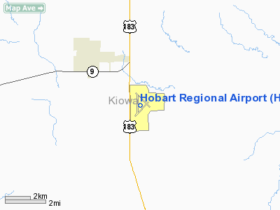
Hobart Municipal Airport (IATA: HBR, ICAO: KHBR, FAA LID: HBR) is a public airport located three miles (5 km) southeast of the central business district of Hobart, a city in Kiowa County, Oklahoma, United States. It is owned by the City of Hobart.
Facilities
Hobart Municipal Airport covers an area of 1,119 acres (453 ha) which contains three asphalt paved runways: 3/21 and 12/30 both measure 5,293 x 150 ft (1,613 x 46 m) and 17/35 measures 5,507 x 100 ft (1,679 x 30 m).
The above content comes from Wikipedia and is published under free licenses – click here to read more.
Location & QuickFacts
| FAA Information Effective: | 2008-09-25 |
| Airport Identifier: | HBR |
| Airport Status: | Operational |
| Longitude/Latitude: | 099-03-05.0000W/34-59-28.7000N
-99.051389/34.991306 (Estimated) |
| Elevation: | 1563 ft / 476.40 m (Surveyed) |
| Land: | 1119 acres |
| From nearest city: | 3 nautical miles SE of Hobart, OK |
| Location: | Kiowa County, OK |
| Magnetic Variation: | 07E (2000) |
Owner & Manager
| Ownership: | Publicly owned |
| Owner: | City Of Hobart |
| Address: | Po Box 231
Hobart, OK 73651 |
| Phone number: | 580-726-3881 |
| Manager: | Skeet Fixico |
| Address: | Route 1 Box 101
Hobart, OK 73651 |
| Phone number: | 580-726-2719 |
Airport Operations and Facilities
| Airport Use: | Open to public |
| Wind indicator: | Yes |
| Segmented Circle: | Yes |
| Control Tower: | No |
| Lighting Schedule: | DUSK-DAWN
ACTVT MIRL RY 17/35 - CTAF. |
| Beacon Color: | Clear-Green (lighted land airport) |
| Landing fee charge: | No |
| Sectional chart: | Dallas-ft Worth |
| Region: | ASW - Southwest |
| Boundary ARTCC: | ZFW - Fort Worth |
| Tie-in FSS: | MLC - Mc Alester |
| FSS on Airport: | No |
| FSS Toll Free: | 1-800-WX-BRIEF |
| NOTAMs Facility: | HBR (NOTAM-d service avaliable) |
| Federal Agreements: | NGPY3 |
Airport Communications
| CTAF: | 122.800 |
| Unicom: | 122.800 |
Airport Services
| Fuel available: | 100LLA
FUEL AVBL 24 HR SELF SERVICE WITH MAJOR CREDIT CARD. |
| Bottled Oxygen: | NONE |
| Bulk Oxygen: | NONE |
Runway Information
Runway 03/21
| Dimension: | 5297 x 150 ft / 1614.5 x 45.7 m |
| Surface: | ASPH, Poor Condition
RY ROUGH DUE TO SEVERE CRACKING & GRASS ENCROACHMENT ON SFC.
RY ROUGH DUE TO SEVERE CRACKING & GRASS ON SFC. |
| Pavement Class: | 2 /F/D/Z/U |
| Weight Limit: | Single wheel: 9400 lbs. |
| |
Runway 03 |
Runway 21 |
| Longitude: | 099-03-21.9892W | 099-02-36.8705W |
| Latitude: | 34-58-58.0736N | 34-59-35.0271N |
| Elevation: | 1563.00 ft | 1543.00 ft |
| Alignment: | 45 | 127 |
| Traffic Pattern: | Left | Left |
| Markings: | Numbers only, Poor Condition
RY END MARKINGS OBSCURED BY GRASS AND SEVERELY FADED. | Numbers only, Poor Condition
RY END MARKINGS OBSCURED BY GRASS AND SEVERELY FADED. |
|
Runway 12/30
| Dimension: | 5295 x 150 ft / 1613.9 x 45.7 m |
| Surface: | ASPH, Poor Condition
RY ROUGH DUE TO SEVERE CRACKING & GRASS ENCROACHMENT ON SFC.
RY ROUGH DUE TO SEVERE CRACKING & GRASS ON SFC. |
| Pavement Class: | 2 /F/D/Z/U |
| Weight Limit: | Single wheel: 9400 lbs. |
| |
Runway 12 |
Runway 30 |
| Longitude: | 099-03-21.6962W | 099-02-36.9093W |
| Latitude: | 34-59-59.3472N | 34-59-22.1457N |
| Elevation: | 1539.00 ft | 1540.00 ft |
| Alignment: | 127 | 127 |
| Traffic Pattern: | Left | Left |
| Markings: | Numbers only, Poor Condition
RY END MARKINGS OBSCURED BY GRASS AND SEVERELY FADED. | Numbers only, Poor Condition
RY END MARKINGS OBSCURED BY GRASS AND SEVERELY FADED. |
|
Runway 17/35
| Dimension: | 5507 x 100 ft / 1678.5 x 30.5 m |
| Surface: | ASPH, Good Condition
RY ROUGH DUE TO SEVERE CRACKING & GRASS ENCROACHMENT ON SFC.
RY ROUGH DUE TO SEVERE CRACKING & GRASS ON SFC. |
| Pavement Class: | 4 /F/B/X/T |
| Weight Limit: | Single wheel: 20000 lbs. |
| Edge Lights: | Medium |
| |
Runway 17 |
Runway 35 |
| Longitude: | 099-03-15.7724W | 099-03-16.0394W |
| Latitude: | 34-59-55.8994N | 34-59-01.4397N |
| Elevation: | 1540.00 ft | 1561.00 ft |
| Alignment: | 127 | 127 |
| Traffic Pattern: | Left | Left |
| Markings: | Non-precision instrument, Good Condition | Non-precision instrument, Good Condition |
| Crossing Height: | 35.00 ft | 42.00 ft |
| VASI: | 4-light PAPI on left side | 4-light PAPI on left side |
| Visual Glide Angle: | 3.00° | 3.00° |
| Obstruction: | 10 ft road, 565.0 ft from runway, 36:1 slope to clear | , 50:1 slope to clear |
|
Radio Navigation Aids
| ID |
Type |
Name |
Ch |
Freq |
Var |
Dist |
| FSI | FAN MARKER | Trail | | | 09E | 34.4 nm |
| BZ | NDB | Fossi | | 393.00 | 08E | 28.6 nm |
| EZY | NDB | Elk City | | 241.00 | 08E | 31.2 nm |
| CLK | NDB | Clinton | | 320.00 | 07E | 33.4 nm |
| OFZ | NDB | Trail | | 388.00 | 09E | 34.4 nm |
| OJA | NDB | Weatherford | | 272.00 | 07E | 37.4 nm |
| PFL | NDB | Post | | 308.00 | 08E | 39.4 nm |
| VRT | NDB | Wilbarger | | 230.00 | 08E | 47.4 nm |
| LAW | VOR/DME | Lawton | 031X | 109.40 | 09E | 43.4 nm |
| HBR | VORTAC | Hobart | 055X | 111.80 | 10E | 7.5 nm |
| BFV | VORTAC | Burns Flat | 037X | 110.00 | 08E | 16.6 nm |
| LTS | VORTAC | Altus | 035X | 109.80 | 08E | 22.5 nm |
| SYO | VORTAC | Sayre | 099X | 115.20 | 10E | 35.7 nm |
Remarks
Images and information placed above are from
http://www.airport-data.com/airport/HBR/
We thank them for the data!
| General Info
|
| Country |
United States
|
| State |
OKLAHOMA
|
| FAA ID |
HBR
|
| Latitude |
34-59-28.707N
|
| Longitude |
099-03-04.869W
|
| Elevation |
1564 feet
|
| Near City |
HOBART
|
We don't guarantee the information is fresh and accurate. The data may
be wrong or outdated.
For more up-to-date information please refer to other sources.
|
|


