 |
|
Location & QuickFacts
| FAA Information Effective: | 2008-09-25 |
| Airport Identifier: | 2O8 |
| Airport Status: | Operational |
| Longitude/Latitude: | 098-20-33.2280W/35-30-25.9700N
-98.342563/35.507214 (Estimated) |
| Elevation: | 1587 ft / 483.72 m (Estimated) |
| Land: | 80 acres |
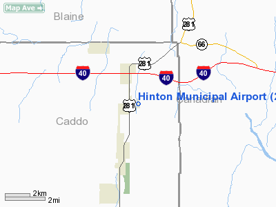
| From nearest city: | 2 nautical miles NE of Hinton, OK |
| Location: | Caddo County, OK |
| Magnetic Variation: | 07E (1995) |
Owner & Manager
| Ownership: | Publicly owned |
| Owner: | Town Of Hinton |
| Address: | Po Box 159
Hinton, OK 73047 |
| Phone number: | 405-542-3253 |
| Manager: | Steve Guest
FBO/AMGR. |
| Address: | Po Box 67
Hinton, OK 73047 |
| Phone number: | 405-542-3993
GUESTAIR 405-457-6500. |
Airport Operations and Facilities
| Airport Use: | Open to public |
| Wind indicator: | Yes |
| Segmented Circle: | Yes |
| Control Tower: | No |
| Lighting Schedule: | DUSK-DAWN |
| Beacon Color: | Clear-Green (lighted land airport) |
| Sectional chart: | Dallas-ft Worth |
| Region: | ASW - Southwest |
| Boundary ARTCC: | ZFW - Fort Worth |
| Tie-in FSS: | MLC - Mc Alester |
| FSS on Airport: | No |
| FSS Toll Free: | 1-800-WX-BRIEF |
| NOTAMs Facility: | MLC (NOTAM-d service avaliable) |
| Federal Agreements: | NGY |
Airport Communications
| CTAF: | 123.050 |
| Unicom: | 123.050 |
Airport Services
| Fuel available: | 100LL
FUEL AVBL 24 HRS WITH AUTOMATED CREDIT CARD SYSTEM. |
Runway Information
Runway 17/35
| Dimension: | 4000 x 60 ft / 1219.2 x 18.3 m |
| Surface: | ASPH, Fair Condition |
| Pavement Class: | 3 /F/B/Y/T |
| Edge Lights: | Medium |
| |
Runway 17 |
Runway 35 |
| Longitude: | 098-20-33.4360W | 098-20-33.0200W |
| Latitude: | 35-30-45.7530N | 35-30-06.1870N |
| Elevation: | 1577.00 ft | 1587.00 ft |
| Alignment: | 127 | 127 |
| Traffic Pattern: | Left | Left |
| Markings: | Non-precision instrument, Poor Condition
RY MARKINGS SEVERELY FADED. | Non-precision instrument, Poor Condition
RY MARKINGS SEVERELY FADED. |
| Crossing Height: | 40.00 ft | 40.00 ft |
| VASI: | 2-light PAPI on left side
PAPI OTS INDEFLY. | 2-light PAPI on left side
PAPI OTS INDEFLY. |
| Visual Glide Angle: | 3.00° | 3.00° |
|
Radio Navigation Aids
| ID |
Type |
Name |
Ch |
Freq |
Var |
Dist |
| FSI | FAN MARKER | Trail | | | 09E | 43.7 nm |
| OJA | NDB | Weatherford | | 272.00 | 07E | 16.1 nm |
| RQO | NDB | El Reno | | 335.00 | 07E | 16.4 nm |
| JWG | NDB | Watonga | | 359.00 | 07E | 21.7 nm |
| CLK | NDB | Clinton | | 320.00 | 07E | 29.1 nm |
| OLR | NDB | Chickasha | | 290.00 | 07E | 30.3 nm |
| OK | NDB | Tuloo | | 406.00 | 07E | 36.1 nm |
| BZ | NDB | Fossi | | 393.00 | 08E | 42.2 nm |
| OFZ | NDB | Trail | | 388.00 | 09E | 43.7 nm |
| OUN | NDB | Norman | | 260.00 | 07E | 45.5 nm |
| FAU | NDB | Fairview | | 246.00 | 07E | 47.2 nm |
| LCY | NDB | Logan County | | 326.00 | 07E | 49.6 nm |
| TIK | TACAN | Tinker | 105X | | 07E | 47.3 nm |
| PWA | VOR/DME | Wiley Post | 081X | 113.40 | 08E | 34.1 nm |
| IFI | VORTAC | Kingfisher | 094X | 114.70 | 09E | 24.4 nm |
| IRW | VORTAC | Will Rogers | 088X | 114.10 | 07E | 37.0 nm |
| BFV | VORTAC | Burns Flat | 037X | 110.00 | 08E | 45.3 nm |
| OKC | VOT | Oklahoma Will Rgs W | | 108.80 | | 37.0 nm |
Remarks
- PAJA AND GLIDER ACTIVITY ON & INVOF ARPT.
- PRVDD 30 FT PLINE EAST & PARALLEL TO RY CNTRLN IS REMOVED, RELOCATED OR BURIED.
Images and information placed above are from
http://www.airport-data.com/airport/2O8/
We thank them for the data!
| General Info
|
| Country |
United States
|
| State |
OKLAHOMA
|
| FAA ID |
2O8
|
| Latitude |
35-30-21.329N
|
| Longitude |
098-20-32.500W
|
| Elevation |
1583 feet
|
| Near City |
HINTON
|
We don't guarantee the information is fresh and accurate. The data may
be wrong or outdated.
For more up-to-date information please refer to other sources.
|
|


