 |
|
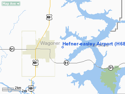
Location & QuickFacts
| FAA Information Effective: | 2008-09-25 |
| Airport Identifier: | H68 |
| Airport Status: | Operational |
| Longitude/Latitude: | 095-20-30.8760W/35-57-45.3580N
-95.341910/35.962599 (Estimated) |
| Elevation: | 609 ft / 185.62 m (Surveyed) |
| Land: | 68 acres |
| From nearest city: | 2 nautical miles E of Wagoner, OK |
| Location: | Wagoner County, OK |
| Magnetic Variation: | 06E (1985) |
Owner & Manager
| Ownership: | Publicly owned |
| Owner: | City Of Wagoner |
| Address: | Po Box 406, 231 Church St.
Wagoner, OK 74467 |
| Phone number: | 918-485-2554 |
| Manager: | Larry Morgan
CITY MANAGER. |
| Address: | Po Box 406, 231 Church St.
Wagoner, OK 74467 |
| Phone number: | 918-485-2554 |
Airport Operations and Facilities
| Airport Use: | Open to public |
| Wind indicator: | Yes |
| Segmented Circle: | Yes |
| Control Tower: | No |
| Lighting Schedule: | DUSK-DAWN |
| Beacon Color: | Clear-Green (lighted land airport) |
| Landing fee charge: | No |
| Sectional chart: | Dallas-ft Worth |
| Region: | ASW - Southwest |
| Boundary ARTCC: | ZME - Memphis |
| Responsible ARTCC: | ZKC - Kansas City |
| Tie-in FSS: | MLC - Mc Alester |
| FSS on Airport: | No |
| FSS Toll Free: | 1-800-WX-BRIEF |
| NOTAMs Facility: | MLC (NOTAM-d service avaliable) |
| Federal Agreements: | N |
Airport Communications
Airport Services
| Airframe Repair: | MAJOR |
| Power Plant Repair: | MAJOR |
| Bottled Oxygen: | NONE |
| Bulk Oxygen: | NONE |
Runway Information
Runway 18/36
| Dimension: | 3405 x 60 ft / 1037.8 x 18.3 m |
| Surface: | ASPH, Good Condition |
| Pavement Class: | 3 /F/C/Y/U |
| Weight Limit: | Single wheel: 12500 lbs. |
| Edge Lights: | Medium |
| |
Runway 18 |
Runway 36 |
| Longitude: | 095-20-30.6100W | 095-20-30.3400W |
| Latitude: | 35-58-13.3100N | 35-57-39.6900N |
| Elevation: | 584.00 ft | 598.00 ft |
| Alignment: | 127 | 127 |
| Traffic Pattern: | Left | Left |
| Markings: | Non-precision instrument, Fair Condition | Non-precision instrument, Fair Condition |
| Crossing Height: | 31.00 ft | 31.00 ft |
| VASI: | 2-light PAPI on left side
PAPI UNUSABLE BYD 7 DEGS LEFT OF CRS & 8 DEGS RIGHT OF CRS. | 2-light PAPI on left side
PAPI OTS INDEFLY. |
| Visual Glide Angle: | 3.00° | 3.00° |
| Obstruction: | 20 ft trees, 558.0 ft from runway, 17:1 slope to clear | 40 ft trees, 774.0 ft from runway, 14:1 slope to clear
-3 FT DITCH END OF RY 40 FT RIGHT OF CNTRLN. |
|
Runway N/S
| Dimension: | 1900 x 50 ft / 579.1 x 15.2 m |
| Surface: | TURF, Fair Condition |
| |
Runway N |
Runway S |
| Traffic Pattern: | Left | Left |
| Obstruction: | 40 ft trees, 1025.0 ft from runway, 25:1 slope to clear | , 50:1 slope to clear |
|
Radio Navigation Aids
| ID |
Type |
Name |
Ch |
Freq |
Var |
Dist |
| TQH | NDB | Tahlequah | | 215.00 | 05E | 16.5 nm |
| MKO | NDB | Muskogee | | 306.00 | 06E | 22.3 nm |
| DW | NDB | Owaso | | 375.00 | 06E | 33.2 nm |
| OWP | NDB | William Pogue | | 362.00 | 06E | 41.4 nm |
| IQS | NDB | Sallisaw | | 520.00 | 05E | 43.2 nm |
| SLG | NDB | Siloam Springs | | 284.00 | 04E | 43.6 nm |
| HET | NDB | Henryetta | | 267.00 | 04E | 46.9 nm |
| MEE | VOR | Davis | | 108.60 | 06E | 18.0 nm |
| OKM | VOR/DME | Okmulgee | 096X | 114.90 | 08E | 30.2 nm |
| GNP | VOR/DME | Glenpool | 043X | 110.60 | 06E | 30.6 nm |
| TUL | VORTAC | Tulsa | 091X | 114.40 | 08E | 25.8 nm |
| TUL | VOT | Tulsa Intl | | 109.00 | | 25.8 nm |
Remarks
Images and information placed above are from
http://www.airport-data.com/airport/H68/
We thank them for the data!
| General Info
|
| Country |
United States
|
| State |
OKLAHOMA
|
| FAA ID |
H68
|
| Latitude |
35-57-45.358N
|
| Longitude |
095-20-30.876W
|
| Elevation |
609 feet
|
| Near City |
WAGONER
|
We don't guarantee the information is fresh and accurate. The data may
be wrong or outdated.
For more up-to-date information please refer to other sources.
|
|


