 |
|
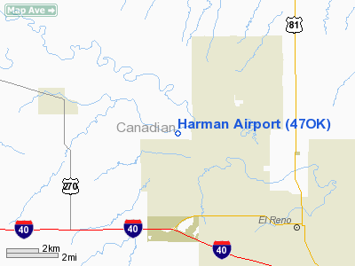
Location & QuickFacts
| FAA Information Effective: | 2008-09-25 |
| Airport Identifier: | 47OK |
| Airport Status: | Operational |
| Longitude/Latitude: | 098-02-24.1880W/35-35-01.1790N
-98.040052/35.583661 (Estimated) |
| Elevation: | 1345 ft / 409.96 m (Estimated) |
| Land: | 0 acres |
| From nearest city: | 4 nautical miles E of Calumet, OK |
| Location: | Canadian County, OK |
| Magnetic Variation: | 08E (1985) |
Owner & Manager
| Ownership: | Privately owned |
| Owner: | James F Harman Family Trust |
| Address: | 13025 W 122nd Nw
Calumet, OK 73014 |
| Phone number: | 405-893-2511 |
| Manager: | David Harman |
| Address: | 5600 N Brandley Rd
Calumet, OK 73014 |
| Phone number: | 405-262-8367 |
Airport Operations and Facilities
| Airport Use: | Private |
| Wind indicator: | Yes |
| Segmented Circle: | No |
| Control Tower: | No |
| Sectional chart: | Dallas-ft Worth |
| Region: | ASW - Southwest |
| Boundary ARTCC: | ZFW - Fort Worth |
| Tie-in FSS: | MLC - Mc Alester |
| FSS Toll Free: | 1-800-WX-BRIEF |
Runway Information
Runway 04/22
| Dimension: | 1950 x 50 ft / 594.4 x 15.2 m |
| Surface: | TURF, |
| |
Runway 04 |
Runway 22 |
| Traffic Pattern: | Left | Left |
|
Runway 08/26
| Dimension: | 2500 x 50 ft / 762.0 x 15.2 m |
| Surface: | TURF, |
| |
Runway 08 |
Runway 26 |
| Traffic Pattern: | Left | Left |
|
Runway 12/30
| Dimension: | 1700 x 50 ft / 518.2 x 15.2 m |
| Surface: | TURF, |
| |
Runway 12 |
Runway 30 |
| Traffic Pattern: | Left | Left |
|
Runway 17/35
| Dimension: | 1220 x 50 ft / 371.9 x 15.2 m |
| Surface: | TURF, |
| |
Runway 17 |
Runway 35 |
| Traffic Pattern: | Left | Left |
|
Radio Navigation Aids
| ID |
Type |
Name |
Ch |
Freq |
Var |
Dist |
| RQO | NDB | El Reno | | 335.00 | 07E | 6.5 nm |
| OK | NDB | Tuloo | | 406.00 | 07E | 22.3 nm |
| JWG | NDB | Watonga | | 359.00 | 07E | 25.2 nm |
| OLR | NDB | Chickasha | | 290.00 | 07E | 29.0 nm |
| OJA | NDB | Weatherford | | 272.00 | 07E | 31.0 nm |
| LCY | NDB | Logan County | | 326.00 | 07E | 34.3 nm |
| OUN | NDB | Norman | | 260.00 | 07E | 34.4 nm |
| CLK | NDB | Clinton | | 320.00 | 07E | 43.8 nm |
| FAU | NDB | Fairview | | 246.00 | 07E | 47.2 nm |
| TIK | TACAN | Tinker | 105X | | 07E | 33.5 nm |
| PWA | VOR/DME | Wiley Post | 081X | 113.40 | 08E | 19.5 nm |
| ODG | VOR/DME | Woodring | 027X | 109.00 | 08E | 49.0 nm |
| IFI | VORTAC | Kingfisher | 094X | 114.70 | 09E | 13.4 nm |
| IRW | VORTAC | Will Rogers | 088X | 114.10 | 07E | 25.1 nm |
| END | VORTAC | Vance | 101X | 115.40 | 09E | 46.2 nm |
| OKC | VOT | Oklahoma Will Rgs W | | 108.80 | | 24.4 nm |
Remarks
- PROVIDED ALL OPERATIONS ARE CONDUCTED EAST OR NORTH OF THE RNWYS.
Images and information placed above are from
http://www.airport-data.com/airport/47OK/
We thank them for the data!
| General Info
|
| Country |
United States
|
| State |
OKLAHOMA
|
| FAA ID |
47OK
|
| Latitude |
35-35-01.179N
|
| Longitude |
098-02-24.188W
|
| Elevation |
1345 feet
|
| Near City |
CALUMET
|
We don't guarantee the information is fresh and accurate. The data may
be wrong or outdated.
For more up-to-date information please refer to other sources.
|
|


