 |
|
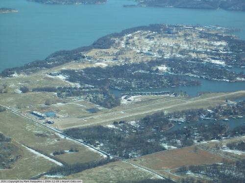 |
(Click on the photo to enlarge) |
Location & QuickFacts
| FAA Information Effective: | 2008-09-25 |
| Airport Identifier: | 3O9 |
| Airport Status: | Operational |
| Longitude/Latitude: | 094-51-42.8410W/36-34-39.2790N
-94.861900/36.577578 (Estimated) |
| Elevation: | 792 ft / 241.40 m (Surveyed) |
| Land: | 60 acres |
| From nearest city: | 9 nautical miles SE of Afton, OK |
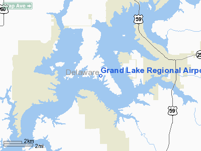
| Location: | Delaware County, OK |
| Magnetic Variation: | 05E (1985) |
Owner & Manager
| Ownership: | Privately owned |
| Owner: | Paul Staten |
| Address: | 56351 E. Hwy 125
Monkey Island, OK 74331 |
| Phone number: | 918-257-8602 |
| Manager: | Paul Staten |
| Address: | 56351 E. Hwy 125
Monkey Island, OK 74331 |
| Phone number: | 918-257-8602 |
Airport Operations and Facilities
| Airport Use: | Open to public |
| Wind indicator: | Yes |
| Segmented Circle: | No |
| Control Tower: | No |
| Lighting Schedule: | RDO-CTL
ACTVT MIRL RY 17/35; REIL RY 17; VASI RYS 17 & 35 - CTAF. |
| Landing fee charge: | No |
| Sectional chart: | Kansas City |
| Region: | ASW - Southwest |
| Boundary ARTCC: | ZKC - Kansas City |
| Tie-in FSS: | MLC - Mc Alester |
| FSS on Airport: | No |
| FSS Toll Free: | 1-800-WX-BRIEF |
| NOTAMs Facility: | MLC (NOTAM-d service avaliable) |
Airport Communications
| CTAF: | 122.700 |
| Unicom: | 122.700 |
Airport Services
Runway Information
Runway 17/35
| Dimension: | 3925 x 60 ft / 1196.3 x 18.3 m |
| Surface: | CONC, Good Condition |
| Weight Limit: | Single wheel: 30000 lbs.
Dual wheel: 60000 lbs.
Dual tandem wheel: 80000 lbs. |
| Edge Lights: | Medium |
| |
Runway 17 |
Runway 35 |
| Alignment: | 127 | 127 |
| Traffic Pattern: | Left | Left |
| Markings: | Non-precision instrument, Fair Condition | Non-precision instrument, Fair Condition |
| Crossing Height: | 35.00 ft | 29.00 ft |
| Displaced threshold: | 230.00 ft | 230.00 ft |
| VASI: | 2-box on left side | 2-box on left side
VASI OTS INDEFLY. |
| Visual Glide Angle: | 4.25° | 3.75° |
| Runway End Identifier: | Yes
REIL OTS INDEFLY. | |
| Obstruction: | 60 ft trees, 834.0 ft from runway, 10:1 slope to clear
APCH SLOPE 17:1 FM DSPLCD THLD.
+40 FT TREES 66 FT R AT THLD; 7 FT ROAD 40 FT ON CNTRLN. | , 50:1 slope to clear
APCH SLOPE 50:1 TO DSPLCD THLD. |
|
Radio Navigation Aids
| ID |
Type |
Name |
Ch |
Freq |
Var |
Dist |
| SLG | NDB | Siloam Springs | | 284.00 | 04E | 29.5 nm |
| TQH | NDB | Tahlequah | | 215.00 | 05E | 39.8 nm |
| CFV | NDB | Coffeyville | | 212.00 | 05E | 46.1 nm |
| EOS | VOR/DME | Neosho | 120X | 117.30 | 07E | 26.0 nm |
| DAK | VOR/DME | Drake | 025X | 108.80 | 07E | 45.5 nm |
| OSW | VORTAC | Oswego | 123X | 117.60 | 08E | 38.5 nm |
| RZC | VORTAC | Razorback | 111X | 116.40 | 04E | 41.0 nm |
Remarks
- +130 FT TOWER 1200 FT EAST OF RY 17.
- RY 17 END IS 30 FT HIGHER THAN RY 35 END.
- BIRDS ON & INVOF ARPT.
Images and information placed above are from
http://www.airport-data.com/airport/3O9/
We thank them for the data!
| General Info
|
| Country |
United States
|
| State |
OKLAHOMA
|
| FAA ID |
3O9
|
| Latitude |
36-34-39.279N
|
| Longitude |
094-51-42.841W
|
| Elevation |
792 feet
|
| Near City |
AFTON
|
We don't guarantee the information is fresh and accurate. The data may
be wrong or outdated.
For more up-to-date information please refer to other sources.
|
|


