|
|
| Frederick Regional Airport |
 |
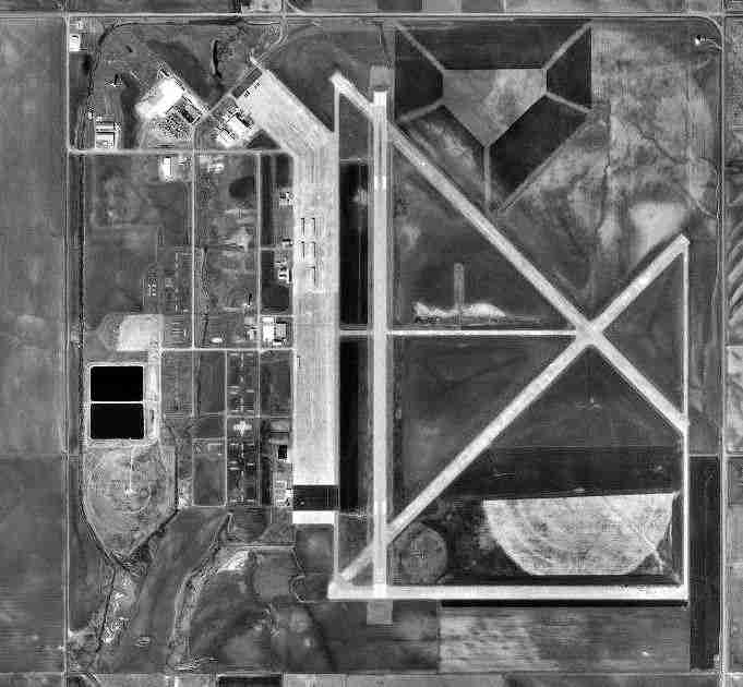
| USGS aerial image - 8 February 1995 |
| IATA: FDR – ICAO: KFDR – FAA LID: FDR |
| Summary |
| Airport type |
Public |
| Owner |
City of Frederick |
| Serves |
Frederick, Oklahoma |
| Elevation AMSL |
1,258 ft / 383 m |
| Coordinates |
34°21′08″N 098°59′02″W / 34.35222°N 98.98389°W / 34.35222; -98.98389 |
| Runways |
| Direction |
Length |
Surface |
| ft |
m |
| 3/21 |
4,812 |
1,467 |
Concrete |
| 12/30 |
4,578 |
1,395 |
Concrete |
| 17/35 |
6,099 |
1,859 |
Asphalt |
| 17L/35R |
3,180 |
969 |
Concrete |
| Statistics (2008) |
| Aircraft operations |
63,700 |
| Based aircraft |
17 |
| Source: Federal Aviation Administration |
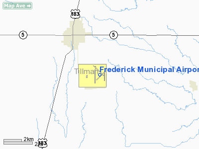
Frederick Regional Airport (IATA: FDR, ICAO: KFDR, FAA LID: FDR) is a city-owned, public-use airport located three nautical miles (6 km) southeast of the central business district of Frederick, a city in Tillman County, Oklahoma, United States. It was formerly known as Frederick Municipal Airport. History
Opened on 23 September 1942 as Frederick Army Airfield with four hard-surfaced runways, 3x6000' (00/18; 04/22; 13/31); 1x4380' (09/27). Also was used as civil airport in joint-use agreement. Assigned to United States Army Air Forces Gulf Coast Training Center (later Central Flying Training Command) as a advanced twin-engine (level 3) pilot training airfield. had four local auxiliary airfields for emergency and overflow landings. Inactivated on 31 October 1945 with the drawdown of AAFTC's pilot training program. Declared surplus and turned over to the Army Corps of Engineers on 21 September 1946. Eventually discharged to the War Assets Administration (WAA) and became a civil airport.
Facilities and aircraft
Frederick Regional Airport covers an area of 1,442 acres (584 ha) at an elevation of 1,258 feet (383 m) above mean sea level. It has four runways: 17/35 is 6,099 by 150 feet (1,859 x 46 m) with an asphalt surface; 3/21 is 4,812 by 60 feet (1,467 x 18 m) with a concrete surface; 12/30 is 4,578 by 75 feet (1,395 x 23 m) with a concrete surface; 17L/35R is 3,180 by 50 feet (969 x 15 m) with a concrete surface.
For the 12-month period ending June 9, 2008, the airport had 63,700 aircraft operations, an average of 174 per day: 94% military and 6% general aviation. At that time there were 17 aircraft based at this airport: 76% single-engine, 18% multi-engine and 6% military.
The above content comes from Wikipedia and is published under free licenses – click here to read more.
Location & QuickFacts
| FAA Information Effective: | 2008-09-25 |
| Airport Identifier: | FDR |
| Airport Status: | Operational |
| Longitude/Latitude: | 098-59-02.0727W/34-21-07.5449N
-98.983909/34.352096 (Estimated) |
| Elevation: | 1258 ft / 383.44 m (Surveyed) |
| Land: | 1442 acres |
| From nearest city: | 3 nautical miles SE of Frederick, OK |
| Location: | Tillman County, OK |
| Magnetic Variation: | 07E (2000) |
Owner & Manager
| Ownership: | Publicly owned |
| Owner: | City Of Frederick |
| Address: | City Hall Po Box 399
Frederick, OK 73542 |
| Phone number: | 580-335-7551 |
| Manager: | Donnie Coleman |
| Address: | City Hall Po Box 399
Frederick, OK 73542 |
| Phone number: | 580-335-2421 |
Airport Operations and Facilities
| Airport Use: | Open to public |
| Wind indicator: | Yes |
| Segmented Circle: | Yes |
| Control Tower: | No |
| Lighting Schedule: | DUSK-DAWN
ACTVT MIRL RY 17/35 - CTAF. |
| Beacon Color: | Clear-Green (lighted land airport) |
| Landing fee charge: | No |
| Sectional chart: | Dallas-ft Worth |
| Region: | ASW - Southwest |
| Boundary ARTCC: | ZFW - Fort Worth |
| Tie-in FSS: | MLC - Mc Alester |
| FSS on Airport: | No |
| FSS Toll Free: | 1-800-WX-BRIEF |
| NOTAMs Facility: | FDR (NOTAM-d service avaliable) |
| Federal Agreements: | NGPRY |
Airport Communications
| CTAF: | 123.050 |
| Unicom: | 123.050 |
Airport Services
| Fuel available: | 100LLA
FOR FUEL AFT HRS CALL 580-335-1948. |
| Bottled Oxygen: | NONE |
| Bulk Oxygen: | NONE |
Runway Information
Runway 03/21
| Dimension: | 4812 x 60 ft / 1466.7 x 18.3 m
MKD TO 60 FT WIDE; PAVEMENT 150 FT WIDE.
RY MKD TO 75 FT WIDE; PAVEMENT 150 FT WIDE. |
| Surface: | CONC, Poor Condition
MODERATE CRACKING AND DETERIORATION.
MODERATE CRACKING AND DETERIORATION. |
| Pavement Class: | 2 /R/C/Y/T |
| Weight Limit: | Single wheel: 30000 lbs. |
| |
Runway 03 |
Runway 21 |
| Longitude: | 098-59-18.3817W | 098-58-37.7712W |
| Latitude: | 34-20-46.9644N | 34-21-20.5946N |
| Elevation: | 1239.00 ft | 1253.00 ft |
| Alignment: | 45 | 127 |
| Traffic Pattern: | Left | Left |
| Markings: | Basic, Poor Condition
RY 03/21 MARKINGS FADED. | Basic, Poor Condition |
| Obstruction: | , 50:1 slope to clear | 15 ft road, 475.0 ft from runway, 18:1 slope to clear |
|
Runway 12/30
| Dimension: | 4578 x 75 ft / 1395.4 x 22.9 m
MKD TO 60 FT WIDE; PAVEMENT 150 FT WIDE.
RY MKD TO 75 FT WIDE; PAVEMENT 150 FT WIDE. |
| Surface: | CONC, Poor Condition
MODERATE CRACKING AND DETERIORATION.
MODERATE CRACKING AND DETERIORATION. |
| Pavement Class: | 2 /R/C/Y/T |
| Weight Limit: | Single wheel: 30000 lbs. |
| |
Runway 12 |
Runway 30 |
| Longitude: | 098-59-16.3717W | 098-58-37.7895W |
| Latitude: | 34-21-30.0278N | 34-20-57.9846N |
| Elevation: | 1256.00 ft | 1244.00 ft |
| Alignment: | 127 | 127 |
| Traffic Pattern: | Left | Left |
| Markings: | Basic, Poor Condition
MARKINGS SEVERELY FADED. | Basic, Poor Condition
MARKINGS SEVERELY FADED. |
| Obstruction: | , 50:1 slope to clear | 15 ft road, 475.0 ft from runway, 18:1 slope to clear |
|
Runway 17/35
| Dimension: | 6099 x 150 ft / 1859.0 x 45.7 m
MKD TO 60 FT WIDE; PAVEMENT 150 FT WIDE.
RY MKD TO 75 FT WIDE; PAVEMENT 150 FT WIDE. |
| Surface: | ASPH, Fair Condition
MODERATE CRACKING AND DETERIORATION.
MODERATE CRACKING AND DETERIORATION. |
| Pavement Class: | 3 /F/B/X/T |
| Weight Limit: | Single wheel: 35000 lbs.
Dual wheel: 50000 lbs.
Dual tandem wheel: 100000 lbs. |
| Edge Lights: | Medium |
| |
Runway 17 |
Runway 35 |
| Longitude: | 098-59-21.6106W | 098-59-21.6656W |
| Latitude: | 34-21-37.9970N | 34-20-37.6707N |
| Elevation: | 1254.00 ft | 1236.00 ft |
| Alignment: | 127 | 127 |
| Traffic Pattern: | Left | Left |
| Markings: | Non-precision instrument, Fair Condition | Non-precision instrument, Fair Condition |
| Crossing Height: | 40.00 ft | 40.00 ft |
| VASI: | 4-light PAPI on left side | 4-light PAPI on left side |
| Obstruction: | 15 ft road, 850.0 ft from runway, 43:1 slope to clear | , 50:1 slope to clear |
|
Runway 17L/35R
| Dimension: | 3180 x 50 ft / 969.3 x 15.2 m
MKD TO 60 FT WIDE; PAVEMENT 150 FT WIDE.
RY MKD TO 75 FT WIDE; PAVEMENT 150 FT WIDE. |
| Surface: | CONC, Fair Condition
MODERATE CRACKING AND DETERIORATION.
MODERATE CRACKING AND DETERIORATION. |
| |
Runway 17L |
Runway 35R |
| Longitude: | 098-58-37.7650W | 098-58-37.7980W |
| Latitude: | 34-21-19.1140N | 34-20-47.6600N |
| Elevation: | 1251.00 ft | 1233.00 ft |
| Alignment: | 127 | 127 |
| Traffic Pattern: | Left | Left |
| Markings: | Basic, Fair Condition
RY 17L/35R MARKINGS FADED. | Basic, Fair Condition |
| Obstruction: | 59 ft tower, 2364.0 ft from runway, 150 ft left of centerline, 36:1 slope to clear | , 50:1 slope to clear |
|
Radio Navigation Aids
| ID |
Type |
Name |
Ch |
Freq |
Var |
Dist |
| FSI | FAN MARKER | Trail | | | 09E | 38.7 nm |
| VRT | NDB | Wilbarger | | 230.00 | 08E | 16.5 nm |
| PFL | NDB | Post | | 308.00 | 08E | 32.6 nm |
| OFZ | NDB | Trail | | 388.00 | 09E | 38.7 nm |
| SKB | NDB | Scotland | | 344.00 | 08E | 41.9 nm |
| SHP | TACAN | Sheppard | 045X | | 10E | 33.2 nm |
| LAW | VOR/DME | Lawton | 031X | 109.40 | 09E | 29.6 nm |
| LTS | VORTAC | Altus | 035X | 109.80 | 08E | 23.5 nm |
| SPS | VORTAC | Wichita Falls | 074X | 112.70 | 10E | 29.3 nm |
| HBR | VORTAC | Hobart | 055X | 111.80 | 10E | 31.2 nm |
Remarks
- ARPT USED AS SHEPPARD AFB AUX. MIL TFC DALGT MON-FRI; CTC UNICOM FOR ADZY.
- MIL TFC ONLY WL USE RIGHT 360 DEG OVERHEAD APCHS TO RY 17.
- PRE DATES THE ACT.
Images and information placed above are from
http://www.airport-data.com/airport/FDR/
We thank them for the data!
| General Info
|
| Country |
United States
|
| State |
OKLAHOMA
|
| FAA ID |
FDR
|
| Latitude |
34-21-09.340N
|
| Longitude |
098-59-03.250W
|
| Elevation |
1255 feet
|
| Near City |
FREDERICK
|
We don't guarantee the information is fresh and accurate. The data may
be wrong or outdated.
For more up-to-date information please refer to other sources.
|
|