 |
|
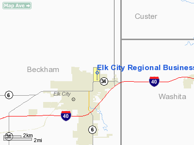
Elk City Rgnl Business Airport |
Location & QuickFacts
| FAA Information Effective: | 2008-09-25 |
| Airport Identifier: | ELK |
| Airport Status: | Operational |
| Longitude/Latitude: | 099-23-39.4000W/35-25-50.8000N
-99.394278/35.430778 (Estimated) |
| Elevation: | 2013 ft / 613.56 m (Surveyed) |
| Land: | 364 acres |
| From nearest city: | 1 nautical miles NE of Elk City, OK |
| Location: | Beckham County, OK |
| Magnetic Variation: | 06E (2010) |
Owner & Manager
| Ownership: | Publicly owned |
| Owner: | City Of Elk City |
| Address: | Box 1100
Elk City, OK 73644 |
| Phone number: | 580-225-3230 |
| Manager: | Don Creed |
| Address: | Box 1100, 101 Norman Martin Blvd.
Elk City, OK 73648 |
| Phone number: | 580-225-7700 |
Airport Operations and Facilities
| Airport Use: | Open to public |
| Wind indicator: | Yes |
| Segmented Circle: | Yes |
| Control Tower: | No |
| Lighting Schedule: | DUSK-DAWN
ACTVT MIRL RY 17/35 & REIL RY 17 - CTAF. PAPI RYS 17 & 35 OPER CONTINUOUSLY. |
| Beacon Color: | Clear-Green (lighted land airport)
ROTG BCN OTS INDEFLY. |
| Landing fee charge: | No |
| Sectional chart: | Dallas-ft Worth |
| Region: | ASW - Southwest |
| Traffic Pattern Alt: | 1000 ft |
| Boundary ARTCC: | ZFW - Fort Worth |
| Tie-in FSS: | MLC - Mc Alester |
| FSS on Airport: | No |
| FSS Toll Free: | 1-800-WX-BRIEF |
| NOTAMs Facility: | MLC (NOTAM-d service avaliable) |
| Federal Agreements: | NGY |
Airport Communications
| CTAF: | 122.800 |
| Unicom: | 122.800 |
Airport Services
| Fuel available: | 100LLA |
| Airframe Repair: | MAJOR |
| Power Plant Repair: | MAJOR |
| Bottled Oxygen: | NONE |
| Bulk Oxygen: | NONE |
Runway Information
Runway 17/35
| Dimension: | 5399 x 75 ft / 1645.6 x 22.9 m |
| Surface: | CONC, Good Condition |
| Pavement Class: | 4 /R/B/X/T |
| Weight Limit: | Single wheel: 30000 lbs. |
| Edge Lights: | Medium |
| |
Runway 17 |
Runway 35 |
| Longitude: | 099-23-39.3234W | 099-23-39.4714W |
| Latitude: | 35-26-17.5462N | 35-25-24.1475N |
| Elevation: | 2013.00 ft | 1974.00 ft |
| Alignment: | 127 | 0 |
| Traffic Pattern: | Left | Left |
| Markings: | Non-precision instrument, Good Condition | Non-precision instrument, Good Condition |
| Crossing Height: | 19.00 ft | 19.00 ft |
| VASI: | 2-light PAPI on left side | 2-light PAPI on left side |
| Visual Glide Angle: | 3.00° | 3.50° |
| Runway End Identifier: | Yes | |
| Obstruction: | , 50:1 slope to clear | 30 ft pole, 990.0 ft from runway, 277 ft left of centerline, 26:1 slope to clear |
|
Radio Navigation Aids
| ID |
Type |
Name |
Ch |
Freq |
Var |
Dist |
| EZY | NDB | Elk City | | 241.00 | 08E | 0.3 nm |
| BZ | NDB | Fossi | | 393.00 | 08E | 9.5 nm |
| CLK | NDB | Clinton | | 320.00 | 07E | 23.4 nm |
| OJA | NDB | Weatherford | | 272.00 | 07E | 35.9 nm |
| SYO | VORTAC | Sayre | 099X | 115.20 | 10E | 12.9 nm |
| BFV | VORTAC | Burns Flat | 037X | 110.00 | 08E | 14.9 nm |
| HBR | VORTAC | Hobart | 055X | 111.80 | 10E | 37.6 nm |
| LTS | VORTAC | Altus | 035X | 109.80 | 08E | 46.6 nm |
Remarks
- DITCH LCTD OFF THE NW SIDE OF PARALLEL TWY.
- ULTRALIGHT ACTIVITY ON AND IN VICINITY OF AIRPORT.
Images and information placed above are from
http://www.airport-data.com/airport/ELK/
We thank them for the data!
| General Info
|
| Country |
United States
|
| State |
OKLAHOMA
|
| FAA ID |
ELK
|
| Latitude |
35-25-45.879N
|
| Longitude |
099-23-39.333W
|
| Elevation |
2002 feet
|
| Near City |
ELK CITY
|
We don't guarantee the information is fresh and accurate. The data may
be wrong or outdated.
For more up-to-date information please refer to other sources.
|
|


