 |
|
| Earl Henry Airport |
| IATA: BWL – ICAO: none – FAA LID: 6OK6 |
| Summary |
| Airport type |
Private |
| Owner |
Earl Henry Flying Service |
| Serves |
Blackwell, Oklahoma |
| Elevation AMSL |
1,054 ft / 321 m |
| Coordinates |
36°47′45″N 097°19′01″W / 36.79583°N 97.31694°W / 36.79583; -97.31694 |
| Runways |
| Direction |
Length |
Surface |
| ft |
m |
| 17/35 |
2,400 |
732 |
Turf/Gravel |
| Statistics |
| Aircraft operations |
370 |
| Source: Federal Aviation Administration |
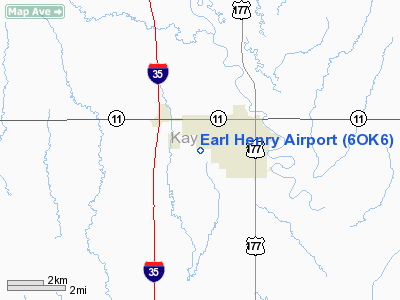
Earl Henry Airport (IATA: BWL, FAA LID: 6OK6) is a private-use airport located two nautical miles (4 km) west of the central business district of Blackwell, in Kay County, Oklahoma, United States.
Facilities and aircraft
Earl Henry Airport covers an area of 160 acres (65 ha) at an elevation of 1,054 feet (321 m) above mean sea level. It has one runway designated 17/35 with a 2,400 by 120 ft (732 x 37 m) turf and gravel surface. For the most recent 12-month period reported, the airport had 370 aircraft operations, an average of 30 per month: 68% general aviation and 32% military.
The above content comes from Wikipedia and is published under free licenses – click here to read more.
Location & QuickFacts
| FAA Information Effective: | 2008-09-25 |
| Airport Identifier: | 6OK6 |
| Airport Status: | Operational |
| Longitude/Latitude: | 097-19-01.1570W/36-47-45.1150N
-97.316988/36.795865 (Estimated) |
| Elevation: | 1054 ft / 321.26 m (Estimated) |
| Land: | 160 acres |
| From nearest city: | 2 nautical miles W of Blackwell, OK |
| Location: | Kay County, OK |
| Magnetic Variation: | 07E (1985) |
Owner & Manager
| Ownership: | Privately owned |
| Owner: | Earl Henry Flying Service |
| Address: | P.o. Box 274
Burneyville, OK 73430 |
| Phone number: | 405-276-5081 |
| Manager: | John W. Henry |
| Address: | P.o. Box 274
Burneyville, OK 73430 |
| Phone number: | 405-276-5081 |
Airport Operations and Facilities
| Airport Use: | Private |
| Wind indicator: | Yes |
| Segmented Circle: | Yes |
| Control Tower: | No |
| Landing fee charge: | No |
| Sectional chart: | Wichita |
| Region: | ASW - Southwest |
| Boundary ARTCC: | ZKC - Kansas City |
| Tie-in FSS: | MLC - Mc Alester |
| FSS on Airport: | No |
| FSS Toll Free: | 1-800-WX-BRIEF |
Airport Services
| Airframe Repair: | NONE |
| Power Plant Repair: | NONE |
| Bottled Oxygen: | NONE |
| Bulk Oxygen: | NONE |
Runway Information
Runway 17/35
| Dimension: | 2400 x 120 ft / 731.5 x 36.6 m |
| Surface: | TURF-GRVL, |
| |
Runway 17 |
Runway 35 |
| Traffic Pattern: | Left | Left |
| Runway End Identifier: | No | No |
| Centerline Lights: | No | No |
| Touchdown Lights: | No | No |
|
Radio Navigation Aids
| ID |
Type |
Name |
Ch |
Freq |
Var |
Dist |
| PN | NDB | Ponca | | 515.00 | 05E | 10.6 nm |
| EGT | NDB | Wellington | | 414.00 | 07E | 31.9 nm |
| IC | NDB | Piche | | 332.00 | 07E | 47.5 nm |
| IAB | TACAN | Mc Connell | 112X | | 07E | 49.7 nm |
| ODG | VOR/DME | Woodring | 027X | 109.00 | 08E | 34.1 nm |
| SWO | VOR/DME | Stillwater | 021X | 108.40 | 07E | 36.2 nm |
| PER | VORTAC | Pioneer | 079X | 113.20 | 06E | 8.1 nm |
| END | VORTAC | Vance | 101X | 115.40 | 09E | 39.7 nm |
| ANY | VORTAC | Anthony | 076X | 112.90 | 07E | 46.4 nm |
Remarks
Images and information placed above are from
http://www.airport-data.com/airport/6OK6/
We thank them for the data!
| General Info
|
| Country |
United States
|
| State |
OKLAHOMA
|
| FAA ID |
6OK6
|
| Latitude |
36-47-45.115N
|
| Longitude |
097-19-01.157W
|
| Elevation |
1054 feet
|
| Near City |
BLACKWELL
|
We don't guarantee the information is fresh and accurate. The data may
be wrong or outdated.
For more up-to-date information please refer to other sources.
|
|


