|
|
| Eaker Field |
 |
| IATA: DUA – ICAO: KDUA – FAA LID: DUA |
| Summary |
| Airport type |
Public |
| Owner |
City of Durant |
| Serves |
Durant |
| Elevation AMSL |
699 ft / 213 m |
| Coordinates |
33°56′32″N 096°23′40″W / 33.94222°N 96.39444°W / 33.94222; -96.39444 |
| Website |
aviation.se.edu/... |
| Runways |
| Direction |
Length |
Surface |
| ft |
m |
| 17/35 |
5,001 |
1,524 |
Asphalt |
| 12/30 |
3,000 |
914 |
Asphalt |
| Statistics (2005) |
| Aircraft operations |
46,355 |
| Based aircraft |
21 |
| Source: Federal Aviation Administration |
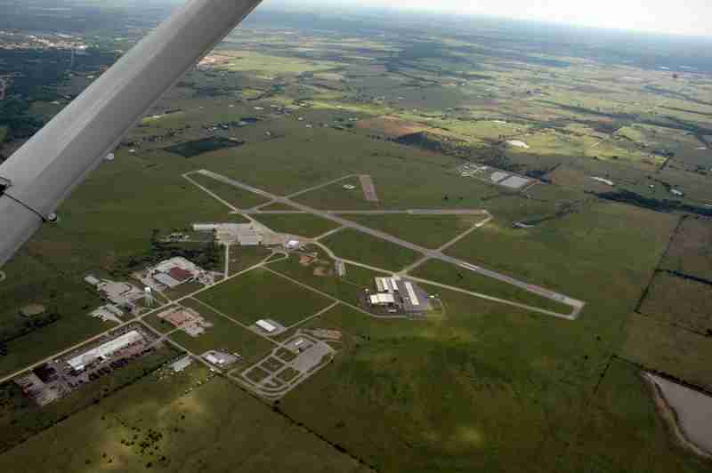
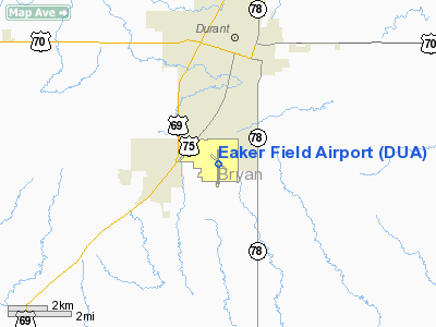
Eaker Field (IATA: DUA, ICAO: KDUA, FAA LID: DUA) is a public airport located three miles south of the City of Durant, Oklahoma, established in September 1943. It is three miles south of Durant's central business district, off of U.S. 69/75. Its field elevation is 698 feet. The airport is home to Southeastern Oklahoma State University's Aviation Sciences Institute. History
The airport is named in honor of SOSU alum General Ira Eaker. General Eaker was a 1917 graduate of Southeastern and served in both World War I and World War II. During WWII, General Eaker was commander of the Eighth Air Force in England and led several historic bombing missions against Nazi targets in occupied Europe and Germany.
The City of Durant named an airfield west of the town in honor of then Captain Eaker in the 1930s. The U.S. Navy built the current airfield as an auxiliary field during WWII and it became Durant Municipal Airport after the war. It was later renamed Eaker Field.
Facilities and aircraft
Eaker Field covers an area of 840 acres and contains two runways designated 12/30 and 17/35. Runway 12/30 is 3,000 x 75 ft (914.4 x 22.9 m) and runway 17/35 is 5,001 x 100 ft (1,524.3 x 30.5 m), both with asphalt pavement.
For a 12-month period ending August 25, 2005, the airport had 46,355 aircraft operations, an average of 127 per day: 97.8% general aviation, 2.2% general aviation itinerant, 0.1% military. At that time there were 21 aircraft based at this airport: 17 single-engine, 3 multi-engine, and 1 jet.
Expansion
The Durant Industrial Authority is currently in the process of putting the new airport terminal building design for Eaker Field up for bid. According to city officials, the need for a terminal building is drived by the growing economy in Durant and surrounding areas. The terminal building will be approximately 8,000 ft.
The terminal design initially called for an air traffic control tower, but was later dropped due to the cost.
A new taxiway is also in the early bidding process for Eaker Field. The taxiway project will be done in two phases along runway 17/35. Phase 1 will cover about half of the distance, around 2,500 feet, and is set to be completed in 2010. Phase II will include the remaining footage of the runway.
The above content comes from Wikipedia and is published under free licenses – click here to read more.
Location & QuickFacts
| FAA Information Effective: | 2008-09-25 |
| Airport Identifier: | DUA |
| Airport Status: | Operational |
| Longitude/Latitude: | 096-23-40.2650W/33-56-32.1540N
-96.394518/33.942265 (Estimated) |
| Elevation: | 698 ft / 212.75 m (Surveyed) |
| Land: | 840 acres |
| From nearest city: | 3 nautical miles SW of Durant, OK |
| Location: | Bryan County, OK |
| Magnetic Variation: | 05E (2000) |
Owner & Manager
| Ownership: | Publicly owned |
| Owner: | City Of Durant |
| Address: | 201 N 3rd Muni Bldg
Durant, OK 74701 |
| Phone number: | 580-924-7222 |
| Manager: | Dewayne Williams |
| Address: | 10 Waldron Dr
Durant, OK 74701 |
| Phone number: | 580-920-0574 |
Airport Operations and Facilities
| Airport Use: | Open to public |
| Wind indicator: | Yes |
| Segmented Circle: | Yes |
| Control Tower: | No |
| Lighting Schedule: | DUSK-DAWN
ACTVT MIRL RY 17/35 - CTAF. |
| Beacon Color: | Clear-Green (lighted land airport) |
| Landing fee charge: | No |
| Sectional chart: | Dallas-ft Worth |
| Region: | ASW - Southwest |
| Boundary ARTCC: | ZFW - Fort Worth |
| Tie-in FSS: | MLC - Mc Alester |
| FSS on Airport: | No |
| FSS Toll Free: | 1-800-WX-BRIEF |
| NOTAMs Facility: | DUA (NOTAM-d service avaliable) |
| Federal Agreements: | NGRY3 |
Airport Communications
| CTAF: | 122.800 |
| Unicom: | 122.800 |
Airport Services
| Fuel available: | 100LLA
FOR FUEL AFT HRS CALL 580-230-1188. |
| Airframe Repair: | MAJOR |
| Power Plant Repair: | MAJOR |
| Bulk Oxygen: | NONE |
Runway Information
Runway 12/30
| Dimension: | 3000 x 75 ft / 914.4 x 22.9 m |
| Surface: | ASPH, Fair Condition |
| Weight Limit: | Single wheel: 35000 lbs.
Dual wheel: 50000 lbs. |
| |
Runway 12 |
Runway 30 |
| Longitude: | 096-23-50.2940W | 096-23-24.1900W |
| Latitude: | 33-56-42.8270N | 33-56-22.6450N |
| Elevation: | 690.00 ft | 674.00 ft |
| Alignment: | 127 | 127 |
| Traffic Pattern: | Left | Left |
| Markings: | Basic, Fair Condition | Basic, Fair Condition |
| Obstruction: | , 50:1 slope to clear | 15 ft tree, 450.0 ft from runway, 75 ft left of centerline, 16:1 slope to clear |
|
Runway 17/35
| Dimension: | 5001 x 100 ft / 1524.3 x 30.5 m |
| Surface: | ASPH, Good Condition |
| Weight Limit: | Single wheel: 35000 lbs.
Dual wheel: 50000 lbs. |
| Edge Lights: | Non-standard lighting system
NSTD MIRL. MIRL LCTD 37 FT FM RY EDGES. |
| |
Runway 17 |
Runway 35 |
| Longitude: | 096-23-41.9670W | 096-23-42.3220W |
| Latitude: | 33-56-56.5580N | 33-56-07.0860N |
| Elevation: | 698.00 ft | 689.00 ft |
| Alignment: | 127 | 0 |
| Traffic Pattern: | Left | Left |
| Markings: | Non-precision instrument, Good Condition | Non-precision instrument, Good Condition |
| Crossing Height: | 49.00 ft | 48.00 ft |
| VASI: | 4-light PAPI on left side | 4-light PAPI on left side |
| Visual Glide Angle: | 3.00° | 3.00° |
| Runway End Identifier: | Yes
REIL OTS INDEFLY. | Yes |
| Obstruction: | , 50:1 slope to clear | 4 ft fence, 375.0 ft from runway, 43:1 slope to clear |
|
Radio Navigation Aids
| ID |
Type |
Name |
Ch |
Freq |
Var |
Dist |
| DUA | NDB | Durant | | 359.00 | 05E | 0.3 nm |
| DNI | NDB | Denison | | 341.00 | 06E | 15.5 nm |
| HJM | NDB | Rayburn | | 415.00 | 06E | 22.5 nm |
| AUV | NDB | Arbuckle | | 284.00 | 07E | 38.5 nm |
| AEE | NDB | Antlers | | 391.00 | 05E | 39.9 nm |
| GLE | NDB | Gainesville | | 330.00 | 06E | 42.3 nm |
| HHW | NDB | Hugo | | 323.00 | 05E | 43.0 nm |
| URH | VOR/DME | Texoma | 090X | 114.30 | 05E | 0.2 nm |
| BYP | VORTAC | Bonham | 093X | 114.60 | 06E | 25.6 nm |
| ADM | VORTAC | Ardmore | 114X | 116.70 | 06E | 41.8 nm |
Remarks
- LARGE FLOCKS OF BIRDS INVOF ARPT.
- 372 FT TOWER 2.5 MILES N OF ARPT.
- EXTENSIVE STUDENT TRNG INVOF ARPT & OVER LAKE TEXOMA.
- PAEW ADJ RY 17/35.
- PAEW ADJ TERMINAL BLDG.
- CENTER TWY CLSD INDEFLY.
- RAMP CLSD 200 FT SOUTH FM CENTER TWY INDEFLY.
- ARPT ESTAB PRIOR TO 1959.
Images and information placed above are from
http://www.airport-data.com/airport/DUA/
We thank them for the data!
| General Info
|
| Country |
United States
|
| State |
OKLAHOMA
|
| FAA ID |
DUA
|
| Latitude |
33-56-32.154N
|
| Longitude |
096-23-40.265W
|
| Elevation |
698 feet
|
| Near City |
DURANT
|
We don't guarantee the information is fresh and accurate. The data may
be wrong or outdated.
For more up-to-date information please refer to other sources.
|
|