 |
|
| David Jay Perry Airport |
| IATA: none – ICAO: none – FAA LID: 1K4 |
| Summary |
| Airport type |
Public |
| Owner |
Town of Goldsby |
| Serves |
Goldsby, Oklahoma |
| Elevation AMSL |
1,168 ft / 356 m |
| Coordinates |
35°09′18.2430″N 097°28′13.4180″W / 35.1550675°N 97.47039389°W / 35.1550675; -97.47039389Coordinates: 35°09′18.2430″N 097°28′13.4180″W / 35.1550675°N 97.47039389°W / 35.1550675; -97.47039389 |
| Runways |
| Direction |
Length |
Surface |
| ft |
m |
| 13/31 |
3,006 |
916 |
Concrete |
| 17/35 |
1,803 |
550 |
Asphalt |
| Source: Federal Aviation Administration |
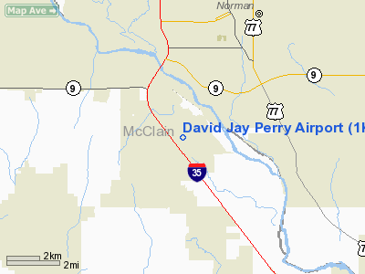
David Jay Perry Airport is a town-owned public-use airport in Goldsby, a town in McClain County, Oklahoma, United States. The airport is located near the interchange of I-35 and State Highway 74.
Facilities and aircraft
David Jay Perry Airport covers an area of 392 acres (159 ha) at an elevation of 1,113 feet (339 m) above mean sea level. It has two runways—one designated 17/35 with a 1,803×60 ft (550×18 m) asphalt surface, and one designated 13/31 with a 3,006×60 ft (916×18 m) concrete surface.
The above content comes from Wikipedia and is published under free licenses – click here to read more.
Location & QuickFacts
| FAA Information Effective: | 2008-09-25 |
| Airport Identifier: | 1K4 |
| Airport Status: | Operational |
| Longitude/Latitude: | 097-28-13.4180W/35-09-18.2430N
-97.470394/35.155068 (Estimated) |
| Elevation: | 1168 ft / 356.01 m (Surveyed) |
| Land: | 392 acres |
| From nearest city: | 1 nautical miles NE of Goldsby, OK |
| Location: | Mc Clain County, OK |
| Magnetic Variation: | 06E (1995) |
Owner & Manager
| Ownership: | Publicly owned |
| Owner: | Town Of Goldsby |
| Address: | 100 E. Center Road
Goldsby, OK 73093 |
| Phone number: | 405-288-6675 |
| Manager: | Virgie Andrews
CITY CLERK. |
| Address: | 100 E. Center Road
Goldsby, OK 73093 |
| Phone number: | 405-288-6675 |
Airport Operations and Facilities
| Airport Use: | Open to public |
| Wind indicator: | Yes |
| Segmented Circle: | Yes |
| Control Tower: | No |
| Lighting Schedule: | DUSK-DAWN |
| Beacon Color: | Clear-Green (lighted land airport) |
| Landing fee charge: | No |
| Sectional chart: | Dallas-ft Worth |
| Region: | ASW - Southwest |
| Boundary ARTCC: | ZFW - Fort Worth |
| Tie-in FSS: | MLC - Mc Alester |
| FSS on Airport: | No |
| FSS Toll Free: | 1-800-WX-BRIEF |
| NOTAMs Facility: | MLC (NOTAM-d service avaliable) |
| Federal Agreements: | NGRY |
Airport Communications
| CTAF: | 122.700 |
| Unicom: | 122.700 |
Airport Services
| Fuel available: | 100LL
24 HOUR AUTOMATED FUEL SERVICING SYSTEM. |
| Airframe Repair: | MINOR |
| Power Plant Repair: | MINOR |
| Bottled Oxygen: | NONE |
| Bulk Oxygen: | NONE |
Runway Information
Runway 13/31
| Dimension: | 3006 x 60 ft / 916.2 x 18.3 m |
| Surface: | CONC, Good Condition |
| Surface Treatment: | Saw-cut or plastic Grooved |
| Pavement Class: | 4 /R/C/Y/T |
| Weight Limit: | Single wheel: 30000 lbs. |
| Edge Lights: | Medium |
| |
Runway 13 |
Runway 31 |
| Longitude: | 097-28-25.2930W | 097-28-00.5790W |
| Latitude: | 35-09-27.9570N | 35-09-06.2310N |
| Elevation: | 1167.00 ft | 1156.00 ft |
| Alignment: | 127 | 127 |
| Traffic Pattern: | Left | Left |
| Markings: | Basic, Good Condition | Non-precision instrument, Good Condition |
| Obstruction: | 60 ft trees, 1304.0 ft from runway, 183L/ ft right of centerline, 18:1 slope to clear
+10 FT ACCESS ROAD 38 FT FM RY END. | 45 ft trees, 1020.0 ft from runway, 150L/ ft right of centerline, 18:1 slope to clear |
|
Runway 17/35
| Dimension: | 1803 x 60 ft / 549.6 x 18.3 m |
| Surface: | ASPH, Good Condition |
| Pavement Class: | 4 /F/C/Y/U |
| Weight Limit: | Single wheel: 4000 lbs. |
| |
Runway 17 |
Runway 35 |
| Longitude: | 097-28-14.0480W | 097-28-14.5730W |
| Latitude: | 35-09-29.0130N | 35-09-11.1860N |
| Elevation: | 1168.00 ft | 1161.00 ft |
| Alignment: | 127 | 1 |
| Traffic Pattern: | Left | Left |
| Markings: | Basic, Good Condition | Basic, Good Condition |
| Obstruction: | 35 ft trees, 600.0 ft from runway, 11:1 slope to clear
+10 FT ACCESS ROAD 50 FT FM RY END. | 50 ft trees, 900.0 ft from runway, 110 ft right of centerline, 14:1 slope to clear |
|
Radio Navigation Aids
| ID |
Type |
Name |
Ch |
Freq |
Var |
Dist |
| OUN | NDB | Norman | | 260.00 | 07E | 5.6 nm |
| OK | NDB | Tuloo | | 406.00 | 07E | 20.1 nm |
| OLR | NDB | Chickasha | | 290.00 | 07E | 24.8 nm |
| PVJ | NDB | Pauls Valley | | 384.00 | 06E | 29.0 nm |
| RQO | NDB | El Reno | | 335.00 | 07E | 32.8 nm |
| SRE | NDB | Seminole | | 278.00 | 06E | 39.7 nm |
| LCY | NDB | Logan County | | 326.00 | 07E | 41.6 nm |
| GGU | NDB | Prague | | 314.00 | 06E | 42.8 nm |
| CQB | NDB | Tilghman | | 396.00 | 06E | 46.7 nm |
| TIK | TACAN | Tinker | 105X | | 07E | 17.5 nm |
| PWA | VOR/DME | Wiley Post | 081X | 113.40 | 08E | 24.3 nm |
| ADH | VOR/DME | Ada | 125X | 117.80 | 06E | 44.7 nm |
| IRW | VORTAC | Will Rogers | 088X | 114.10 | 07E | 14.0 nm |
| IFI | VORTAC | Kingfisher | 094X | 114.70 | 09E | 47.0 nm |
| OKC | VOT | Oklahoma Will Rgs W | | 108.80 | | 15.7 nm |
Remarks
- INTENSIVE STUDENT TRNG DALGT HRS.
- ULTRALIGHT ACTIVITY ON & INVOF ARPT.
- COYOTES ON & INVOF RY.
Images and information placed above are from
http://www.airport-data.com/airport/1K4/
We thank them for the data!
| General Info
|
| Country |
United States
|
| State |
OKLAHOMA
|
| FAA ID |
1K4
|
| Latitude |
35-09-18.243N
|
| Longitude |
097-28-13.418W
|
| Elevation |
1168 feet
|
| Near City |
GOLDSBY
|
We don't guarantee the information is fresh and accurate. The data may
be wrong or outdated.
For more up-to-date information please refer to other sources.
|
|


