 |
|
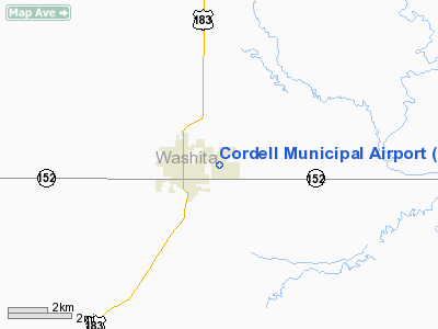
Location & QuickFacts
| FAA Information Effective: | 2008-09-25 |
| Airport Identifier: | F36 |
| Airport Status: | Operational |
| Longitude/Latitude: | 098-58-02.7800W/35-17-51.2400N
-98.967439/35.297567 (Estimated) |
| Elevation: | 1589 ft / 484.33 m (Surveyed) |
| Land: | 160 acres |
| From nearest city: | 1 nautical miles E of Cordell, OK |
| Location: | Washita County, OK |
| Magnetic Variation: | 08E (1985) |
Owner & Manager
| Ownership: | Publicly owned |
| Owner: | City Of Cordell |
| Address: | City Hall 101 E Main
Cordell, OK 73632 |
| Phone number: | 580-832-3825 |
| Manager: | Charlie Brown |
| Address: | City Hall 101 E Main
Cordell, OK 73632 |
| Phone number: | 580-660-0417 |
Airport Operations and Facilities
| Airport Use: | Open to public |
| Wind indicator: | Yes |
| Segmented Circle: | No |
| Control Tower: | No |
| Lighting Schedule: | DUSK-DAWN |
| Beacon Color: | Clear-Green (lighted land airport) |
| Landing fee charge: | No |
| Sectional chart: | Dallas-ft Worth |
| Region: | ASW - Southwest |
| Boundary ARTCC: | ZFW - Fort Worth |
| Tie-in FSS: | MLC - Mc Alester |
| FSS on Airport: | No |
| FSS Toll Free: | 1-800-WX-BRIEF |
| NOTAMs Facility: | MLC (NOTAM-d service avaliable) |
| Federal Agreements: | NGY |
Airport Communications
Airport Services
Runway Information
Runway 04/22
| Dimension: | 2000 x 100 ft / 609.6 x 30.5 m |
| Surface: | TURF, Fair Condition |
| |
Runway 04 |
Runway 22 |
| Traffic Pattern: | Left | Left |
| Obstruction: | 35 ft pline, 930.0 ft from runway, 26:1 slope to clear | 5 ft gnd, 200.0 ft from runway, 40:1 slope to clear |
|
Runway 17/35
| Dimension: | 3650 x 60 ft / 1112.5 x 18.3 m |
| Surface: | ASPH, Fair Condition |
| Weight Limit: | Single wheel: 12600 lbs. |
| Edge Lights: | Medium |
| |
Runway 17 |
Runway 35 |
| Traffic Pattern: | Left | Left |
| Markings: | Basic, Fair Condition | Basic, Fair Condition |
| VASI: | pulsating/steady burning on left side
PVASI OTS INDEFLY. | |
| Obstruction: | , 50:1 slope to clear | 15 ft road, 431.0 ft from runway, 15:1 slope to clear |
|
Radio Navigation Aids
| ID |
Type |
Name |
Ch |
Freq |
Var |
Dist |
| FSI | FAN MARKER | Trail | | | 09E | 41.7 nm |
| CLK | NDB | Clinton | | 320.00 | 07E | 14.6 nm |
| BZ | NDB | Fossi | | 393.00 | 08E | 14.7 nm |
| OJA | NDB | Weatherford | | 272.00 | 07E | 20.2 nm |
| EZY | NDB | Elk City | | 241.00 | 08E | 22.5 nm |
| OFZ | NDB | Trail | | 388.00 | 09E | 41.7 nm |
| JWG | NDB | Watonga | | 359.00 | 07E | 43.0 nm |
| RQO | NDB | El Reno | | 335.00 | 07E | 48.2 nm |
| PFL | NDB | Post | | 308.00 | 08E | 49.8 nm |
| BFV | VORTAC | Burns Flat | 037X | 110.00 | 08E | 12.3 nm |
| HBR | VORTAC | Hobart | 055X | 111.80 | 10E | 26.3 nm |
| SYO | VORTAC | Sayre | 099X | 115.20 | 10E | 32.9 nm |
| LTS | VORTAC | Altus | 035X | 109.80 | 08E | 41.0 nm |
Remarks
- ULTRALIGHTS ON AND IN VICINITY OF AIRPORT.
Images and information placed above are from
http://www.airport-data.com/airport/F36/
We thank them for the data!
| General Info
|
| Country |
United States
|
| State |
OKLAHOMA
|
| FAA ID |
F36
|
| Latitude |
35-17-51.240N
|
| Longitude |
098-58-02.780W
|
| Elevation |
1589 feet
|
| Near City |
CORDELL
|
We don't guarantee the information is fresh and accurate. The data may
be wrong or outdated.
For more up-to-date information please refer to other sources.
|
|


