|
|
Coordinates: 35°20′23″N 099°12′02″W / 35.33972°N 99.20056°W / 35.33972; -99.20056
| Clinton-Sherman Industrial Airpark |
 |
 |
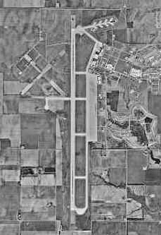
| Airfield diagram from Federal Aviation Administration |
| IATA: CSM – ICAO: KCSM – FAA LID: CSM |
| Summary |
| Airport type |
Public |
| Owner |
City of Clinton |
| Serves |
Clinton, Oklahoma |
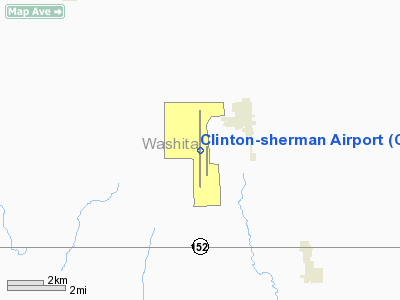
| Location |
Burns Flat, Oklahoma |
| Elevation AMSL |
1,922 ft / 586 m |
| Runways |
| Direction |
Length |
Surface |
| ft |
m |
| 17R/35L |
13,503 |
4,116 |
Concrete |
| 17L/35R |
5,193 |
1,583 |
Concrete |
| Statistics (2006) |
| Aircraft operations |
49,500 |
| Source: Federal Aviation Administration |
- For the military use of the facility before 1969 see Clinton-Sherman Air Force Base
The Clinton-Sherman Industrial Airpark, also known as the Oklahoma Spaceport is a newly authorized spaceport near Burns Flat, Oklahoma, in the western part of the state. The Federal Aviation Administration (FAA) granted a license to the site in June 2006 to the Oklahoma Space Industry Development Authority (OSIDA) to "oversee the takeoff and landing of suborbital, reusable launch vehicles". The license expires in five years and requires regular safety inspections by the FAA. Individual operators must also secure a separate license in order to make space flights from the facility.
|
Contents
- 1 Facilities
- 2 History
- 3 Licensing
- 4 Operations
- 5 References
- 6 External links
|
[edit] Facilities
The airpark is at the site of a public airfield known as Clinton-Sherman Airport (IATA: CSM, ICAO: KCSM). The airport covers an area of 1,690 acres (684 ha) which contains two concrete paved runways: 17R/35L measuring 13,503 x 150 ft. and 17L/35R measuring 5,193 x 75 ft. (1,583 x 23 m). The longer of these, at 13,503 x 150 ft (4,116 x 46 m) is a major benefit for use as a spaceport.
For the 12-month period ending May 2, 2006, the airport had 49,500 aircraft operations, an average of 135 per day: 98% military and 2% general aviation.
The location is a 2,700 acre (10.8 km²) facility located near transportation corridors such as Interstate 35 and Interstate 40. There are 96 acres (384,000 m²) of parking space able to support large commercial aircraft. There are six commercial aircraft hangars and a 50,000 square-foot (4,500 m²) manufacturing facility with loading docks adjacent to a railway spur.
[edit] History
For more details on this topic, see Clinton-Sherman Air Force Base.
The United States Navy established a naval air station on 5,000 acres (20 km²) at this location in 1942 to train pilots during World War II. The outlines of the original runways are still visible in some overhead photos of the current airport. After the war ended, the naval air station was closed and the site was temporarily turned into a civilian airport. A portion of the airfield was leased by Sherman Iron Works for use in salvaging surplus combat aircraft and parts from thousands of surplus aircraft from the war. The military returned in 1954 and converted the site into an Air Force facility known as Clinton-Sherman Air Force Base. The name is derived from the nearby city of Clinton and the Sherman Iron Works. The Air Force built the long runway to support B-52 bombers. The base was closed at the end of 1969, although the military still intermittently uses the airport for training purposes, such as touch-and-go landings of tankers and cargo aircraft. The base has now become the Clinton-Sherman Industrial Airpark, home to a limited amount of industrial and general aviation activity.
[edit] Licensing
"This is a tremendous opportunity for Oklahoma," said OSIDA Director Bill Khourie. "The benefits are just enormous as to what can branch out from this." He claims that this site will have advantages over the other licensed sites because it is the first that will use the national airspace system without government restrictions. Khourie said, "Other spaceports are utilizing restricted airspace and must receive approval from military agencies. We are not going to be restricted by that situation. That's a plus for the operators operating out of this facility."
The receipt of a launch site operator license gives Oklahoma a good position in the nascent space tourism industry — a market which is also being targeted by California, New Mexico, Florida and Wisconsin, as well as Singapore and the United Arab Emirates. Other spaceport licenses have already been issued to two facilities in California and one each in Florida, Virginia and Alaska, according to the FAA.
[edit] Operations
|
|
This section's factual accuracy may be compromised because of out-of-date information. Please help improve the article by updating it. There may be additional information on the talk page. (March 2010) |
One company, Rocketplane Kistler, formerly based in Oklahoma, had plans to build a spacecraft and, as of 2006, had plans to offer commercial space flights from the Oklahoma Spaceport by 2009. Rocketplane Kistler is an umbrella enterprise comprising two private aerospace firms dedicated to establishing a reusable space craft industry; Rocketplane Limited, Inc. and Kistler Aerospace. Before a vehicle could be launched, the individual operator would still be required to obtain a separate launch license from the FAA. Rocketplane is working on completing its license application and expects to begin "a fairly extensive flight test program" in 2007. The company's executive vice president, David Urie, said he was "elated" to hear that the proposed spaceport had received its license. "It's extremely important...It was an absolute necessity for our plans that they've achieved this licensing."
The above content comes from Wikipedia and is published under free licenses – click here to read more.
Location & QuickFacts
| FAA Information Effective: | 2008-09-25 |
| Airport Identifier: | CSM |
| Airport Status: | Operational |
| Longitude/Latitude: | 099-12-01.7980W/35-20-23.4210N
-99.200499/35.339839 (Estimated) |
| Elevation: | 1922 ft / 585.83 m (Estimated) |
| Land: | 1690 acres |
| From nearest city: | 15 nautical miles SW of Clinton, OK |
| Location: | Washita County, OK |
| Magnetic Variation: | 08E (1980) |
Owner & Manager
| Ownership: | Publicly owned |
| Owner: | City Of Clinton |
| Address: | Box 1177
Clinton, OK 73601 |
| Phone number: | 580-323-0217 |
| Manager: | Chris Ankney |
| Address: | Box 100
Burns Flat, OK 73624 |
| Phone number: | 580-562-4526 |
Airport Operations and Facilities
| Airport Use: | Open to public |
| Wind indicator: | Yes |
| Segmented Circle: | Yes |
| Control Tower: | Yes |
| Lighting Schedule: | DUSK-DAWN
ACTVT HIRL RY 17R/35L; TWY LGTS & WINDSOCK - 119.6. |
| Beacon Color: | Clear-Green (lighted land airport) |
| Landing fee charge: | No |
| Sectional chart: | Dallas-ft Worth |
| Region: | ASW - Southwest |
| Traffic Pattern Alt: | 777 ft |
| Boundary ARTCC: | ZFW - Fort Worth |
| Tie-in FSS: | MLC - Mc Alester |
| FSS on Airport: | No |
| FSS Toll Free: | 1-800-WX-BRIEF |
| NOTAMs Facility: | CSM (NOTAM-d service avaliable) |
| Federal Agreements: | NPY |
Airport Communications
| CTAF: | 119.600 |
| Unicom: | 122.950 |
Airport Services
| Fuel available: | 100LLA |
| Bottled Oxygen: | NONE |
| Bulk Oxygen: | NONE |
Runway Information
Runway 17L/35R
| Dimension: | 5193 x 75 ft / 1582.8 x 22.9 m |
| Surface: | CONC, Good Condition |
| Weight Limit: | Single wheel: 50000 lbs.
Dual wheel: 200000 lbs.
Dual tandem wheel: 390000 lbs. |
| |
Runway 17L |
Runway 35R |
| Longitude: | 099-11-52.6190W | 099-11-52.7140W |
| Latitude: | 35-20-37.1610N | 35-19-45.8070N |
| Elevation: | 1906.00 ft | 1907.00 ft |
| Alignment: | 127 | 0 |
| Traffic Pattern: | Left | Right |
| Markings: | Basic, Good Condition | Basic, Good Condition |
| Obstruction: | 79 ft ant, 2800.0 ft from runway, 190 ft left of centerline, 32:1 slope to clear | , 50:1 slope to clear |
|
Runway 17R/35L
| Dimension: | 13503 x 150 ft / 4115.7 x 45.7 m |
| Surface: | CONC, Good Condition |
| Weight Limit: | Single wheel: 50000 lbs.
Dual wheel: 200000 lbs.
Dual tandem wheel: 390000 lbs. |
| Edge Lights: | Non-standard lighting system
NSTD HIRL. RY LGTS LCTD 75 FT OFF EACH SIDE OF RY. |
| |
Runway 17R |
Runway 35L |
| Longitude: | 099-12-05.1860W | 099-12-05.4320W |
| Latitude: | 35-21-34.7810N | 35-19-21.2420N |
| Elevation: | 1922.00 ft | 1912.00 ft |
| Alignment: | 127 | 0 |
| ILS Type: | ILS
| |
| Traffic Pattern: | Right | Left |
| Markings: | Precision instrument, Fair Condition | Precision instrument, Fair Condition |
| Crossing Height: | 0.00 ft | 52.00 ft |
| VASI: | | 4-box on left side |
| Visual Glide Angle: | 0.00° | 3.00° |
|
Radio Navigation Aids
| ID |
Type |
Name |
Ch |
Freq |
Var |
Dist |
| BZ | NDB | Fossi | | 393.00 | 08E | 6.7 nm |
| EZY | NDB | Elk City | | 241.00 | 08E | 11.0 nm |
| CLK | NDB | Clinton | | 320.00 | 07E | 17.7 nm |
| OJA | NDB | Weatherford | | 272.00 | 07E | 28.4 nm |
| JWG | NDB | Watonga | | 359.00 | 07E | 49.2 nm |
| BFV | VORTAC | Burns Flat | 037X | 110.00 | 08E | 6.2 nm |
| SYO | VORTAC | Sayre | 099X | 115.20 | 10E | 21.3 nm |
| HBR | VORTAC | Hobart | 055X | 111.80 | 10E | 29.2 nm |
| LTS | VORTAC | Altus | 035X | 109.80 | 08E | 40.8 nm |
Remarks
- MILITARY JET TRNG: HVY JETS SFC TO 5000 FT WITHIN 25 NM RADIUS. EXTSV STUDENT PILOT TRNG FM SFC TO 5000 FT WITHIN 10 NM RADIUS BTN 0900-1200.
- RY 17L/35R IS LAID OUT ON PARL TWY TO RY 17R/35L. RY 17L/35R VFR DALGT USE ONLY.
- MIL JET NIGHT VISION TRNG CTC ATCT 10 MINUTES PRIOR TO LNDG AFT SS TO ADJUST FIELD LIGHTING.
- VFR ACFT ADVISED TO CTC ATC 15 NM OUT FOR SEQUENCING.
- ESTABLISHED PRIOR TO 1958-SUBSEQUENT MILITARY CONST.NOT AIRSPACED.
Images and information placed above are from
http://www.airport-data.com/airport/CSM/
We thank them for the data!
| General Info
|
| Country |
United States
|
| State |
OKLAHOMA
|
| FAA ID |
CSM
|
| Latitude |
35-20-23.421N
|
| Longitude |
099-12-01.798W
|
| Elevation |
1922 feet
|
| Near City |
CLINTON
|
We don't guarantee the information is fresh and accurate. The data may
be wrong or outdated.
For more up-to-date information please refer to other sources.
|
|