 |
|
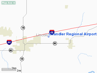
Location & QuickFacts
| FAA Information Effective: | 2008-09-25 |
| Airport Identifier: | CQB |
| Airport Status: | Operational |
| Longitude/Latitude: | 096-49-12.9830W/35-43-25.7360N
-96.820273/35.723816 (Estimated) |
| Elevation: | 984 ft / 299.92 m (Surveyed) |
| Land: | 80 acres |
| From nearest city: | 3 nautical miles NE of Chandler, OK |
| Location: | Lincoln County, OK |
| Magnetic Variation: | 06E (1995) |
Owner & Manager
| Ownership: | Publicly owned |
| Owner: | City Of Chandler |
| Address: | 414 Manvel
Chandler, OK 74834 |
| Phone number: | 405-258-3200 |
| Manager: | Rubin Pulis
CITY MANAGER. |
| Address: | 414 Manvel
Chandler, OK 74834 |
| Phone number: | 405-258-3200 |
Airport Operations and Facilities
| Airport Use: | Open to public |
| Wind indicator: | Yes |
| Segmented Circle: | Yes |
| Control Tower: | No |
| Lighting Schedule: | DUSK-DAWN |
| Beacon Color: | Clear-Green (lighted land airport) |
| Landing fee charge: | No |
| Sectional chart: | Dallas-ft Worth |
| Region: | ASW - Southwest |
| Boundary ARTCC: | ZKC - Kansas City |
| Tie-in FSS: | MLC - Mc Alester |
| FSS on Airport: | No |
| FSS Toll Free: | 1-800-WX-BRIEF |
| NOTAMs Facility: | CQB (NOTAM-d service avaliable) |
| Federal Agreements: | NGY |
Airport Communications
Airport Services
Runway Information
Runway 17/35
| Dimension: | 4000 x 60 ft / 1219.2 x 18.3 m |
| Surface: | ASPH, Fair Condition |
| Weight Limit: | Single wheel: 12500 lbs. |
| Edge Lights: | Medium |
| |
Runway 17 |
Runway 35 |
| Longitude: | 096-49-12.9110W | 096-49-13.1030W |
| Latitude: | 35-43-46.4740N | 35-43-06.9330N |
| Elevation: | 962.00 ft | 984.00 ft |
| Alignment: | 127 | 127 |
| Traffic Pattern: | Left | Left |
| Markings: | Non-precision instrument, Good Condition | Non-precision instrument, Good Condition |
| Crossing Height: | 31.00 ft | 30.00 ft |
| VASI: | 2-light PAPI on left side | 2-light PAPI on left side |
| Visual Glide Angle: | 3.00° | 2.50° |
| Obstruction: | 32 ft trees, 702.0 ft from runway, 15:1 slope to clear | , 50:1 slope to clear |
|
Radio Navigation Aids
| ID |
Type |
Name |
Ch |
Freq |
Var |
Dist |
| CQB | NDB | Tilghman | | 396.00 | 06E | 0.1 nm |
| CUH | NDB | Cushing | | 242.00 | 05E | 10.2 nm |
| GGU | NDB | Prague | | 314.00 | 06E | 13.4 nm |
| TZO | NDB | Bristow | | 251.00 | 05E | 19.5 nm |
| SRE | NDB | Seminole | | 278.00 | 06E | 28.1 nm |
| LCY | NDB | Logan County | | 326.00 | 07E | 29.9 nm |
| OK | NDB | Tuloo | | 406.00 | 07E | 41.3 nm |
| OWP | NDB | William Pogue | | 362.00 | 06E | 42.2 nm |
| OUN | NDB | Norman | | 260.00 | 07E | 42.8 nm |
| HDL | NDB | Holdenville | | 411.00 | 06E | 43.2 nm |
| HET | NDB | Henryetta | | 267.00 | 04E | 43.9 nm |
| TIK | TACAN | Tinker | 105X | | 07E | 32.3 nm |
| SWO | VOR/DME | Stillwater | 021X | 108.40 | 07E | 32.7 nm |
| PWA | VOR/DME | Wiley Post | 081X | 113.40 | 08E | 42.0 nm |
| GNP | VOR/DME | Glenpool | 043X | 110.60 | 06E | 43.2 nm |
| OKM | VOR/DME | Okmulgee | 096X | 114.90 | 08E | 46.6 nm |
| IRW | VORTAC | Will Rogers | 088X | 114.10 | 07E | 44.4 nm |
| OKC | VOT | Oklahoma Will Rgs W | | 108.80 | | 43.0 nm |
Images and information placed above are from
http://www.airport-data.com/airport/CQB/
We thank them for the data!
| General Info
|
| Country |
United States
|
| State |
OKLAHOMA
|
| FAA ID |
CQB
|
| Latitude |
35-43-25.736N
|
| Longitude |
096-49-12.983W
|
| Elevation |
984 feet
|
| Near City |
CHANDLER
|
We don't guarantee the information is fresh and accurate. The data may
be wrong or outdated.
For more up-to-date information please refer to other sources.
|
|


