 |
|
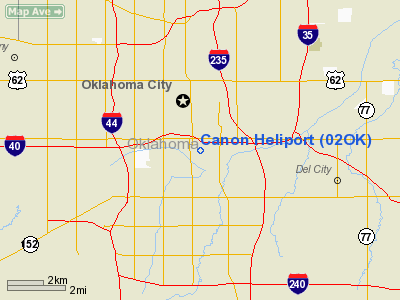
Location & QuickFacts
| FAA Information Effective: | 2008-09-25 |
| Airport Identifier: | 02OK |
| Airport Status: | Operational |
| Longitude/Latitude: | 097-31-31.1390W/35-27-30.2160N
-97.525316/35.458393 (Estimated) |
| Elevation: | 1191 ft / 363.02 m (Estimated) |
| Land: | 0 acres |
| From nearest city: | 2 nautical miles NE of Oklahoma City, OK |
| Location: | Oklahoma County, OK |
| Magnetic Variation: | 07E (1985) |
Owner & Manager
| Ownership: | Privately owned |
| Owner: | Jack O. Canon |
| Address: | 3712 Nw 48 Circle
Oklahoma City, OK 73112 |
| Phone number: | 405-942-1795 |
| Manager: | Jack O. Canon |
| Address: | 3712 Nw 48 Circle
Oklahoma City, OK 73112 |
| Phone number: | 405-942-1795 |
Airport Operations and Facilities
| Airport Use: | Private |
| Wind indicator: | Yes |
| Segmented Circle: | Yes |
| Control Tower: | No |
| Landing fee charge: | No |
| Sectional chart: | Dallas-ft Worth |
| Region: | ASW - Southwest |
| Boundary ARTCC: | ZFW - Fort Worth |
| Tie-in FSS: | MLC - Mc Alester |
| FSS on Airport: | No |
| FSS Toll Free: | 1-800-WX-BRIEF |
Runway Information
Helipad H1
| Dimension: | 70 x 60 ft / 21.3 x 18.3 m |
| Surface: | ASPH, |
| |
Runway H1 |
Runway |
| Traffic Pattern: | Left | Left |
|
Radio Navigation Aids
| ID |
Type |
Name |
Ch |
Freq |
Var |
Dist |
| OK | NDB | Tuloo | | 406.00 | 07E | 4.0 nm |
| OUN | NDB | Norman | | 260.00 | 07E | 12.9 nm |
| RQO | NDB | El Reno | | 335.00 | 07E | 23.7 nm |
| LCY | NDB | Logan County | | 326.00 | 07E | 23.9 nm |
| OLR | NDB | Chickasha | | 290.00 | 07E | 30.5 nm |
| CQB | NDB | Tilghman | | 396.00 | 06E | 38.0 nm |
| GGU | NDB | Prague | | 314.00 | 06E | 39.6 nm |
| SRE | NDB | Seminole | | 278.00 | 06E | 43.2 nm |
| CUH | NDB | Cushing | | 242.00 | 05E | 44.9 nm |
| PVJ | NDB | Pauls Valley | | 384.00 | 06E | 47.0 nm |
| TIK | TACAN | Tinker | 105X | | 07E | 7.3 nm |
| PWA | VOR/DME | Wiley Post | 081X | 113.40 | 08E | 7.5 nm |
| IRW | VORTAC | Will Rogers | 088X | 114.10 | 07E | 7.3 nm |
| IFI | VORTAC | Kingfisher | 094X | 114.70 | 09E | 31.3 nm |
| OKC | VOT | Oklahoma Will Rgs W | | 108.80 | | 5.3 nm |
Remarks
- CONDL--PROVIDED MUTUALLY AGREEABLE & COMPATIBLE TRAFFIC PATTERNS ARE ESTABLISHED BETWEEN CANON HELIPORT & DOWNTOWN AIRPARK; ALL INGRESS/EGRESS ROUTES MUST BE FROM/TO THE SOUTH & WEST QUADRANTS.
Images and information placed above are from
http://www.airport-data.com/airport/02OK/
We thank them for the data!
| General Info
|
| Country |
United States
|
| State |
OKLAHOMA
|
| FAA ID |
02OK
|
| Latitude |
35-27-30.216N
|
| Longitude |
097-31-31.139W
|
| Elevation |
1191 feet
|
| Near City |
OKLAHOMA CITY
|
We don't guarantee the information is fresh and accurate. The data may
be wrong or outdated.
For more up-to-date information please refer to other sources.
|
|


