 |
|
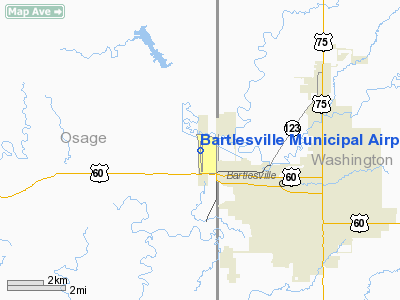
Bartlesville Muni Airport |
Location & QuickFacts
| FAA Information Effective: | 2008-09-25 |
| Airport Identifier: | BVO |
| Airport Status: | Operational |
| Longitude/Latitude: | 096-00-40.3250W/36-45-51.2950N
-96.011201/36.764249 (Estimated) |
| Elevation: | 711 ft / 216.71 m (Surveyed) |
| Land: | 430 acres |
| From nearest city: | 1 nautical miles NW of Bartlesville, OK |
| Location: | Osage County, OK |
| Magnetic Variation: | 07E (1980) |
Owner & Manager
| Ownership: | Publicly owned |
| Owner: | City Of Bartlesville |
| Address: | City Hall, 401 S. Johnstone
Bartlesville, OK 74003 |
| Phone number: | 918-338-4282 |
| Manager: | Phil Bates |
| Address: | Bartlesville Muni Arpt, 401 Nw Wiley Post Rd.
Bartlesville, OK 74003 |
| Phone number: | 918-661-6297 |
Airport Operations and Facilities
| Airport Use: | Open to public |
| Wind indicator: | Yes |
| Segmented Circle: | Yes |
| Control Tower: | No |
| Lighting Schedule: | DUSK-DAWN
ACTVT MIRL RY 17/35 & REIL RYS 17 & 35 - 120.0. ACTVT MALSR RY 17 - 123.0. |
| Beacon Color: | Clear-Green (lighted land airport) |
| Landing fee charge: | No |
| Sectional chart: | Kansas City |
| Region: | ASW - Southwest |
| Traffic Pattern Alt: | 1084 ft |
| Boundary ARTCC: | ZKC - Kansas City |
| Tie-in FSS: | MLC - Mc Alester |
| FSS on Airport: | No |
| FSS Toll Free: | 1-800-WX-BRIEF |
| NOTAMs Facility: | BVO (NOTAM-d service avaliable) |
| Federal Agreements: | NGY |
Airport Communications
| CTAF: | 120.000 |
| Unicom: | 123.000 |
Airport Services
| Fuel available: | 100LLA |
| Airframe Repair: | MINOR |
| Power Plant Repair: | MINOR |
Runway Information
Runway 17/35
| Dimension: | 6200 x 100 ft / 1889.8 x 30.5 m |
| Surface: | ASPH-CONC, Good Condition |
| Surface Treatment: | Saw-cut or plastic Grooved |
| Weight Limit: | Single wheel: 50000 lbs.
Dual wheel: 100000 lbs.
Dual tandem wheel: 170000 lbs. |
| Edge Lights: | Medium |
| |
Runway 17 |
Runway 35 |
| Longitude: | 096-00-41.0700W | 096-00-39.5800W |
| Latitude: | 36-46-21.9400N | 36-45-20.6500N |
| Elevation: | 685.00 ft | 711.00 ft |
| Alignment: | 127 | 127 |
| ILS Type: | LOCALIZER
| |
| Traffic Pattern: | Right | Left |
| Markings: | Non-precision instrument, Good Condition | Non-precision instrument, Good Condition |
| Crossing Height: | 53.00 ft | 45.00 ft |
| VASI: | 4-light PAPI on left side | 4-light PAPI on left side |
| Visual Glide Angle: | 3.00° | 3.00° |
| Approach lights: | MALSR | |
| Runway End Identifier: | Yes | Yes |
| Obstruction: | , 50:1 slope to clear | 45 ft trees, 1502.0 ft from runway, 28:1 slope to clear |
|
Radio Navigation Aids
| ID |
Type |
Name |
Ch |
Freq |
Var |
Dist |
| DW | NDB | Owaso | | 375.00 | 06E | 28.2 nm |
| CFV | NDB | Coffeyville | | 212.00 | 05E | 28.9 nm |
| OWP | NDB | William Pogue | | 362.00 | 06E | 36.2 nm |
| PPF | NDB | Parsons | | 258.00 | 06E | 42.1 nm |
| BVO | VOR/DME | Bartlesville | 126X | 117.90 | 08E | 4.2 nm |
| TUL | VORTAC | Tulsa | 091X | 114.40 | 08E | 35.8 nm |
| OSW | VORTAC | Oswego | 123X | 117.60 | 08E | 45.4 nm |
| TUL | VOT | Tulsa Intl | | 109.00 | | 35.8 nm |
Remarks
Images and information placed above are from
http://www.airport-data.com/airport/BVO/
We thank them for the data!
|
|


