 |
|
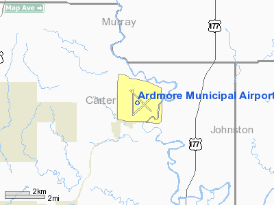
Ardmore Municipal Airport
Ardmore Industrial Airpark |
 |
| IATA: ADM – ICAO: KADM – FAA LID: ADM |
| Summary |
| Airport type |
Public |
| Operator |
Ardmore Development Authority |
| Serves |
Ardmore, Oklahoma |
| Elevation AMSL |
762 ft / 232 m |
| Coordinates |
34°18′12″N 97°01′10″W / 34.30333°N 97.01944°W / 34.30333; -97.01944 |
| Runways |
| Direction |
Length |
Surface |
| ft |
m |
| 13/31 |
7,220 |
2,201 |
Asphalt |
| 17/35 |
5,006 |
1,526 |
Asphalt |
Ardmore AAF - 1945 Ardmore Municipal Airport (IATA: ADM, ICAO: KADM, FAA LID: ADM), also known as Ardmore Industrial Airpark, is a general aviation airport located 10 miles (16 km) northeast of the central business district of Ardmore, (near Gene Autry, OK) cities in Carter County, Oklahoma, United States. Facilities
Ardmore Municipal Airport covers 2,503 acres (1,013 ha) and has two runways:
- Runway 13/31: 7,220 x 150 ft (2,201 x 46 m), Surface: Asphalt to be expanded to 9,000 ft)
- Runway 17/35: 5,006 x 100 ft (1,526 x 30 m), Surface: Asphalt
The airport has an FAA staffed control tower, full instrumentation, parking capacity for up to 100 commercial sized aircraft and over 36,000 sq ft (3,300 m). of hangar space. The associated industrial park has over 2,900 acres (12 km), with Burlington Northern Santa Fe providing a spur into the park.
Current industries at the Airpark including King Aerospace, Higgins Interiors, Inc., Dollar General Distribution Center, East Jordan Iron Works, Carbonyx, Inc., and Online Packaging.
History
The airport is located on the site of the former Ardmore Army Air Field' from 1942 to 1946 and later Ardmore Air Force Base from 1953 to 1959.
The above content comes from Wikipedia and is published under free licenses – click here to read more.
 |
(Click on the photo to enlarge) |
Location & QuickFacts
| FAA Information Effective: | 2008-09-25 |
| Airport Identifier: | ADM |
| Airport Status: | Operational |
| Longitude/Latitude: | 097-01-10.6830W/34-18-10.8360N
-97.019634/34.303010 (Estimated) |
| Elevation: | 762 ft / 232.26 m (Surveyed) |
| Land: | 2503 acres |
| From nearest city: | 10 nautical miles NE of Ardmore, OK |
| Location: | Carter County, OK |
| Magnetic Variation: | 06E (1995) |
Owner & Manager
| Ownership: | Publicly owned |
| Owner: | City Of Ardmore |
| Address: | Po Box 249
Ardmore, OK 73402 |
| Phone number: | 580-223-2933 |
| Manager: | Roy Givens |
| Address: | 620 General Dr., Suite 2
Ardmore, OK 73401 |
| Phone number: | 580-389-5238
ADDNL PHONE NR 580-389-5238/ARDMORE DEV AUTHORITY. |
Airport Operations and Facilities
| Airport Use: | Open to public |
| Wind indicator: | Yes |
| Segmented Circle: | Yes |
| Control Tower: | Yes |
| Lighting Schedule: | DUSK-DAWN
ACTVT HIRL RYS 13/31 & 17/35 AND MALSR RY 31 - CTAF. |
| Beacon Color: | Clear-Green (lighted land airport) |
| Landing fee charge: | No |
| Sectional chart: | Dallas-ft Worth |
| Region: | ASW - Southwest |
| Boundary ARTCC: | ZFW - Fort Worth |
| Tie-in FSS: | MLC - Mc Alester |
| FSS on Airport: | No |
| FSS Toll Free: | 1-800-WX-BRIEF |
| NOTAMs Facility: | ADM (NOTAM-d service avaliable) |
| Federal Agreements: | NGPY |
Airport Communications
| CTAF: | 118.500 |
| Unicom: | 122.950 |
Airport Services
| Fuel available: | 100LLA |
| Airframe Repair: | MINOR |
| Power Plant Repair: | MINOR |
Runway Information
Runway 13/31
| Dimension: | 7220 x 150 ft / 2200.7 x 45.7 m |
| Surface: | ASPH, Good Condition |
| Weight Limit: | Single wheel: 24000 lbs. |
| Edge Lights: | High |
| |
Runway 13 |
Runway 31 |
| Longitude: | 097-01-30.3780W | 097-00-29.9660W |
| Latitude: | 34-18-40.5100N | 34-17-49.6480N |
| Elevation: | 762.00 ft | 729.00 ft |
| Alignment: | 127 | 127 |
| ILS Type: | | ILS
|
| Traffic Pattern: | Left | Left |
| Markings: | Non-precision instrument, Good Condition | Precision instrument, Good Condition |
| Crossing Height: | 58.00 ft | 52.00 ft |
| VASI: | 4-box on left side | 4-box on left side |
| Visual Glide Angle: | 3.50° | 3.00° |
| Approach lights: | | MALSR |
| Obstruction: | 70 ft trees, 1480.0 ft from runway, 18:1 slope to clear | 60 ft trees, 1650.0 ft from runway, 24:1 slope to clear |
|
Runway 17/35
| Dimension: | 5350 x 100 ft / 1630.7 x 30.5 m |
| Surface: | ASPH, |
| Weight Limit: | Single wheel: 36000 lbs. |
| Edge Lights: | High |
| |
Runway 17 |
Runway 35 |
| Longitude: | 097-01-24.6360W | 097-01-25.0998W |
| Latitude: | 34-18-31.5700N | 34-17-38.6501N |
| Elevation: | 753.00 ft | 725.00 ft |
| Alignment: | 127 | 0 |
| Traffic Pattern: | Left | Left |
| Markings: | Basic, Good Condition | Basic, Good Condition |
| Obstruction: | 75 ft trees, 1800.0 ft from runway, 21:1 slope to clear | 60 ft trees, 1650.0 ft from runway, 200 ft right of centerline, 24:1 slope to clear |
|
Radio Navigation Aids
| ID |
Type |
Name |
Ch |
Freq |
Var |
Dist |
| AUV | NDB | Arbuckle | | 284.00 | 07E | 10.5 nm |
| PVJ | NDB | Pauls Valley | | 384.00 | 06E | 26.9 nm |
| DNI | NDB | Denison | | 341.00 | 06E | 33.7 nm |
| GLE | NDB | Gainesville | | 330.00 | 06E | 36.2 nm |
| DUA | NDB | Durant | | 359.00 | 05E | 37.7 nm |
| ADH | VOR/DME | Ada | 125X | 117.80 | 06E | 34.7 nm |
| URH | VOR/DME | Texoma | 090X | 114.30 | 05E | 38.0 nm |
| DUC | VOR/DME | Duncan | 047X | 111.00 | 09E | 44.8 nm |
| ADM | VORTAC | Ardmore | 114X | 116.70 | 06E | 9.2 nm |
Remarks
- DEER ON & INVOF ARPT.
- TOWER 37 FT AGL 800 FT EAST OF RY 31.
- CONSTRUCTED PRIOR TO AIRSPACE REQUIREMENTS
Images and information placed above are from
http://www.airport-data.com/airport/ADM/
We thank them for the data!
| General Info
|
| Country |
United States
|
| State |
OKLAHOMA
|
| FAA ID |
ADM
|
| Latitude |
34-18-11.544N
|
| Longitude |
097-01-10.278W
|
| Elevation |
762 feet
|
| Near City |
ARDMORE
|
We don't guarantee the information is fresh and accurate. The data may
be wrong or outdated.
For more up-to-date information please refer to other sources.
|
|


