 |
|
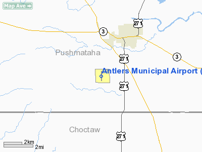
| Antlers Municipal Airport |
| IATA: ATE – ICAO: none – FAA LID: 80F |
| Summary |
| Airport type |
Public |
| Owner |
City of Antlers |
| Serves |
Antlers, Oklahoma |
| Elevation AMSL |
575 ft / 175 m |
| Coordinates |
34°11′33″N 095°38′59″W / 34.1925°N 95.64972°W / 34.1925; -95.64972 |
| Runways |
| Direction |
Length |
Surface |
| ft |
m |
| 17/35 |
3,299 |
1,006 |
Asphalt |
| Statistics (2006) |
| Aircraft operations |
600 |
| Source: Federal Aviation Administration |
Antlers Municipal Airport (IATA: ATE, FAA LID: 80F) is a public airport located one mile (2 km) southwest of the central business district of Antlers, a city in Pushmataha County, Oklahoma, United States. It is owned by the City of Antlers.
Facilities and aircraft
Antlers Municipal Airport covers an area of 84 acres (34 ha) which contains one asphalt paved runway (17/35) measuring 3,299 x 60 ft (1,006 x 18 m). For the 12-month period ending May 15, 2006, the airport had 600 aircraft operations, all of which were general aviation.
The above content comes from Wikipedia and is published under free licenses – click here to read more.
Location & QuickFacts
| FAA Information Effective: | 2008-09-25 |
| Airport Identifier: | 80F |
| Airport Status: | Operational |
| Longitude/Latitude: | 095-38-59.4920W/34-11-33.3630N
-95.649859/34.192601 (Estimated) |
| Elevation: | 575 ft / 175.26 m (Surveyed) |
| Land: | 84 acres |
| From nearest city: | 1 nautical miles SW of Antlers, OK |
| Location: | Pushmataha County, OK |
| Magnetic Variation: | 05E (2000) |
Owner & Manager
| Ownership: | Publicly owned |
| Owner: | City Of Antlers |
| Address: | City Hall, 100 Sw 2nd St
Antlers, OK 74523 |
| Phone number: | 580-298-5635 |
| Manager: | Joel Taylor
CITY MANAGER. |
| Address: | City Hall, 100 Sw 2nd St
Antlers, OK 74523 |
| Phone number: | 580-298-5635 |
Airport Operations and Facilities
| Airport Use: | Open to public |
| Wind indicator: | Yes |
| Segmented Circle: | Yes |
| Control Tower: | No |
| Lighting Schedule: | DUSK-DAWN
ACTVT MIRL RY 17/35 - CTAF. |
| Beacon Color: | Clear-Green (lighted land airport) |
| Landing fee charge: | No |
| Sectional chart: | Dallas-ft Worth |
| Region: | ASW - Southwest |
| Boundary ARTCC: | ZFW - Fort Worth |
| Tie-in FSS: | MLC - Mc Alester |
| FSS on Airport: | No |
| FSS Toll Free: | 1-800-WX-BRIEF |
| NOTAMs Facility: | MLC (NOTAM-d service avaliable) |
| Federal Agreements: | NGY |
Airport Communications
Airport Services
| Bottled Oxygen: | NONE |
| Bulk Oxygen: | NONE |
Runway Information
Runway 17/35
| Dimension: | 3299 x 60 ft / 1005.5 x 18.3 m |
| Surface: | ASPH, Poor Condition
RY HAS MODERATE TO SEVERE CRACKING. |
| Weight Limit: | Single wheel: 12000 lbs. |
| Edge Lights: | Medium |
| |
Runway 17 |
Runway 35 |
| Longitude: | 095-38-59.5740W | 095-38-59.4430W |
| Latitude: | 34-11-49.6890N | 34-11-17.0590N |
| Elevation: | 574.00 ft | 569.00 ft |
| Alignment: | 127 | 127 |
| Traffic Pattern: | Left | Left |
| Markings: | Non-precision instrument, Good Condition | Non-precision instrument, Good Condition |
| Obstruction: | 70 ft trees, 1230.0 ft from runway, 14:1 slope to clear | 55 ft trees, 840.0 ft from runway, 325 ft right of centerline, 11:1 slope to clear |
|
Radio Navigation Aids
| ID |
Type |
Name |
Ch |
Freq |
Var |
Dist |
| AEE | NDB | Antlers | | 391.00 | 05E | 0.1 nm |
| HHW | NDB | Hugo | | 323.00 | 05E | 10.7 nm |
| DUA | NDB | Durant | | 359.00 | 05E | 40.3 nm |
| HJM | NDB | Rayburn | | 415.00 | 06E | 43.6 nm |
| IBO | NDB | Idabel | | 271.00 | 03E | 43.7 nm |
| URH | VOR/DME | Texoma | 090X | 114.30 | 05E | 39.8 nm |
| PRX | VOR/DME | Paris | 083X | 113.60 | 07E | 40.4 nm |
| MLC | VORTAC | Mc Alester | 057X | 112.00 | 08E | 40.0 nm |
| BYP | VORTAC | Bonham | 093X | 114.60 | 06E | 49.0 nm |
Images and information placed above are from
http://www.airport-data.com/airport/80F/
We thank them for the data!
| General Info
|
| Country |
United States
|
| State |
OKLAHOMA
|
| FAA ID |
80F
|
| Latitude |
34-11-33.363N
|
| Longitude |
095-38-59.492W
|
| Elevation |
575 feet
|
| Near City |
ANTLERS
|
We don't guarantee the information is fresh and accurate. The data may
be wrong or outdated.
For more up-to-date information please refer to other sources.
|
|


