 |
|
Youngstown-warren Rgnl Airport |
Youngstown-Warren Regional Airport
Youngstown-Warren Air Reserve Station |
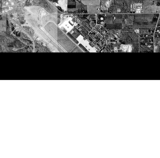 |
| USGS aerial image - 20 April 1994 |
| IATA: YNG – ICAO: KYNG – FAA LID: YNG |
| Summary |
| Airport type |
Public |
| Owner |
Western Reserve Port Authority |
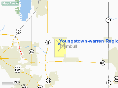
| Serves |
Youngstown / Warren, Ohio |
| Elevation AMSL |
1,196 ft / 365 m |
| Coordinates |
41°15′39″N 080°40′45″W / 41.26083°N 80.67917°W / 41.26083; -80.67917 |
| Website |
www.yngairport.com |
| Runways |
| Direction |
Length |
Surface |
| ft |
m |
| 5/23 |
5,002 |
1,525 |
Asphalt |
| 14/32 |
9,003 |
2,744 |
Asphalt |
| 143/323 |
3,500 |
1,067 |
Asphalt |
| Statistics (2008) |
| Aircraft operations |
60,845 |
| Based aircraft |
43 |
| Source: Federal Aviation Administration |
Logo of Youngstown-Warren Regional Airport Youngstown-Warren Regional Airport (IATA: YNG, ICAO: KYNG, FAA LID: YNG) is a public and military use airport in Trumbull County, Ohio, United States. It is 10 nautical miles (19 km) north of the central business district of Youngstown and 10 miles (16 km) east of Warren. The airport is located in Vienna, Ohio and it is also home to the Youngstown-Warren Air Reserve Station.
The airport has been open for over 50 years and serves the Mahoning and Shenango (Steel) Valleys, and the Penn-Ohio Area (Northeast Ohio and Western Pennsylvania). It is run by the Western Reserve Port Authority, which is made up of members appointed by the Mahoning and Trumbull County Commissioners. The WRPA also plays a vital role in the regional economy as it is teamed up with the Youngstown-Warren Regional Chamber of Commerce and is leading the role of cleaning up the Mahoning River. History
The Youngstown-Warren Regional Airport began as the Youngstown Municipal Airport (MAP), having been constructed as one of the last Works Progress Administration projects. Construction began in 1939 and the airport was operational just a year later. The airport is located 11 miles (18 km) north of Youngstown in Vienna Center because during the 1930s and 40's, there was little room inside the city limits for an airport the size of the one planned. The airport that had been serving the city, Lansdowne Airport, lacked the room to expand.
At one time, US Airways, United Airlines, Continental Airlines, Northwest Airlines, Pan Am and Vacation Express have all serviced the airport. For some time in the early 2000s the airport had no scheduled commercial service, but in 2006 Allegiant Air began scheduled service to Orlando, Florida bringing commercial air service back to Youngstown. Other local airports include Cleveland Hopkins International Airport, Akron-Canton Regional Airport, Erie International Airport and the Pittsburgh International Airport.
Youngstown-Warren Air Reserve StationYoungstown ARS is located at the Youngstown-Warren Regional Airport. Its primary mission is to serve as home of the 910th Airlift Wing, an Air Force Reserve Command C-130H unit with two flying squadrons and a total of 16 aircraft. A portion of the Wing is devoted to its aerial spray mission. The Wing has nearly 1,300 drilling Air Force Reservists. The installation also hosts a Navy Operational Support Center and a Marine Corps Reserve Center that is home to nearly 400 Navy and Marine Corps Reservists in various units. It is also home to the Youngstown ARS Composite Squadron of the Civil Air Patrol.
Facilities and aircraft
Youngstown-Warren Regional Airport covers an area of 1,468 acres (594 ha) at an elevation of 1,196 feet (365 m) above mean sea level. It has three asphalt paved runways: 5/23 is 5,002 by 150 feet (1,525 x 46 m); 14/32 is 9,003 by 150 feet (2,744 x 46 m); 143/323 is 3,500 by 60 feet (1,067 x 18 m).
The Youngstown-Warren Regional Airport Terminal sits on the southeast end of the airport. In the year 2000, the terminal was renovated and expanded. The terminal has room for five airline ticket counters. The new addition, from the year 2000, expanded the airports gates from two to six and includes one jetway. The terminal provides seating for over 250,000 annually and can seat up to 300 at any given time.
For the 12-month period ending December 31, 2008, the airport had 60,845 aircraft operations, an average of 166 per day: 59% general aviation, 38% military, 3% air taxi and <1% scheduled commercial. At that time there were 43 aircraft based at this airport: 47% single-engine, 19% multi-engine, 7% jet and 28% military.
Airline and destinations
| Airlines |
Destinations |
| Allegiant Air |
Myrtle Beach, Orlando-International, St. Petersburg [begins November 17] |
The above content comes from Wikipedia and is published under free licenses – click here to read more.
Location & QuickFacts
| FAA Information Effective: | 2008-09-25 |
| Airport Identifier: | YNG |
| Airport Status: | Operational |
| Longitude/Latitude: | 080-40-44.7480W/41-15-38.6480N
-80.679097/41.260736 (Estimated) |
| Elevation: | 1196 ft / 364.54 m (Surveyed) |
| Land: | 1468 acres |
| From nearest city: | 10 nautical miles N of Youngstown/warren, OH |
| Location: | Trumbull County, OH |
| Magnetic Variation: | 08W (1990) |
Owner & Manager
| Ownership: | Publicly owned |
| Owner: | Western Res Port Auth |
| Address: | 1453 Youngstown-kingsville Rd
Vienna, OH 44473-9797 |
| Phone number: | 330-539-4233 |
| Manager: | Stephen Bowser |
| Address: | 1453 Youngstown-kingsville Rd
Vienna, OH 44473-9797 |
| Phone number: | 330-539-4233 |
Airport Operations and Facilities
| Airport Use: | Open to public |
| Wind indicator: | Yes |
| Segmented Circle: | No |
| Control Tower: | Yes |
| Lighting Schedule: | DUSK-DAWN |
| Beacon Color: | Clear-Green (lighted land airport) |
| Landing fee charge: | Yes
LNDG FEE FOR ACFT OVER 5000 LBS GWT. |
| Sectional chart: | Detroit |
| Region: | AGL - Great Lakes |
| Boundary ARTCC: | ZOB - Cleveland |
| Tie-in FSS: | CLE - Cleveland |
| FSS on Airport: | No |
| FSS Toll Free: | 1-800-WX-BRIEF |
| NOTAMs Facility: | YNG (NOTAM-d service avaliable) |
| Certification type/date: | I B S 05/1973
PPR FOR ARFF INDEX 'D' CALL 330-609-1369. |
| Federal Agreements: | NGY3 |
Airport Communications
Airport Services
| Fuel available: | 100LLA |
| Airframe Repair: | MAJOR |
| Power Plant Repair: | MAJOR |
| Bottled Oxygen: | HIGH/LOW |
| Bulk Oxygen: | HIGH/LOW |
Runway Information
Runway 05/23
| Dimension: | 5002 x 150 ft / 1524.6 x 45.7 m |
| Surface: | ASPH, Good Condition |
| Surface Treatment: | Saw-cut or plastic Grooved |
| Weight Limit: | Single wheel: 138000 lbs.
Dual wheel: 175000 lbs.
Dual tandem wheel: 280000 lbs. |
| Edge Lights: | Medium |
| |
Runway 05 |
Runway 23 |
| Longitude: | 080-40-56.9550W | 080-40-10.6680W |
| Latitude: | 41-14-58.9980N | 41-15-33.9650N |
| Elevation: | 1123.00 ft | 1192.00 ft |
| Alignment: | 45 | 127 |
| Traffic Pattern: | Left | Left |
| Markings: | Non-precision instrument, Good Condition | Non-precision instrument, Good Condition |
| Crossing Height: | 51.00 ft | 24.00 ft |
| VASI: | 4-box on left side | 4-light PAPI on right side |
| Visual Glide Angle: | 3.25° | 3.00° |
| Runway End Identifier: | Yes | Yes |
| Obstruction: | 94 ft trees, 1749.0 ft from runway, 398 ft left of centerline, 16:1 slope to clear | , 50:1 slope to clear |
|
Runway 14/32
| Dimension: | 9003 x 150 ft / 2744.1 x 45.7 m |
| Surface: | ASPH, Good Condition |
| Surface Treatment: | Saw-cut or plastic Grooved |
| Weight Limit: | Single wheel: 140000 lbs.
Dual wheel: 209000 lbs.
Dual tandem wheel: 340000 lbs.
Dual dual tandem wheel: 600000 lbs. |
| Edge Lights: | High |
| |
Runway 14 |
Runway 32 |
| Longitude: | 080-41-32.4591W | 080-40-09.0521W |
| Latitude: | 41-16-22.3767N | 41-15-19.5305N |
| Elevation: | 1107.00 ft | 1185.00 ft |
| Alignment: | 127 | 127 |
| ILS Type: | ILS
| ILS
|
| Traffic Pattern: | Left | Left |
| Markings: | Precision instrument, Good Condition | Precision instrument, Good Condition |
| Crossing Height: | 57.00 ft | 40.00 ft |
| VASI: | 4-light PAPI on left side | 4-light PAPI on left side |
| Visual Glide Angle: | 3.00° | 3.00° |
| RVR Equipment: | | touchdown |
| Approach lights: | MALSR | MALSR |
| Obstruction: | , 50:1 slope to clear | 37 ft trees, 1689.0 ft from runway, 485 ft right of centerline, 40:1 slope to clear |
|
Runway 143/323
| Dimension: | 3500 x 60 ft / 1066.8 x 18.3 m |
| Surface: | ASPH, Fair Condition |
| |
Runway 143 |
Runway 323 |
| Traffic Pattern: | Left | Left |
|
Radio Navigation Aids
| ID |
Type |
Name |
Ch |
Freq |
Var |
Dist |
| HBD | NDB | Hubbard | | 408.00 | 08W | 9.3 nm |
| UCP | NDB | Castle | | 272.00 | 09W | 18.6 nm |
| AK | NDB | Akron | | 362.00 | 07W | 34.0 nm |
| LQL | NDB | Lakeland | | 263.00 | 08W | 40.4 nm |
| TSO | NDB | Tolson | | 395.00 | 07W | 45.7 nm |
| BKL | NDB | Burke Lakefront | | 416.00 | 07W | 47.2 nm |
| EZE | NDB | Engel | | 226.00 | 07W | 49.0 nm |
| FKL | VOR | Franklin | | 109.60 | 06W | 38.6 nm |
| ACO | VOR/DME | Akron | 091X | 114.40 | 04W | 25.4 nm |
| CXR | VOR/DME | Chardon | 074X | 112.70 | 05W | 26.7 nm |
| JFN | VOR/DME | Jefferson | 099X | 115.20 | 05W | 30.2 nm |
| LNN | VOR/DME | Lost Nation | 039X | 110.20 | 08W | 40.9 nm |
| BSV | VOR/DME | Briggs | 071X | 112.40 | 04W | 46.3 nm |
| YNG | VORTAC | Youngstown | 027X | 109.00 | 05W | 4.2 nm |
| EWC | VORTAC | Ellwood City | 105X | 115.80 | 08W | 33.7 nm |
| ERI | VORTAC | Erie | 031X | 109.40 | 06W | 48.7 nm |
| CAK | VOT | Akron/canton Regional | | 110.60 | | 40.3 nm |
Remarks
- TWY 'G' E OF TWY 'H' & TWY 'F' N OF RY 05/23 CLSD TO ACFT OVR 50,000 LBS GROSS WEIGHT.
- RSTD: MIL LANDING ZONE 143*-323* FOR MIL USE ONLY. NO PRACTICE APCH 0300-1300Z++. AFRC ACFT OPR RSTD DUR BIRD WATCH CON MODERATE (TKOF OR LDG PERMS ONLY WHEN DEP AND ARR RTE AVOID IDENT BIRD ACT, NO LCL IFR/VFR TFC PAT ACT) AND SEVERE (TKOF AND LDG PROH WO OG/CC APVL).
- MISC: FBO LINE SVC AVBL 1100-0400Z++, OT FONE C330-856-5000.
- AFRC: PPR FOR RAMP AND MIL LZ CTC BASE OPS 1230-0400Z++ MON-FRI EXC HOL (DT 1130-0400Z) AND DUR UNIT TRNG SAT 1300-2200Z++ AND SUN 1200-2100Z++. FOR RAMP PPR PN48HRS CTC BASE OPS DSN 346-1069/1181. BASE OPS OPEN 1230-0400Z++ MON -FRI EXC HOL AND DUR UNIT TRNG SAT 1300-2200Z++ AND SUN 1200-2100Z++.
- AFRC: NO TRANS ALERT SVC. INBD MIL ACFT INDICATE IN RMK DD FORM 175 WHETHER PRK WILL BE ON CIV OR MIL RAMP. TRANS ACFT RQR MAINT WILL BE RECOVERED BY HOME BASE. ACFT SECURITY NOT AVBL FOR C5 RON EXC EMERG.
- AFRC: MIL LANDING ZONE 323 1.4% DOWNSLOPE. RWY 143 1.4% UPSLOPE. SEE FLIP AP/1 SUPPLEMENTARY ARPT RMK.
- FUEL: J8+100(MIL) J8(PN REQ) (NC-100LL,A).
- FLUID: LOX (MIL).
- OIL: O -156
- TERMINAL RAMP AND GENERAL AVIATION PARKING NOT VIS FR THE NW PORTION OF TWY H. MILITARY RAMP FOR MILITARY USE ONLY.
- DEER & BIRD HAZARD. ALL MIL ACFT CTC VADER OPS FOR BIRD WATCH COND.
- TWY 'T' W OF RY 5/23 CLSD INDEFLY.
Images and information placed above are from
http://www.airport-data.com/airport/YNG/
We thank them for the data!
| General Info
|
| Country |
United States
|
| State |
OHIO
|
| FAA ID |
YNG
|
| Latitude |
41-15-38.648N
|
| Longitude |
080-40-44.748W
|
| Elevation |
1196 feet
|
| Near City |
YOUNGSTOWN/WARREN
|
We don't guarantee the information is fresh and accurate. The data may
be wrong or outdated.
For more up-to-date information please refer to other sources.
|
|


