 |
|
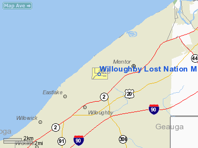
Willoughby Lost Nation Muni Airport |
| Willoughby Lost Nation Municipal Airport |
| IATA: LNN – ICAO: KLNN – FAA LID: LNN |
| Summary |
| Airport type |
Public |
| Owner |
City of Willoughby |
| Serves |
Willoughby, Ohio |
| Elevation AMSL |
626 ft / 191 m |
| Coordinates |
41°41′02.5″N 081°23′23.1″W / 41.684028°N 81.38975°W / 41.684028; -81.38975 |
| Runways |
| Direction |
Length |
Surface |
| ft |
m |
| 05/23 |
5,028 |
1,533 |
Asphalt |
| 10/28 |
4,272 |
1,302 |
Asphalt |
| Statistics (2008) |
| Aircraft operations |
45,085 |
| Based aircraft |
88 |
| Source: Federal Aviation Administration |
Willoughby Lost Nation Municipal Airport is a public use airport in Lake County, Ohio, United States. It is owned by the City of Willoughby and is located three nautical miles (5.56 km) northeast of its central business district. According to the FAA's National Plan of Integrated Airport Systems for 2007-2011, it is categorized as a reliever airport.
Facilities and aircraft
Willoughby Lost Nation Municipal Airport covers an area of 400 acres (162 ha) at an elevation of 626 feet (191 m) above mean sea level. It has two asphalt runways designated 05/23, with a surface measuring 5,028 by 100 feet (1,533 x 30 m) and 10/28, with a surface measuring 4,272 by 100 feet (1,302 x 30 m).
For the 12-month period ending August 7, 2008, the airport had 45,085 aircraft operations, an average of 124 per day: 97% general aviation, 3% air taxi and a few military. At that time there were 88 aircraft based at this airport: 78% single-engine, 18% multi-engine and 3% jets.
The above content comes from Wikipedia and is published under free licenses – click here to read more.
Location & QuickFacts
| FAA Information Effective: | 2008-09-25 |
| Airport Identifier: | LNN |
| Airport Status: | Operational |
| Longitude/Latitude: | 081-23-23.1000W/41-41-02.5000N
-81.389750/41.684028 (Estimated) |
| Elevation: | 626 ft / 190.80 m (Surveyed) |
| Land: | 400 acres |
| From nearest city: | 3 nautical miles N of Willoughby, OH |
| Location: | Lake County, OH |
| Magnetic Variation: | 08W (1995) |
Owner & Manager
| Ownership: | Publicly owned |
| Owner: | City Of Willoughby |
| Address: | One Public Square
Willoughby, OH 44094 |
| Phone number: | 440-951-2800 |
| Manager: | Daniel R. Kozar |
| Address: | 38550 Jet Center Drive
Willoughby, OH 44094 |
| Phone number: | 440-953-4372 |
Airport Operations and Facilities
| Airport Use: | Open to public |
| Wind indicator: | Yes |
| Segmented Circle: | No |
| Control Tower: | No |
| Lighting Schedule: | DUSK-DAWN
ACTVT MIRL RYS 05/23 & 10/28; REIL RYS 05; 23; 10 & 28; AND PAPI RYS 05; 23; 10 & 28 - CTAF. |
| Beacon Color: | Clear-Green (lighted land airport) |
| Sectional chart: | Detroit |
| Region: | AGL - Great Lakes |
| Boundary ARTCC: | ZOB - Cleveland |
| Tie-in FSS: | CLE - Cleveland |
| FSS on Airport: | No |
| FSS Toll Free: | 1-800-WX-BRIEF |
| NOTAMs Facility: | CLE (NOTAM-d service avaliable) |
| Federal Agreements: | NGY |
Airport Communications
| CTAF: | 122.725 |
| Unicom: | 122.725 |
Airport Services
| Fuel available: | 100LLA
FOR FUEL AFTER HRS CALL 216-953-2929. |
| Airframe Repair: | MAJOR |
| Power Plant Repair: | MAJOR |
| Bulk Oxygen: | HIGH/LOW |
Runway Information
Runway 05/23
| Dimension: | 5028 x 100 ft / 1532.5 x 30.5 m |
| Surface: | ASPH, Good Condition |
| Weight Limit: | Single wheel: 68000 lbs.
Dual wheel: 80000 lbs.
Dual tandem wheel: 124000 lbs. |
| Edge Lights: | Medium |
| |
Runway 05 |
Runway 23 |
| Longitude: | 081-23-50.7787W | 081-23-04.2558W |
| Latitude: | 41-40-49.5286N | 41-41-24.8987N |
| Elevation: | 624.00 ft | 620.00 ft |
| Alignment: | 45 | 127 |
| Traffic Pattern: | Left | Left |
| Markings: | Non-precision instrument, Good Condition | Non-precision instrument, Good Condition |
| Displaced threshold: | 428.00 ft | 0.00 ft |
| VASI: | 4-light PAPI on right side | 4-light PAPI on left side
OTS INDEFLY. |
| Runway End Identifier: | Yes
OTS INDEFLY. | Yes
OTS INDEFLY. |
| Obstruction: | 44 ft pole, 696.0 ft from runway, 256 ft left of centerline, 11:1 slope to clear
RWY 05 19:1 TO DISPLACED THRESHOLD, DUE TO +108 TREES 2108 FM DISPLACED THRESHOLD 125R. | 61 ft trees, 880.0 ft from runway, 270 ft left of centerline, 11:1 slope to clear |
|
Runway 10/28
| Dimension: | 4272 x 100 ft / 1302.1 x 30.5 m |
| Surface: | ASPH, Good Condition |
| Weight Limit: | Single wheel: 68000 lbs.
Dual wheel: 80000 lbs.
Dual tandem wheel: 124000 lbs. |
| Edge Lights: | Medium |
| |
Runway 10 |
Runway 28 |
| Longitude: | 081-23-46.0283W | 081-22-49.7287W |
| Latitude: | 41-40-57.0654N | 41-40-56.6913N |
| Elevation: | 624.00 ft | 624.00 ft |
| Alignment: | 91 | 127 |
| Traffic Pattern: | Left | Left |
| Markings: | Non-precision instrument, Fair Condition | Non-precision instrument, Fair Condition |
| Displaced threshold: | 0.00 ft | 1124.00 ft |
| VASI: | 2-light PAPI on left side | 2-light PAPI on left side |
| Runway End Identifier: | Yes | Yes |
| Obstruction: | 81 ft trees, 1200.0 ft from runway, 96 ft right of centerline, 12:1 slope to clear
APCH RATIO 18:1 OVER ADDL OBSTN +66 FT TREES 1217 FT FM THLD 74 FT R. | 36 ft poles, 408.0 ft from runway, 136 ft left of centerline, 5:1 slope to clear
RWY 28 APPROACH 7:1 TO DISPLACED THRESHOLD DUE TO 72' TREES 512' FM DISPLACED THRESHOLD 314L. |
|
Radio Navigation Aids
| ID |
Type |
Name |
Ch |
Freq |
Var |
Dist |
| LQL | NDB | Lakeland | | 263.00 | 08W | 0.5 nm |
| BKL | NDB | Burke Lakefront | | 416.00 | 07W | 15.4 nm |
| EZE | NDB | Engel | | 226.00 | 07W | 19.0 nm |
| CL | NDB | Harri | | 344.00 | 07W | 33.2 nm |
| AK | NDB | Akron | | 362.00 | 07W | 36.9 nm |
| 4L | NDB | Chatham | | 236.00 | 06W | 48.7 nm |
| CXR | VOR/DME | Chardon | 074X | 112.70 | 05W | 14.3 nm |
| JFN | VOR/DME | Jefferson | 099X | 115.20 | 05W | 29.1 nm |
| ACO | VOR/DME | Akron | 091X | 114.40 | 04W | 35.7 nm |
| DJB | VOR/DME | Dryer | 083X | 113.60 | 05W | 39.9 nm |
| YNG | VORTAC | Youngstown | 027X | 109.00 | 05W | 38.6 nm |
| CLE | VOT | Cleveland | | 110.40 | | 26.4 nm |
| CAK | VOT | Akron/canton Regional | | 110.60 | | 46.2 nm |
Remarks
- DEER AND BIRDS ON AND INVOF ARPT.
- N & S TWY CLSD TO ACFT OVER 12500 LBS BETWEEN RYS 05 & 10 THLD.
- MULTIPLE PRACTICE LNDG & TKOF PROHIBITED MON-FRI 2300-0800; SAT-SUN & HOLS 2300-0900.
Images and information placed above are from
http://www.airport-data.com/airport/LNN/
We thank them for the data!
| General Info
|
| Country |
United States
|
| State |
OHIO
|
| FAA ID |
LNN
|
| Latitude |
41-41-02.500N
|
| Longitude |
081-23-23.100W
|
| Elevation |
626 feet
|
| Near City |
WILLOUGHBY
|
We don't guarantee the information is fresh and accurate. The data may
be wrong or outdated.
For more up-to-date information please refer to other sources.
|
|


