|
 |
|
||||
|
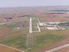
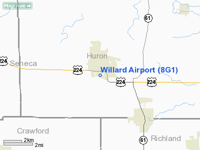
University of Illinois Willard Airport (IATA: CMI, ICAO: KCMI, FAA LID: CMI) is an airport owned and operated by the University of Illinois at Urbana-Champaign located south of Savoy in Tolono Township, Champaign County, Illinois. It serves the greater Champaign-Urbana Metropolitan Area in East Central Illinois. Willard Airport is named for former University of Illinois president Arthur Cutts Willard, and home to the University of Illinois Institute of Aviation, which is a major research facility at the university. The airport faces several challenges in terms of competitiveness. No international flights are offered due to the lack of U.S. immigration and customs facilities. The additional price airlines charge to fly to regional airports compared to a major hub like Chicago's O'Hare International Airport often encourages budget-minded travelers to use surface transport to reach Champaign County instead. Finally, some airlines do not fly into Willard Airport at all, having chosen to serve Central Illinois only via the Central Illinois Regional Airport in Bloomington-Normal instead. Ground TransportationThe airport is served by buses from the Champaign-Urbana Mass Transit District, which connect with intercity buses and with Amtrak. Several car rental agencies have offices in the terminal building. The airport is reached from U.S. Route 45, five miles south of downtown Champaign. The nearest expressway exit is Exit 229 (Monticello Road) on Interstate 57, about a four mile drive west-southwest from the terminal building. In addition to the curbside loading zone and the rental car parking lot, parking facilities include a paid parking lot ($5/day). HistoryThe airport was dedicated on 26 October 1945. The first scheduled commercial flights began in 1954. The terminal building constructed in 1960 was used until the present terminal was completed in 1987. By 1969, Willard had become the second-busiest airport in the state of Illinois. After the Airline Deregulation Act of 1978, however, many airlines found service to a regional airport to be inefficient, the price differential to airfares from major hub airports such as Chicago O'Hare grew, which limited the growth of demand for tickets from Willard, lowered the market share within the state, and caused airlines to discontinue service in the ensuing decades. Willard Airport received its 15 minutes of fame on January 28, 1998. President Bill Clinton was in Champaign-Urbana for a speaking engagement at Assembly Hall and arrived at Willard Airport on Air Force One. Due to the breaking story, news media descended on Champaign-Urbana. After the engagement, just prior to takeoff, the Boeing 707 acting as Air Force One got stuck in the mud, the taxiway not being designed for aircraft as wide as the Boeing 707. After about an hour of being stuck, a backup Air Force One descended upon Willard Airport. The backup was SAM26000, which was the same 707 that took John Kennedy to Dallas. The trip on SAM26000 marked the last time it carried a sitting president. Several months later it was retired to the Air Force Museum at Wright-Patterson. Many news broadcasts that evening carried live video feed of the Presidential aircraft stuck at Willard Airport. FacilitiesWillard Airport covers 1,799 acres (728 ha) and has four runways:
Airlines and destinations
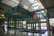
Currently, American Eagle operates one daily flight to Dallas/Fort Worth International Airport on 50-seat ERJ - jets, and five daily (four on weekends) flights to Chicago's O'Hare International Airport on 50 ERJs. Delta Air Lines ceased service to Willard Airport on August 31, 2010. The terminal is made of five gates: gates 1-5
The above content comes from Wikipedia and is published under free licenses – click here to read more.
Location & QuickFacts
Owner & Manager
Airport Operations and Facilities
Airport Communications
Airport Services
Runway InformationRunway 10/28
Radio Navigation Aids
Images and information placed above are from We thank them for the data!
We don't guarantee the information is fresh and accurate. The data may
be wrong or outdated.
|
||||||||||||||||||||||||||||||||||||||||||||||||||||||||||||||||||||||||||||||||||||||||||||||||||||||||||||||||||||||||||||||||||||||||||||||||||||||||||||||||||||||||||||||||||||||||||||||||||||||||||||||||||||||||||||||||||||||||||||||||||||||||||||||||||||||||||||||||||||||||||||||||||||||||||||||||||||||||||||||||||||||||||||||||||||||||||||||||||||||||||

 |
|
Copyright 2004-2026 © by Airports-Worldwide.com, Vyshenskoho st. 36, Lviv 79010, Ukraine Legal Disclaimer |