 |
|
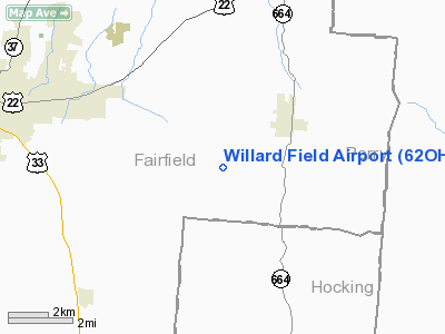
Location & QuickFacts
| FAA Information Effective: | 2008-09-25 |
| Airport Identifier: | 62OH |
| Airport Status: | Operational |
| Longitude/Latitude: | 082-28-00.3000W/39-41-03.8500N
-82.466750/39.684403 (Estimated) |
| Elevation: | 820 ft / 249.94 m (Estimated) |
| Land: | 0 acres |
| From nearest city: | 2 nautical miles W of Bremen, OH |
| Location: | Fairfield County, OH |
| Magnetic Variation: | 07W (2000) |
Owner & Manager
| Ownership: | Privately owned |
| Owner: | Gregory Willard |
| Address: | 6815 Bremen Rd Se
Lancaster, OH 43130 |
| Phone number: | 740-569-7715 |
| Manager: | Gregory Willard |
| Address: | 6815 Bremen Rd Se
Lancaster, OH 43130 |
| Phone number: | 7450-687-6668 |
Airport Operations and Facilities
| Airport Use: | Private |
| Segmented Circle: | No |
| Control Tower: | No |
| Lighting Schedule: | RDO-CTL
ACTVT LIRL RY 18/36 - 123.05. |
| Sectional chart: | Cincinnati |
| Region: | AGL - Great Lakes |
| Boundary ARTCC: | ZID - Indianapolis |
| Tie-in FSS: | DAY - Dayton |
| FSS Toll Free: | 1-800-WX-BRIEF |
Runway Information
Runway 18/36
| Dimension: | 3400 x 60 ft / 1036.3 x 18.3 m |
| Surface: | TURF, |
| Edge Lights: | Low |
| |
Runway 18 |
Runway 36 |
| Traffic Pattern: | Left | Left |
| Obstruction: | | 60 ft trees, 200.0 ft from runway |
|
Radio Navigation Aids
| ID |
Type |
Name |
Ch |
Freq |
Var |
Dist |
| HEH | NDB | Newark | | 524.00 | 06W | 20.5 nm |
| CM | NDB | Sumie | | 391.00 | 05W | 22.5 nm |
| CYO | NDB | Circleville | | 366.00 | 05W | 25.7 nm |
| HRA | NDB | Zanesville | | 204.00 | 06W | 28.6 nm |
| RZT | NDB | Ross County | | 236.00 | 05W | 30.0 nm |
| UGS | NDB | University | | 250.00 | 06W | 30.2 nm |
| CHC | NDB | Grens | | 272.00 | 04W | 32.5 nm |
| BU | NDB | Boutn | | 230.00 | 05W | 35.1 nm |
| DKG | NDB | Don Scott | | 348.00 | 05W | 36.9 nm |
| EOP | NDB | Waverly | | 385.00 | 06W | 37.9 nm |
| OS | NDB | Fuler | | 515.00 | 05W | 41.1 nm |
| CSS | NDB | Court House | | 414.00 | 05W | 43.1 nm |
| DLZ | NDB | Delaware | | 215.00 | 06W | 46.1 nm |
| UYF | NDB | London | | 263.00 | 06W | 48.5 nm |
| LCK | TACAN | Rickenbacker | 069X | | 05W | 22.6 nm |
| XUB | VOR | Yellow Bud | | 112.50 | 05W | 25.5 nm |
| ZZV | VOR/DME | Zanesville | 051X | 111.40 | 06W | 30.7 nm |
| TVT | VOR/DME | Tiverton | 112X | 116.50 | 03W | 49.1 nm |
| APE | VORTAC | Appleton | 114X | 116.70 | 06W | 28.6 nm |
| CMH | VOT | Port Columbus | | 111.00 | | 26.9 nm |
Remarks
- PRVDD CLEAR OBSTACLE FREE ZONE & CLEAR 20:1 APCH.
Images and information placed above are from
http://www.airport-data.com/airport/62OH/
We thank them for the data!
| General Info
|
| Country |
United States
|
| State |
OHIO
|
| FAA ID |
62OH
|
| Latitude |
39-41-03.850N
|
| Longitude |
082-28-00.300W
|
| Elevation |
820 feet
|
| Near City |
BREMEN
|
We don't guarantee the information is fresh and accurate. The data may
be wrong or outdated.
For more up-to-date information please refer to other sources.
|
|


