 |
|
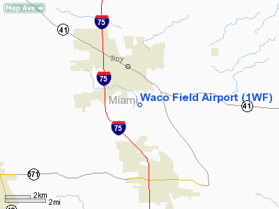
Location & QuickFacts
| FAA Information Effective: | 2008-09-25 |
| Airport Identifier: | 1WF |
| Airport Status: | Operational |
| Longitude/Latitude: | 084-11-53.0000W/40-00-53.1500N
-84.198056/40.014764 (Estimated) |
| Elevation: | 820 ft / 249.94 m (Estimated) |
| Land: | 0 acres |
| From nearest city: | 2 nautical miles S of Troy, OH |
| Location: | Miami County, OH |
| Magnetic Variation: | 05W (1995) |
Owner & Manager
| Ownership: | Privately owned |
| Owner: | Waco Historical Society
RICHARD AMRHEIN, PRESIDENT, 3580 MONROE-CONCORD ROAD, TROY OH 45373. |
| Address: | Box 62
Troy, OH 45373 |
| Phone number: | 937-335-9226 |
| Manager: | Dave Bucher |
| Address: | 105 S Market St
Troy, OH 45373 |
| Phone number: | 937-545-5097 |
Airport Operations and Facilities
| Airport Use: | Open to public |
| Segmented Circle: | No |
| Control Tower: | No |
| Sectional chart: | Detroit |
| Region: | AGL - Great Lakes |
| Boundary ARTCC: | ZID - Indianapolis |
| Tie-in FSS: | DAY - Dayton |
| FSS Toll Free: | 1-800-WX-BRIEF |
| NOTAMs Facility: | DAY (NOTAM-d service avaliable) |
Airport Communications
Runway Information
Runway 18/36
| Dimension: | 2428 x 100 ft / 740.1 x 30.5 m |
| Surface: | TURF, |
| |
Runway 18 |
Runway 36 |
| Traffic Pattern: | Left | Left |
| Displaced threshold: | 600.00 ft | 0.00 ft |
| Obstruction: | 41 ft pline, 258.0 ft from runway, 6:1 slope to clear
RY 18 APCH 20:1 TO DSPLCD THLD. | 10 ft brush, 252.0 ft from runway, 25:1 slope to clear |
|
Radio Navigation Aids
| ID |
Type |
Name |
Ch |
Freq |
Var |
Dist |
| VES | NDB | Versailles | | 356.00 | 04W | 18.8 nm |
| CCJ | NDB | Clark County | | 341.00 | 04W | 21.1 nm |
| XEN | NDB | Xenia | | 395.00 | 03W | 21.8 nm |
| EDJ | NDB | Bellefontaine | | 242.00 | 05W | 27.8 nm |
| CQA | NDB | Lakefield | | 205.00 | 04W | 32.7 nm |
| HKF | NDB | Hook Field | | 239.00 | 04W | 33.1 nm |
| UYF | NDB | London | | 263.00 | 06W | 34.1 nm |
| RUV | NDB | Rushsylvania | | 326.00 | 05W | 36.1 nm |
| IL | NDB | Airbo | | 407.00 | 04W | 38.0 nm |
| OXD | NDB | Oxford | | 282.00 | 04W | 40.7 nm |
| MRT | NDB | Marysville | | 403.00 | 05W | 41.0 nm |
| LYL | NDB | Lima | | 362.00 | 04W | 42.2 nm |
| HAO | NDB | Hamilton | | 260.00 | 04W | 42.3 nm |
| HW | NDB | Cubla | | 299.00 | 04W | 42.5 nm |
| PLD | NDB | Portland | | 257.00 | 03W | 44.7 nm |
| CSS | NDB | Court House | | 414.00 | 05W | 44.8 nm |
| OS | NDB | Fuler | | 515.00 | 05W | 46.1 nm |
| ISZ | NDB | Cincinnati-blue Ash | | 388.00 | 04W | 46.9 nm |
| BU | NDB | Boutn | | 230.00 | 05W | 47.3 nm |
| MDE | NDB | Madeira | | 379.00 | 04W | 48.2 nm |
| FFO | TACAN | Patterson | 099X | | 04W | 13.5 nm |
| XSF | TACAN | Springfield | 065X | | 04W | 19.6 nm |
| AOH | VOR | Allen County | | 108.40 | 04W | 42.9 nm |
| DQN | VOR/DME | Dayton | 092X | 114.50 | 01W | 9.2 nm |
| SGH | VOR/DME | Springfield | 079X | 113.20 | 04W | 19.5 nm |
| MXQ | VOR/DME | Midwest | 076X | 112.90 | 04W | 39.7 nm |
| ROD | VORTAC | Rosewood | 122X | 117.50 | 05W | 17.9 nm |
| RID | VORTAC | Richmond | 043X | 110.60 | 03W | 33.4 nm |
| DAY | VOT | Dayton J M Cox-day | | 111.00 | | 6.9 nm |
Remarks
- 405 FT (AGL) LGTD RADIO ANT 4200 FT NE OF RY 18.
- PRVDD CLEAR 20:1 APCHS, CLEAR OBSTACLE FREE ZONE, AND CLEAR RWYN SAFETY AREA.
Images and information placed above are from
http://www.airport-data.com/airport/1WF/
We thank them for the data!
| General Info
|
| Country |
United States
|
| State |
OHIO
|
| FAA ID |
1WF
|
| Latitude |
40-00-53.150N
|
| Longitude |
084-11-53.000W
|
| Elevation |
820 feet
|
| Near City |
TROY
|
We don't guarantee the information is fresh and accurate. The data may
be wrong or outdated.
For more up-to-date information please refer to other sources.
|
|


