 |
|
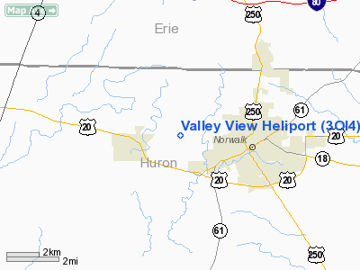
Location & QuickFacts
| FAA Information Effective: | 2008-09-25 |
| Airport Identifier: | 3OI4 |
| Airport Status: | Operational |
| Longitude/Latitude: | 082-39-54.6480W/41-14-59.6910N
-82.665180/41.249914 (Estimated) |
| Elevation: | 700 ft / 213.36 m (Estimated) |
| Land: | 0 acres |
| From nearest city: | 1 nautical miles W of Norwalk, OH |
| Location: | Huron County, OH |
| Magnetic Variation: | 06W (1985) |
Owner & Manager
| Ownership: | Privately owned |
| Owner: | James P. Smith |
| Address: | 2045 Washington Rd
Nowalk, OH 44857 |
| Phone number: | 419-668-0409 |
| Manager: | James P. Smith |
| Address: | 2045 Washington Rd
Norwalk, OH 44857 |
| Phone number: | 419-668-0409 |
Airport Operations and Facilities
| Airport Use: | Private |
| Wind indicator: | Yes |
| Segmented Circle: | No |
| Control Tower: | No |
| Landing fee charge: | No |
| Sectional chart: | Detroit |
| Region: | AGL - Great Lakes |
| Boundary ARTCC: | ZOB - Cleveland |
| Tie-in FSS: | CLE - Cleveland |
| FSS on Airport: | No |
| FSS Toll Free: | 1-800-WX-BRIEF |
Runway Information
Helipad H1
| Dimension: | 120 x 70 ft / 36.6 x 21.3 m |
| Surface: | GRAVEL, |
| |
Runway H1 |
Runway |
| Traffic Pattern: | Left | Left |
|
Radio Navigation Aids
| ID |
Type |
Name |
Ch |
Freq |
Var |
Dist |
| PCW | NDB | Port Clinton | | 423.00 | 06W | 18.6 nm |
| AAU | NDB | Ashland | | 329.00 | 07W | 25.4 nm |
| TII | NDB | Tiffin | | 269.00 | 05W | 26.2 nm |
| MF | NDB | Manns | | 372.00 | 06W | 30.7 nm |
| PT | NDB | Pelee Island | | 283.00 | 05W | 31.8 nm |
| CL | NDB | Harri | | 344.00 | 07W | 32.1 nm |
| FZI | NDB | Fostoria | | 379.00 | 05W | 33.3 nm |
| MNN | NDB | Marion | | 201.00 | 05W | 42.2 nm |
| EZE | NDB | Engel | | 226.00 | 07W | 44.9 nm |
| BNR | NDB | Benton Ridge | | 334.00 | 05W | 47.5 nm |
| BKL | NDB | Burke Lakefront | | 416.00 | 07W | 48.2 nm |
| BUD | VOR | Buckeye | | 109.80 | 05W | 42.2 nm |
| MAH | VOR | Marathon | | 114.90 | 05W | 47.4 nm |
| SKY | VOR/DME | Sandusky | 029X | 109.20 | 04W | 11.1 nm |
| DJB | VOR/DME | Dryer | 083X | 113.60 | 05W | 23.6 nm |
| VWV | VOR/DME | Waterville | 078X | 113.10 | 02W | 45.6 nm |
| MFD | VORTAC | Mansfield | 025X | 108.80 | 03W | 23.2 nm |
| CLE | VOT | Cleveland | | 110.40 | | 38.1 nm |
Remarks
- APCH/DEP RTE HEL OPNS CONDUCTED 90-120 DEG CLKWS USING TCH PAD AS CNTR COMPASS ROSE. OPNS ARE RSTRD TP MAX 10 KNOT TLWD CMPT; TKOF/LNDG ARE APROPLY MKD; NON-OBSTRUCTG WIND INDCR MAINTD ADJ TO TKOF/LNDG AREA.
Images and information placed above are from
http://www.airport-data.com/airport/3OI4/
We thank them for the data!
| General Info
|
| Country |
United States
|
| State |
OHIO
|
| FAA ID |
3OI4
|
| Latitude |
41-14-59.691N
|
| Longitude |
082-39-54.648W
|
| Elevation |
700 feet
|
| Near City |
NORWALK
|
We don't guarantee the information is fresh and accurate. The data may
be wrong or outdated.
For more up-to-date information please refer to other sources.
|
|


