 |
|
Location & QuickFacts
| FAA Information Effective: | 2008-09-25 |
| Airport Identifier: | 13OI |
| Airport Status: | Operational |
| Longitude/Latitude: | 081-27-17.4160W/40-30-54.2310N
-81.454838/40.515064 (Estimated) |
| Elevation: | 926 ft / 282.24 m (Estimated) |
| Land: | 0 acres |
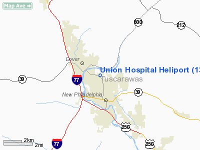
| From nearest city: | 0 nautical miles N of Dover, OH |
| Location: | Tuscarawas County, OH |
| Magnetic Variation: | 06W (1985) |
Owner & Manager
| Ownership: | Privately owned |
| Owner: | Union Hospital Assoc |
| Address: | 659 Boulevard
Dover, OH 44622 |
| Phone number: | 216-343-3311 |
| Manager: | Union Hospital Assoc |
| Address: | 659 Boulevard
Dover, OH 44622 |
| Phone number: | 216-343-3311 |
Airport Operations and Facilities
| Airport Use: | Private
MEDICAL USE. |
| Wind indicator: | Yes |
| Segmented Circle: | No |
| Control Tower: | No |
| Landing fee charge: | No |
| Sectional chart: | Detroit |
| Region: | AGL - Great Lakes |
| Boundary ARTCC: | ZOB - Cleveland |
| Tie-in FSS: | CLE - Cleveland |
| FSS on Airport: | No |
| FSS Toll Free: | 1-800-WX-BRIEF |
Runway Information
Helipad H1
| Dimension: | 25 x 25 ft / 7.6 x 7.6 m |
| Surface: | TURF, |
| |
Runway H1 |
Runway |
| Traffic Pattern: | Left | Left |
|
Radio Navigation Aids
| ID |
Type |
Name |
Ch |
Freq |
Var |
Dist |
| TSO | NDB | Tolson | | 395.00 | 07W | 17.5 nm |
| MLR | NDB | Millersburg/dcmsnd | | 382.00 | 06W | 19.2 nm |
| CFX | NDB | Cadiz | | 239.00 | 07W | 26.2 nm |
| AK | NDB | Akron | | 362.00 | 07W | 33.5 nm |
| HRA | NDB | Zanesville | | 204.00 | 06W | 42.3 nm |
| AAU | NDB | Ashland | | 329.00 | 07W | 45.3 nm |
| MF | NDB | Manns | | 372.00 | 06W | 47.6 nm |
| BSV | VOR/DME | Briggs | 071X | 112.40 | 04W | 13.6 nm |
| CTW | VOR/DME | Newcomerstown | 055X | 111.80 | 07W | 17.2 nm |
| TVT | VOR/DME | Tiverton | 112X | 116.50 | 03W | 30.9 nm |
| ACO | VOR/DME | Akron | 091X | 114.40 | 04W | 37.5 nm |
| ZZV | VOR/DME | Zanesville | 051X | 111.40 | 06W | 39.9 nm |
| AIR | VOR/DME | Bellaire | 118X | 117.10 | 07W | 41.8 nm |
| HLG | VOR/DME | Wheeling | 059X | 112.20 | 07W | 43.4 nm |
| CAK | VOT | Akron/canton Regional | | 110.60 | | 24.1 nm |
Remarks
- PRVDD ALL INGRESS/EGRESS OPNS CONDUCTED IN AREA FROM 150-210 DEGS CLKWS & FROM 300-360 DEGS FROM LNDG PAD USING PAD AS CNTR OF COMPASS ROSE.
Images and information placed above are from
http://www.airport-data.com/airport/13OI/
We thank them for the data!
| General Info
|
| Country |
United States
|
| State |
OHIO
|
| FAA ID |
13OI
|
| Latitude |
40-30-54.231N
|
| Longitude |
081-27-17.416W
|
| Elevation |
926 feet
|
| Near City |
DOVER
|
We don't guarantee the information is fresh and accurate. The data may
be wrong or outdated.
For more up-to-date information please refer to other sources.
|
|


