 |
|
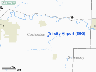
Location & QuickFacts
| FAA Information Effective: | 2008-09-25 |
| Airport Identifier: | 80G |
| Airport Status: | Operational |
| Longitude/Latitude: | 081-44-09.4520W/40-14-52.2570N
-81.735959/40.247849 (Estimated) |
| Elevation: | 844 ft / 257.25 m (Surveyed) |
| Land: | 10 acres |
| From nearest city: | 2 nautical miles SE of West Lafayette, OH |
| Location: | Coshocton County, OH |
| Magnetic Variation: | 06W (1985) |
Owner & Manager
| Ownership: | Privately owned |
| Owner: | Clyde R. Zimmer |
| Address: | 108 W Russell Ave
West Lafayette, OH 43845 |
| Phone number: | 614-545-7309 |
| Manager: | C. R. Zimmer |
| Address: | 108 W Russell Ave
West Lafayette, OH 43845 |
| Phone number: | 614-545-7309 |
Airport Operations and Facilities
| Airport Use: | Open to public |
| Wind indicator: | Yes |
| Segmented Circle: | No |
| Control Tower: | No |
| Lighting Schedule: | PHONE REQ
FOR LIRL 10/28 CALL 614-545-7309/7580/9135. |
| Landing fee charge: | No |
| Sectional chart: | Detroit |
| Region: | AGL - Great Lakes |
| Boundary ARTCC: | ZID - Indianapolis |
| Tie-in FSS: | CLE - Cleveland |
| FSS on Airport: | No |
| FSS Toll Free: | 1-800-WX-BRIEF |
| NOTAMs Facility: | CLE (NOTAM-d service avaliable) |
Airport Communications
Airport Services
Runway Information
Runway 10/28
| Dimension: | 3000 x 100 ft / 914.4 x 30.5 m
140 FT GRASS STWY ON EAST END. |
| Surface: | TURF, Good Condition |
| Edge Lights: | Non-standard lighting system
FIRST 453 FT NOT LIGHTED ON RY 10. NSTD LIRL FOR LCL USE ONLY. |
| |
Runway 10 |
Runway 28 |
| Longitude: | 081-44-25.1800W | 081-43-53.7100W |
| Latitude: | 40-14-49.5700N | 40-14-54.9200N |
| Elevation: | 844.00 ft | 844.00 ft |
| Alignment: | 77 | 127 |
| Traffic Pattern: | Left | Right |
| Displaced threshold: | 453.00 ft | 0.00 ft |
| Runway End Identifier: | No | No |
| Centerline Lights: | No | No |
| Touchdown Lights: | No | No |
| Obstruction: | 25 ft pline | 44 ft pline, 476.0 ft from runway, 102 ft right of centerline, 10:1 slope to clear |
|
Radio Navigation Aids
| ID |
Type |
Name |
Ch |
Freq |
Var |
Dist |
| MLR | NDB | Millersburg/dcmsnd | | 382.00 | 06W | 18.7 nm |
| HRA | NDB | Zanesville | | 204.00 | 06W | 22.2 nm |
| CFX | NDB | Cadiz | | 239.00 | 07W | 33.2 nm |
| TSO | NDB | Tolson | | 395.00 | 07W | 35.6 nm |
| HEH | NDB | Newark | | 524.00 | 06W | 36.0 nm |
| MF | NDB | Manns | | 372.00 | 06W | 44.9 nm |
| AAU | NDB | Ashland | | 329.00 | 07W | 49.1 nm |
| CM | NDB | Sumie | | 391.00 | 05W | 49.4 nm |
| CTW | VOR/DME | Newcomerstown | 055X | 111.80 | 07W | 12.0 nm |
| ZZV | VOR/DME | Zanesville | 051X | 111.40 | 06W | 19.8 nm |
| TVT | VOR/DME | Tiverton | 112X | 116.50 | 03W | 21.9 nm |
| BSV | VOR/DME | Briggs | 071X | 112.40 | 04W | 32.7 nm |
| AIR | VOR/DME | Bellaire | 118X | 117.10 | 07W | 44.4 nm |
| APE | VORTAC | Appleton | 114X | 116.70 | 06W | 39.6 nm |
| CAK | VOT | Akron/canton Regional | | 110.60 | | 42.4 nm |
Remarks
- RY 10 ADDITONAL OBSTN +300 FT WOODED HILL 2700 FT FR THLD.
- DUE TO INCOMPATIBILITY OF ARPT TFC PAT ASP AREAS ASSOCD WITH THIS ARPT & PORTEUS ARPT.
Images and information placed above are from
http://www.airport-data.com/airport/80G/
We thank them for the data!
| General Info
|
| Country |
United States
|
| State |
OHIO
|
| FAA ID |
3G6
|
| Latitude |
40-54-21.600N
|
| Longitude |
081-00-00.100W
|
| Elevation |
1188 feet
|
| Near City |
SEBRING
|
We don't guarantee the information is fresh and accurate. The data may
be wrong or outdated.
For more up-to-date information please refer to other sources.
|
|


