 |
|
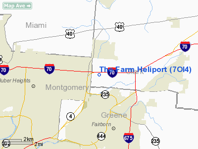
Location & QuickFacts
| FAA Information Effective: | 2008-09-25 |
| Airport Identifier: | 7OI4 |
| Airport Status: | Operational |
| Longitude/Latitude: | 084-02-29.7680W/39-51-45.2110N
-84.041602/39.862559 (Estimated) |
| Elevation: | 835 ft / 254.51 m (Estimated) |
| Land: | 0 acres |
| From nearest city: | 3 nautical miles NW of Fairborn, OH |
| Location: | Clark County, OH |
| Magnetic Variation: | 04W (1985) |
Owner & Manager
| Ownership: | Privately owned |
| Owner: | Hilty Farm Supply |
| Address: | 12026 Lower Valley Pk
Medway, OH 45341 |
| Phone number: | 513-878-7643 |
| Manager: | Paul Hilty |
| Address: | 9055 Adams Rd
Dayton, OH 45424 |
| Phone number: | 513-233-1617 |
Airport Operations and Facilities
| Airport Use: | Private |
| Wind indicator: | Yes |
| Segmented Circle: | No |
| Control Tower: | No |
| Landing fee charge: | No |
| Sectional chart: | Cincinnati |
| Region: | AGL - Great Lakes |
| Boundary ARTCC: | ZID - Indianapolis |
| Tie-in FSS: | DAY - Dayton |
| FSS Toll Free: | 1-800-WX-BRIEF |
Runway Information
Helipad H1
| Dimension: | 10 x 10 ft / 3.0 x 3.0 m |
| Surface: | MATS,
WOOD PLATFORM. |
| |
Runway H1 |
Runway |
| Traffic Pattern: | Left | Left |
|
Radio Navigation Aids
| ID |
Type |
Name |
Ch |
Freq |
Var |
Dist |
| XEN | NDB | Xenia | | 395.00 | 03W | 10.2 nm |
| CCJ | NDB | Clark County | | 341.00 | 04W | 12.1 nm |
| IL | NDB | Airbo | | 407.00 | 04W | 26.4 nm |
| UYF | NDB | London | | 263.00 | 06W | 26.9 nm |
| HKF | NDB | Hook Field | | 239.00 | 04W | 28.8 nm |
| VES | NDB | Versailles | | 356.00 | 04W | 30.3 nm |
| HW | NDB | Cubla | | 299.00 | 04W | 31.5 nm |
| EDJ | NDB | Bellefontaine | | 242.00 | 05W | 32.3 nm |
| CSS | NDB | Court House | | 414.00 | 05W | 33.9 nm |
| HAO | NDB | Hamilton | | 260.00 | 04W | 38.3 nm |
| MRT | NDB | Marysville | | 403.00 | 05W | 38.6 nm |
| BU | NDB | Boutn | | 230.00 | 05W | 38.7 nm |
| RUV | NDB | Rushsylvania | | 326.00 | 05W | 39.7 nm |
| ISZ | NDB | Cincinnati-blue Ash | | 388.00 | 04W | 40.3 nm |
| OXD | NDB | Oxford | | 282.00 | 04W | 40.3 nm |
| OS | NDB | Fuler | | 515.00 | 05W | 40.9 nm |
| MDE | NDB | Madeira | | 379.00 | 04W | 41.1 nm |
| CQA | NDB | Lakefield | | 205.00 | 04W | 44.3 nm |
| LUK | NDB | Cincinnati | | 335.00 | 04W | 44.5 nm |
| DKG | NDB | Don Scott | | 348.00 | 05W | 46.2 nm |
| HOC | NDB | Hillsboro | | 278.00 | 05W | 46.8 nm |
| CHC | NDB | Grens | | 272.00 | 04W | 47.5 nm |
| PWF | NDB | Sportys | | 245.00 | 04W | 47.9 nm |
| DLZ | NDB | Delaware | | 215.00 | 06W | 49.8 nm |
| FFO | TACAN | Patterson | 099X | | 04W | 2.7 nm |
| XSF | TACAN | Springfield | 065X | | 04W | 9.4 nm |
| SGH | VOR/DME | Springfield | 079X | 113.20 | 04W | 9.2 nm |
| DQN | VOR/DME | Dayton | 092X | 114.50 | 01W | 18.8 nm |
| MXQ | VOR/DME | Midwest | 076X | 112.90 | 04W | 28.3 nm |
| ROD | VORTAC | Rosewood | 122X | 117.50 | 05W | 25.6 nm |
| RID | VORTAC | Richmond | 043X | 110.60 | 03W | 37.4 nm |
| DAY | VOT | Dayton J M Cox-day | | 111.00 | | 8.6 nm |
| LUK | VOT | Cincinnati Muni/lunken | | 108.40 | | 47.8 nm |
Remarks
- ALL APP/DEP OPRNS CONDUCTED IN AREA FROM 360 DEG TO 90 DEG AND FROM 170 DEG CLOCKWISE TO 190 DEG; AREA APPRO MARKED; WIND INDICATOR MAINTAINED.
Images and information placed above are from
http://www.airport-data.com/airport/7OI4/
We thank them for the data!
| General Info
|
| Country |
United States
|
| State |
OHIO
|
| FAA ID |
7OI4
|
| Latitude |
39-51-45.211N
|
| Longitude |
084-02-29.768W
|
| Elevation |
835 feet
|
| Near City |
FAIRBORN
|
We don't guarantee the information is fresh and accurate. The data may
be wrong or outdated.
For more up-to-date information please refer to other sources.
|
|


