 |
|
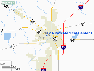
St Rita's Medical Center Heliport |
Location & QuickFacts
| FAA Information Effective: | 2008-09-25 |
| Airport Identifier: | 94OH |
| Airport Status: | Operational |
| Longitude/Latitude: | 084-07-17.8130W/40-44-22.1830N
-84.121615/40.739495 (Estimated) |
| Elevation: | 862 ft / 262.74 m (Estimated) |
| Land: | 0 acres |
| From nearest city: | 0 nautical miles N of Lima, OH |
| Location: | Allen County, OH |
| Magnetic Variation: | 05W (2000) |
Owner & Manager
| Ownership: | Privately owned |
| Owner: | Saint Rita's Medical Center |
| Address: | 730 W Market St
Lima, OH 45801 |
| Phone number: | 419-226-9116 |
| Manager: | R.l. Sanders |
| Address: | 730 W Market St
Lima, OH 45801 |
Airport Operations and Facilities
| Airport Use: | Private
MEDICAL USE. |
| Wind indicator: | Yes |
| Segmented Circle: | No |
| Control Tower: | No |
| Lighting Schedule: | PHONE REQ
FOR BEACON LGT PHONE 419-226-9116. |
| Beacon Color: | Clear-Green-Yellow (heliport) |
| Sectional chart: | Detroit |
| Region: | AGL - Great Lakes |
| Boundary ARTCC: | ZID - Indianapolis |
| Tie-in FSS: | DAY - Dayton |
| FSS Toll Free: | 1-800-WX-BRIEF |
Runway Information
Helipad H1
| Dimension: | 40 x 40 ft / 12.2 x 12.2 m |
| Surface: | ASPH, |
| |
Runway H1 |
Runway |
| Traffic Pattern: | Left | Left |
|
Radio Navigation Aids
| ID |
Type |
Name |
Ch |
Freq |
Var |
Dist |
| LYL | NDB | Lima | | 362.00 | 04W | 4.9 nm |
| PDR | NDB | Ottawa | | 233.00 | 05W | 18.8 nm |
| VFU | NDB | Stanley | | 411.00 | 05W | 23.6 nm |
| CQA | NDB | Lakefield | | 205.00 | 04W | 25.5 nm |
| EDJ | NDB | Bellefontaine | | 242.00 | 05W | 26.2 nm |
| BNR | NDB | Benton Ridge | | 334.00 | 05W | 26.6 nm |
| RUV | NDB | Rushsylvania | | 326.00 | 05W | 26.7 nm |
| VES | NDB | Versailles | | 356.00 | 04W | 36.9 nm |
| DFI | NDB | Defiance | | 246.00 | 05W | 38.3 nm |
| FZI | NDB | Fostoria | | 379.00 | 05W | 42.6 nm |
| PLD | NDB | Portland | | 257.00 | 03W | 42.9 nm |
| TII | NDB | Tiffin | | 269.00 | 05W | 46.8 nm |
| MRT | NDB | Marysville | | 403.00 | 05W | 46.9 nm |
| BYN | NDB | Bryan | | 260.00 | 04W | 47.2 nm |
| MNN | NDB | Marion | | 201.00 | 05W | 48.5 nm |
| AOH | VOR | Allen County | | 108.40 | 04W | 7.3 nm |
| MAH | VOR | Marathon | | 114.90 | 05W | 26.6 nm |
| BUD | VOR | Buckeye | | 109.80 | 05W | 48.8 nm |
| DQN | VOR/DME | Dayton | 092X | 114.50 | 01W | 45.3 nm |
| VWV | VOR/DME | Waterville | 078X | 113.10 | 02W | 48.1 nm |
| FDY | VORTAC | Findlay | 019X | 108.20 | 02W | 21.1 nm |
| ROD | VORTAC | Rosewood | 122X | 117.50 | 05W | 27.4 nm |
Remarks
- OPNS FM 50 DEG TO 90 DEG AND FM 250 DEG TO 270 DEG; AREA IS MARKED; WIND INDICATOR IS MAINT.
Images and information placed above are from
http://www.airport-data.com/airport/94OH/
We thank them for the data!
| General Info
|
| Country |
United States
|
| State |
OHIO
|
| FAA ID |
94OH
|
| Latitude |
40-44-22.183N
|
| Longitude |
084-07-17.813W
|
| Elevation |
862 feet
|
| Near City |
LIMA
|
We don't guarantee the information is fresh and accurate. The data may
be wrong or outdated.
For more up-to-date information please refer to other sources.
|
|


