 |
|
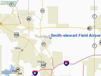
Smith-stewart Field Airport |
Location & QuickFacts
| FAA Information Effective: | 2008-09-25 |
| Airport Identifier: | 79OH |
| Airport Status: | Operational |
| Longitude/Latitude: | 080-40-59.2770W/41-12-35.2050N
-80.683132/41.209779 (Estimated) |
| Elevation: | 1092 ft / 332.84 m (Surveyed) |
| Land: | 80 acres |
| From nearest city: | 2 nautical miles SW of Vienna, OH |
| Location: | Trumbull County, OH |
| Magnetic Variation: | 07W (1985) |
Owner & Manager
| Ownership: | Privately owned |
| Owner: | Paul Price |
| Address: | 3842 Smith-stewart Rd
Niles, OH 44446 |
| Manager: | James P. Strock |
| Address: | 3856 Smith-stewart Rd
Niles, OH 44446 |
| Phone number: | 216-539-6137 |
Airport Operations and Facilities
| Airport Use: | Private |
| Wind indicator: | Yes |
| Segmented Circle: | No |
| Control Tower: | No |
| Landing fee charge: | No |
| Sectional chart: | Detroit |
| Region: | AGL - Great Lakes |
| Boundary ARTCC: | ZOB - Cleveland |
| Tie-in FSS: | CLE - Cleveland |
| FSS on Airport: | No |
| FSS Toll Free: | 1-800-WX-BRIEF |
Airport Services
| Airframe Repair: | NONE |
| Power Plant Repair: | NONE |
Runway Information
Runway 18/36
| Dimension: | 1800 x 100 ft / 548.6 x 30.5 m |
| Surface: | TURF, |
| |
Runway 18 |
Runway 36 |
| Traffic Pattern: | Left | Left |
| Displaced threshold: | 1000.00 ft | 0.00 ft |
| Obstruction: | 30 ft trees | 30 ft trees, 700.0 ft from runway |
|
Radio Navigation Aids
| ID |
Type |
Name |
Ch |
Freq |
Var |
Dist |
| HBD | NDB | Hubbard | | 408.00 | 08W | 7.7 nm |
| UCP | NDB | Castle | | 272.00 | 09W | 16.5 nm |
| AK | NDB | Akron | | 362.00 | 07W | 33.0 nm |
| LQL | NDB | Lakeland | | 263.00 | 08W | 42.3 nm |
| TSO | NDB | Tolson | | 395.00 | 07W | 42.8 nm |
| BKL | NDB | Burke Lakefront | | 416.00 | 07W | 48.2 nm |
| EZE | NDB | Engel | | 226.00 | 07W | 49.8 nm |
| FKL | VOR | Franklin | | 109.60 | 06W | 39.8 nm |
| ACO | VOR/DME | Akron | 091X | 114.40 | 04W | 24.2 nm |
| CXR | VOR/DME | Chardon | 074X | 112.70 | 05W | 28.5 nm |
| JFN | VOR/DME | Jefferson | 099X | 115.20 | 05W | 33.2 nm |
| LNN | VOR/DME | Lost Nation | 039X | 110.20 | 08W | 42.7 nm |
| BSV | VOR/DME | Briggs | 071X | 112.40 | 04W | 44.2 nm |
| YNG | VORTAC | Youngstown | 027X | 109.00 | 05W | 7.3 nm |
| EWC | VORTAC | Ellwood City | 105X | 115.80 | 08W | 31.5 nm |
| MMJ | VORTAC | Montour | 057X | 112.00 | 08W | 48.7 nm |
| CAK | VOT | Akron/canton Regional | | 110.60 | | 38.7 nm |
Remarks
- RWY SOFT WHEN WET.
- VFR ONLY
Images and information placed above are from
http://www.airport-data.com/airport/79OH/
We thank them for the data!
| General Info
|
| Country |
United States
|
| State |
OHIO
|
| FAA ID |
79OH
|
| Latitude |
41-12-35.205N
|
| Longitude |
080-40-59.277W
|
| Elevation |
1092 feet
|
| Near City |
VIENNA
|
We don't guarantee the information is fresh and accurate. The data may
be wrong or outdated.
For more up-to-date information please refer to other sources.
|
|


