 |
|
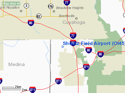
Location & QuickFacts
| FAA Information Effective: | 2008-09-25 |
| Airport Identifier: | OI45 |
| Airport Status: | Operational |
| Longitude/Latitude: | 081-39-31.4480W/41-15-54.1960N
-81.658736/41.265054 (Estimated) |
| Elevation: | 1250 ft / 381.00 m (Estimated) |
| Land: | 0 acres |
| From nearest city: | 2 nautical miles N of Richfield, OH |
| Location: | Summit County, OH |
| Magnetic Variation: | 07W (1985) |
Owner & Manager
| Ownership: | Privately owned |
| Owner: | Edward Haslem |
| Address: | 4915 Alger Road
Richfield, OH 44286 |
| Phone number: | 216-659-6524 |
| Manager: | Edward Haslem |
| Address: | 4915 Alger Road
Richfield, OH 44286 |
| Phone number: | 216-659-6524 |
Airport Operations and Facilities
| Airport Use: | Private
PERSONAL USE. |
| Wind indicator: | Yes |
| Segmented Circle: | No |
| Control Tower: | No |
| Landing fee charge: | No |
| Sectional chart: | Detroit |
| Region: | AGL - Great Lakes |
| Boundary ARTCC: | ZOB - Cleveland |
| Tie-in FSS: | CLE - Cleveland |
| FSS on Airport: | No |
| FSS Toll Free: | 1-800-WX-BRIEF |
Runway Information
Runway 10/28
| Dimension: | 2200 x 100 ft / 670.6 x 30.5 m |
| Surface: | TURF, |
| |
Runway 10 |
Runway 28 |
| Traffic Pattern: | Left | Left |
|
Radio Navigation Aids
| ID |
Type |
Name |
Ch |
Freq |
Var |
Dist |
| EZE | NDB | Engel | | 226.00 | 07W | 13.8 nm |
| CL | NDB | Harri | | 344.00 | 07W | 14.5 nm |
| BKL | NDB | Burke Lakefront | | 416.00 | 07W | 15.9 nm |
| AK | NDB | Akron | | 362.00 | 07W | 17.0 nm |
| LQL | NDB | Lakeland | | 263.00 | 08W | 28.1 nm |
| AAU | NDB | Ashland | | 329.00 | 07W | 32.5 nm |
| MLR | NDB | Millersburg/dcmsnd | | 382.00 | 06W | 44.6 nm |
| MF | NDB | Manns | | 372.00 | 06W | 46.6 nm |
| TSO | NDB | Tolson | | 395.00 | 07W | 49.8 nm |
| ACO | VOR/DME | Akron | 091X | 114.40 | 04W | 22.7 nm |
| DJB | VOR/DME | Dryer | 083X | 113.60 | 05W | 23.4 nm |
| CXR | VOR/DME | Chardon | 074X | 112.70 | 05W | 27.0 nm |
| LNN | VOR/DME | Lost Nation | 039X | 110.20 | 08W | 28.0 nm |
| BSV | VOR/DME | Briggs | 071X | 112.40 | 04W | 33.2 nm |
| SKY | VOR/DME | Sandusky | 029X | 109.20 | 04W | 46.1 nm |
| YNG | VORTAC | Youngstown | 027X | 109.00 | 05W | 44.6 nm |
| MFD | VORTAC | Mansfield | 025X | 108.80 | 03W | 48.5 nm |
| CLE | VOT | Cleveland | | 110.40 | | 12.2 nm |
| CAK | VOT | Akron/canton Regional | | 110.60 | | 23.1 nm |
Images and information placed above are from
http://www.airport-data.com/airport/OI45/
We thank them for the data!
| General Info
|
| Country |
United States
|
| State |
OHIO
|
| FAA ID |
OI45
|
| Latitude |
41-15-54.196N
|
| Longitude |
081-39-31.448W
|
| Elevation |
1250 feet
|
| Near City |
RICHFIELD
|
We don't guarantee the information is fresh and accurate. The data may
be wrong or outdated.
For more up-to-date information please refer to other sources.
|
|


