 |
|
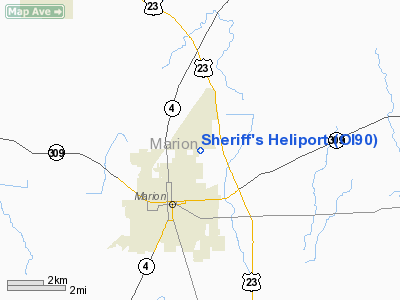
Location & QuickFacts
| FAA Information Effective: | 2008-09-25 |
| Airport Identifier: | OI90 |
| Airport Status: | Operational |
| Longitude/Latitude: | 083-06-30.6850W/40-36-51.2110N
-83.108524/40.614225 (Estimated) |
| Elevation: | 991 ft / 302.06 m (Estimated) |
| Land: | 0 acres |
| From nearest city: | 2 nautical miles NE of Marion, OH |
| Location: | Marion County, OH |
| Magnetic Variation: | 05W (1985) |
Owner & Manager
| Ownership: | Publicly owned |
| Owner: | Marion Co Sheriff's Office |
| Address: | 889 Marion-williams Port Rd E
Marion, OH 43302 |
| Phone number: | 614-382-8244 |
| Manager: | John Creeden |
| Address: | 5707 Wildcat Pike
Marion, OH 43002 |
| Phone number: | 614-499-2344 |
Airport Operations and Facilities
| Airport Use: | Private |
| Wind indicator: | Yes |
| Segmented Circle: | No |
| Control Tower: | No |
| Lighting Schedule: | DUSK-DAWN |
| Beacon Color: | Clear-Yellow (lighted seaplan base) |
| Landing fee charge: | No |
| Sectional chart: | Detroit |
| Region: | AGL - Great Lakes |
| Boundary ARTCC: | ZOB - Cleveland |
| Tie-in FSS: | CLE - Cleveland |
| FSS on Airport: | No |
| FSS Toll Free: | 1-800-WX-BRIEF |
Airport Services
Runway Information
Helipad H1
| Dimension: | 40 x 40 ft / 12.2 x 12.2 m |
| Surface: | CONC,
PAINTED. |
| |
Runway H1 |
Runway |
| Traffic Pattern: | Left | Left |
|
Radio Navigation Aids
| ID |
Type |
Name |
Ch |
Freq |
Var |
Dist |
| MNN | NDB | Marion | | 201.00 | 05W | 1.8 nm |
| DLZ | NDB | Delaware | | 215.00 | 06W | 20.3 nm |
| MRT | NDB | Marysville | | 403.00 | 05W | 25.8 nm |
| RUV | NDB | Rushsylvania | | 326.00 | 05W | 27.2 nm |
| TII | NDB | Tiffin | | 269.00 | 05W | 29.4 nm |
| MF | NDB | Manns | | 372.00 | 06W | 31.6 nm |
| DKG | NDB | Don Scott | | 348.00 | 05W | 32.1 nm |
| OS | NDB | Fuler | | 515.00 | 05W | 32.7 nm |
| BNR | NDB | Benton Ridge | | 334.00 | 05W | 35.3 nm |
| EDJ | NDB | Bellefontaine | | 242.00 | 05W | 35.4 nm |
| CHC | NDB | Grens | | 272.00 | 04W | 36.5 nm |
| FZI | NDB | Fostoria | | 379.00 | 05W | 36.9 nm |
| CM | NDB | Sumie | | 391.00 | 05W | 41.1 nm |
| LYL | NDB | Lima | | 362.00 | 04W | 42.1 nm |
| UYF | NDB | London | | 263.00 | 06W | 44.0 nm |
| AAU | NDB | Ashland | | 329.00 | 07W | 44.2 nm |
| HEH | NDB | Newark | | 524.00 | 06W | 46.1 nm |
| PDR | NDB | Ottawa | | 233.00 | 05W | 46.7 nm |
| BU | NDB | Boutn | | 230.00 | 05W | 48.0 nm |
| LCK | TACAN | Rickenbacker | 069X | | 05W | 49.1 nm |
| BUD | VOR | Buckeye | | 109.80 | 05W | 2.0 nm |
| MAH | VOR | Marathon | | 114.90 | 05W | 34.9 nm |
| AOH | VOR | Allen County | | 108.40 | 04W | 39.6 nm |
| TVT | VOR/DME | Tiverton | 112X | 116.50 | 03W | 45.8 nm |
| MFD | VORTAC | Mansfield | 025X | 108.80 | 03W | 28.1 nm |
| FDY | VORTAC | Findlay | 019X | 108.20 | 02W | 35.9 nm |
| APE | VORTAC | Appleton | 114X | 116.70 | 06W | 36.6 nm |
| ROD | VORTAC | Rosewood | 122X | 117.50 | 05W | 47.0 nm |
| CMH | VOT | Port Columbus | | 111.00 | | 38.6 nm |
Remarks
- E111: PRVDD INGRESS/EGRESS OPNS ARE CONDUCTED ONLY FROM 120-070 DEGS CLKWS FROM THE HELI USING THE PAD AS THE CENTER OF A COMPASS ROSE.
Images and information placed above are from
http://www.airport-data.com/airport/OI90/
We thank them for the data!
| General Info
|
| Country |
United States
|
| State |
OHIO
|
| FAA ID |
OI90
|
| Latitude |
40-36-51.211N
|
| Longitude |
083-06-30.685W
|
| Elevation |
991 feet
|
| Near City |
MARION
|
We don't guarantee the information is fresh and accurate. The data may
be wrong or outdated.
For more up-to-date information please refer to other sources.
|
|


