 |
|
Sandusky County Rgnl Airport |
| Sandusky County Regional Airport |
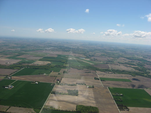 |
| Aerial view of Sandusky County Regional Airport and the surrounding countryside. |
| IATA: none – ICAO: none – FAA LID: S24 |
| Summary |
| Airport type |
Public |
| Owner |
Sandusky County |
| Serves |
Sandusky County |
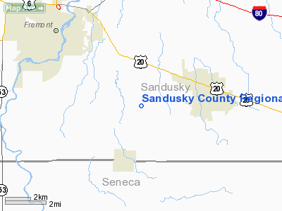
| Location |
Fremont, Ohio |
| Elevation AMSL |
665 ft / 203 m |
| Coordinates |
41°17′45″N 083°02′14″W / 41.29583°N 83.03722°W / 41.29583; -83.03722 |
| Website |
www.flys24.com |
| Runways |
| Direction |
Length |
Surface |
| ft |
m |
| 6/24 |
5,500 |
1,676 |
Asphalt |
| Statistics (2008) |
| Aircraft operations |
5,390 |
| Based aircraft |
16 |
| Source: Federal Aviation Administration |
Sandusky County Regional Airport (FAA LID: S24) is a county-owned public-use airport located five nautical miles (9 km) southeast of the central business district of Fremont, a city in Sandusky County, Ohio, United States.
Facilities and aircraft
Sandusky County Regional Airport has one runway designated 6/24 with a 5,500 by 100 ft (1,676 x 30 m) asphalt pavement. For the 12-month period ending May 31, 2008, the airport had 5,390 aircraft operations, an average of 14 per day: 79% general aviation, 20% air taxi and <1% military. At that time there were 16 aircraft based at this airport: 69% single-engine, 25% multi-engine and 6% helicopter.
The above content comes from Wikipedia and is published under free licenses – click here to read more.
Location & QuickFacts
| FAA Information Effective: | 2008-09-25 |
| Airport Identifier: | S24 |
| Airport Status: | Operational |
| Longitude/Latitude: | 083-02-14.0300W/41-17-44.5400N
-83.037231/41.295706 (Estimated) |
| Elevation: | 665 ft / 202.69 m (Surveyed) |
| Land: | 0 acres |
| From nearest city: | 5 nautical miles SE of Fremont, OH |
| Location: | Sandusky County, OH |
| Magnetic Variation: | 07W (2000) |
Owner & Manager
| Ownership: | Publicly owned |
| Owner: | Sandusky County |
| Address: | 101 S. Front St
Fremont, OH 43420 |
| Phone number: | 419-332-2882 |
| Manager: | Craig Durnwald |
| Address: | 1500 County Rd 220
Clyde, OH 43410 |
| Phone number: | 419-547-0131 |
Airport Operations and Facilities
| Airport Use: | Open to public |
| Wind indicator: | Yes |
| Segmented Circle: | No |
| Control Tower: | No |
| Lighting Schedule: | DUSK-DAWN
ACTVT MIRL RY 06/24 - CTAF. |
| Beacon Color: | Clear-Green (lighted land airport) |
| Landing fee charge: | Yes
LANDING FEE FOR LIGHT TWIN ACFT 4500 LBS & LARGER. |
| Sectional chart: | Detroit |
| Region: | AGL - Great Lakes |
| Boundary ARTCC: | ZOB - Cleveland |
| Tie-in FSS: | CLE - Cleveland |
| FSS on Airport: | No |
| FSS Toll Free: | 1-800-WX-BRIEF |
| NOTAMs Facility: | CLE (NOTAM-d service avaliable) |
| Federal Agreements: | NGY |
Airport Communications
| CTAF: | 123.050 |
| Unicom: | 123.050 |
Airport Services
| Fuel available: | 100LLA |
| Airframe Repair: | MINOR |
| Power Plant Repair: | MINOR |
| Bottled Oxygen: | LOW |
Runway Information
Runway 06/24
| Dimension: | 5500 x 100 ft / 1676.4 x 30.5 m |
| Surface: | ASPH, Good Condition |
| Weight Limit: | Single wheel: 30000 lbs. |
| Edge Lights: | Medium |
| |
Runway 06 |
Runway 24 |
| Longitude: | 083-02-45.1200W | 083-01-42.9400W |
| Latitude: | 41-17-30.9100N | 41-17-58.3700N |
| Elevation: | 665.00 ft | 657.00 ft |
| Alignment: | 60 | 127 |
| Traffic Pattern: | Left | Left |
| Markings: | Non-precision instrument, Fair Condition | Non-precision instrument, Fair Condition |
| Crossing Height: | 44.00 ft | 42.00 ft |
| VASI: | 4-light PAPI on left side | 4-light PAPI on left side |
| Visual Glide Angle: | 3.00° | 3.00° |
| Runway End Identifier: | Yes | Yes |
| Obstruction: | 46 ft tree, 2167.0 ft from runway, 237 ft right of centerline, 42:1 slope to clear | , 50:1 slope to clear |
|
Radio Navigation Aids
| ID |
Type |
Name |
Ch |
Freq |
Var |
Dist |
| TII | NDB | Tiffin | | 269.00 | 05W | 14.2 nm |
| PCW | NDB | Port Clinton | | 423.00 | 06W | 15.4 nm |
| FZI | NDB | Fostoria | | 379.00 | 05W | 17.5 nm |
| BNR | NDB | Benton Ridge | | 334.00 | 05W | 33.0 nm |
| PT | NDB | Pelee Island | | 283.00 | 05W | 33.4 nm |
| AAU | NDB | Ashland | | 329.00 | 07W | 40.7 nm |
| MNN | NDB | Marion | | 201.00 | 05W | 40.8 nm |
| MF | NDB | Manns | | 372.00 | 06W | 41.6 nm |
| PDR | NDB | Ottawa | | 233.00 | 05W | 45.3 nm |
| CL | NDB | Harri | | 344.00 | 07W | 48.5 nm |
| RYS | NDB | Grosse Ile | | 419.00 | 06W | 48.7 nm |
| TOL | TACAN | Toledo | 072X | | 05W | 38.7 nm |
| MAH | VOR | Marathon | | 114.90 | 05W | 33.0 nm |
| BUD | VOR | Buckeye | | 109.80 | 05W | 40.8 nm |
| SKY | VOR/DME | Sandusky | 029X | 109.20 | 04W | 19.2 nm |
| VWV | VOR/DME | Waterville | 078X | 113.10 | 02W | 28.7 nm |
| DJB | VOR/DME | Dryer | 083X | 113.60 | 05W | 39.7 nm |
| MFD | VORTAC | Mansfield | 025X | 108.80 | 03W | 32.7 nm |
| FDY | VORTAC | Findlay | 019X | 108.20 | 02W | 38.4 nm |
| CRL | VORTAC | Carleton | 104X | 115.70 | 03W | 49.0 nm |
Remarks
- BIRDS & DEER ON & INVOF ARPT.
Images and information placed above are from
http://www.airport-data.com/airport/S24/
We thank them for the data!
| General Info
|
| Country |
United States
|
| State |
OHIO
|
| FAA ID |
S24
|
| Latitude |
41-17-44.540N
|
| Longitude |
083-02-14.030W
|
| Elevation |
665 feet
|
| Near City |
FREMONT
|
We don't guarantee the information is fresh and accurate. The data may
be wrong or outdated.
For more up-to-date information please refer to other sources.
|
|


