 |
|
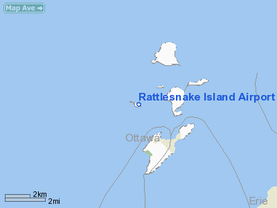
Rattlesnake Island Airport |
Location & QuickFacts
| FAA Information Effective: | 2008-09-25 |
| Airport Identifier: | 58OH |
| Airport Status: | Operational |
| Longitude/Latitude: | 082-50-49.6780W/41-40-45.1750N
-82.847133/41.679215 (Estimated) |
| Elevation: | 586 ft / 178.61 m (Estimated) |
| Land: | 0 acres |
| From nearest city: | 3 nautical miles NW of Put In Bay, OH |
| Location: | Ottawa County, OH |
| Magnetic Variation: | 06W (1985) |
Owner & Manager
| Ownership: | Privately owned |
| Owner: | R.i. Resort Prop. Inc. |
| Address: | 1228 Euclid Ave Rm330
Cleveland, OH 44115 |
| Phone number: | 216-241-6263 |
| Manager: | Peggy Amey |
| Address: | Island Airline
Port Clinton, OH 43453 |
| Phone number: | 419-285-2861 |
Airport Operations and Facilities
| Airport Use: | Private |
| Wind indicator: | Yes |
| Segmented Circle: | No |
| Control Tower: | No |
| Landing fee charge: | No |
| Sectional chart: | Detroit |
| Region: | AGL - Great Lakes |
| Boundary ARTCC: | ZOB - Cleveland |
| Tie-in FSS: | CLE - Cleveland |
| FSS on Airport: | No |
| FSS Toll Free: | 1-800-WX-BRIEF |
Airport Services
| Airframe Repair: | NONE |
| Power Plant Repair: | NONE |
Runway Information
Runway E/W
| Dimension: | 1500 x 150 ft / 457.2 x 45.7 m |
| Surface: | TURF, |
| |
Runway E |
Runway W |
| Traffic Pattern: | Left | Left |
|
Runway N/S
| Dimension: | 988 x 150 ft / 301.1 x 45.7 m |
| Surface: | TURF, |
| |
Runway N |
Runway S |
| Traffic Pattern: | Left | Left |
|
Radio Navigation Aids
| ID |
Type |
Name |
Ch |
Freq |
Var |
Dist |
| PCW | NDB | Port Clinton | | 423.00 | 06W | 9.7 nm |
| PT | NDB | Pelee Island | | 283.00 | 05W | 10.0 nm |
| RYS | NDB | Grosse Ile | | 419.00 | 06W | 28.8 nm |
| G | NDB | Golf | | 398.00 | 05W | 35.1 nm |
| QG | NDB | Windsor | | 353.00 | 06W | 38.1 nm |
| FZI | NDB | Fostoria | | 379.00 | 05W | 38.5 nm |
| TII | NDB | Tiffin | | 269.00 | 05W | 38.5 nm |
| VQ | NDB | Cargl | | 230.00 | 05W | 41.0 nm |
| CL | NDB | Harri | | 344.00 | 07W | 44.7 nm |
| TOL | TACAN | Toledo | 072X | | 05W | 43.1 nm |
| SKY | VOR/DME | Sandusky | 029X | 109.20 | 04W | 17.1 nm |
| YQG | VOR/DME | Windsor | 085X | 113.80 | 06W | 34.3 nm |
| DJB | VOR/DME | Dryer | 083X | 113.60 | 05W | 36.4 nm |
| VWV | VOR/DME | Waterville | 078X | 113.10 | 02W | 38.1 nm |
| DXO | VOR/DME | Detroit | 081X | 113.40 | 06W | 39.6 nm |
| CRL | VORTAC | Carleton | 104X | 115.70 | 03W | 35.2 nm |
| DTW | VOT | Detroit Met Wayne | | 109.80 | | 40.3 nm |
| DET | VOT | Detroit City | | 111.60 | | 44.3 nm |
| YIP | VOT | Willow Run | | 112.00 | | 45.0 nm |
| CLE | VOT | Cleveland | | 110.40 | | 47.7 nm |
Remarks
- CARETAKER HOME ON FIELD BUT NO WIRES.
- EXISTED PRIOR TO 1959.
Images and information placed above are from
http://www.airport-data.com/airport/58OH/
We thank them for the data!
| General Info
|
| Country |
United States
|
| State |
OHIO
|
| FAA ID |
58OH
|
| Latitude |
41-40-45.175N
|
| Longitude |
082-50-49.678W
|
| Elevation |
586 feet
|
| Near City |
PUT IN BAY
|
We don't guarantee the information is fresh and accurate. The data may
be wrong or outdated.
For more up-to-date information please refer to other sources.
|
|


