 |
|
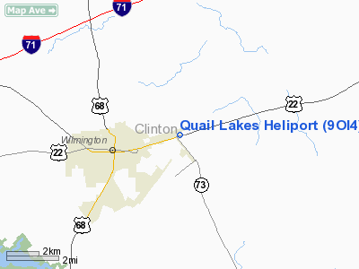
Location & QuickFacts
| FAA Information Effective: | 2008-09-25 |
| Airport Identifier: | 9OI4 |
| Airport Status: | Operational |
| Longitude/Latitude: | 083-46-52.7290W/39-27-17.2210N
-83.781314/39.454784 (Estimated) |
| Elevation: | 1057 ft / 322.17 m (Estimated) |
| Land: | 6 acres |
| From nearest city: | 2 nautical miles E of Wilmington, OH |
| Location: | Clinton County, OH |
| Magnetic Variation: | 04W (1985) |
Owner & Manager
| Ownership: | Privately owned |
| Owner: | Quail Lakes Lodge |
| Address: | 2817 Hwy 22 East
Wilmington, OH 45177 |
| Phone number: | 513-382-5533 |
| Manager: | Raj. M. Patel |
| Address: | 2817 Hwy 22 East
Wilmington, OH 45177 |
| Phone number: | 513-382-5533 |
Airport Operations and Facilities
| Airport Use: | Private |
| Wind indicator: | Yes |
| Segmented Circle: | No |
| Control Tower: | No |
| Lighting Schedule: | DUSK-2400 |
| Landing fee charge: | No |
| Sectional chart: | Cincinnati |
| Region: | AGL - Great Lakes |
| Boundary ARTCC: | ZID - Indianapolis |
| Tie-in FSS: | DAY - Dayton |
| FSS on Airport: | No |
| FSS Toll Free: | 1-800-WX-BRIEF
OR LOCAL CALL 382-0033. |
Airport Communications
Airport Services
Runway Information
Helipad H1
| Dimension: | 25 x 25 ft / 7.6 x 7.6 m
LNDG-TKOF AREA 75 X 75'. |
| Surface: | CONC, |
| |
Runway H1 |
Runway |
| Traffic Pattern: | Left | Left |
| Markings: | Basic, | , |
| Obstruction: | 75 ft twr | |
|
Radio Navigation Aids
| ID |
Type |
Name |
Ch |
Freq |
Var |
Dist |
| IL | NDB | Airbo | | 407.00 | 04W | 3.0 nm |
| HW | NDB | Cubla | | 299.00 | 04W | 7.5 nm |
| XEN | NDB | Xenia | | 395.00 | 03W | 17.1 nm |
| HOC | NDB | Hillsboro | | 278.00 | 05W | 19.7 nm |
| CSS | NDB | Court House | | 414.00 | 05W | 20.1 nm |
| CCJ | NDB | Clark County | | 341.00 | 04W | 25.2 nm |
| MDE | NDB | Madeira | | 379.00 | 04W | 30.1 nm |
| PWF | NDB | Sportys | | 245.00 | 04W | 30.4 nm |
| ISZ | NDB | Cincinnati-blue Ash | | 388.00 | 04W | 30.9 nm |
| HKF | NDB | Hook Field | | 239.00 | 04W | 31.0 nm |
| LUK | NDB | Cincinnati | | 335.00 | 04W | 31.5 nm |
| UYF | NDB | London | | 263.00 | 06W | 32.3 nm |
| BU | NDB | Boutn | | 230.00 | 05W | 34.5 nm |
| RZT | NDB | Ross County | | 236.00 | 05W | 34.9 nm |
| HAO | NDB | Hamilton | | 260.00 | 04W | 37.1 nm |
| AMT | NDB | West Union | | 359.00 | 04W | 37.4 nm |
| CYO | NDB | Circleville | | 366.00 | 05W | 37.4 nm |
| PZO | NDB | Peebles | | 329.00 | 02W | 38.4 nm |
| EOP | NDB | Waverly | | 385.00 | 06W | 43.1 nm |
| OS | NDB | Fuler | | 515.00 | 05W | 45.9 nm |
| OXD | NDB | Oxford | | 282.00 | 04W | 46.5 nm |
| CHC | NDB | Grens | | 272.00 | 04W | 48.2 nm |
| DKG | NDB | Don Scott | | 348.00 | 05W | 49.7 nm |
| XSF | TACAN | Springfield | 065X | | 04W | 23.2 nm |
| FFO | TACAN | Patterson | 099X | | 04W | 25.3 nm |
| LCK | TACAN | Rickenbacker | 069X | | 05W | 44.8 nm |
| XUB | VOR | Yellow Bud | | 112.50 | 05W | 37.5 nm |
| MXQ | VOR/DME | Midwest | 076X | 112.90 | 04W | 1.8 nm |
| SGH | VOR/DME | Springfield | 079X | 113.20 | 04W | 23.1 nm |
| DQN | VOR/DME | Dayton | 092X | 114.50 | 01W | 44.1 nm |
| DAY | VOT | Dayton J M Cox-day | | 111.00 | | 33.7 nm |
| LUK | VOT | Cincinnati Muni/lunken | | 108.40 | | 35.2 nm |
Remarks
- SAFE OPNS CANNOT BE ASSURED DUE TO INTERACTION WITH ACFT ON FINAL APCH TO AIRBORNE ARPK.
Images and information placed above are from
http://www.airport-data.com/airport/9OI4/
We thank them for the data!
| General Info
|
| Country |
United States
|
| State |
OHIO
|
| FAA ID |
9OI4
|
| Latitude |
39-27-17.221N
|
| Longitude |
083-46-52.729W
|
| Elevation |
1057 feet
|
| Near City |
WILMINGTON
|
We don't guarantee the information is fresh and accurate. The data may
be wrong or outdated.
For more up-to-date information please refer to other sources.
|
|


